Forecasts Point to an Increasing Chance for Rain the First Half of Next Week
May 21, 2025
A quick update on the forecasted weather for Memorial Day and next week. For the past couple of days, computer-forecast solutions have been consistently showing a change in the weather pattern will take place across Texas next week and this new pattern could bring widespread and potentially significant totals of rain to our region.
Weather conditions Thursday through Saturday are forecast to remain generally dry and summer-like, although there will be a slight chance (30 percent chance) for a few scattered thunderstorms across parts of the Hill Country and the Interstate 35 corridor Thursday evening into Thursday night. Most rain amounts, if any, should stay below a quarter inch.
Sunday’s weather is predicted to be mostly sunny and continued hot. However, forecasters will be monitoring developments across West Texas Sunday afternoon where an approaching wave of low pressure is expected to cause the development of scattered thunderstorms along the dry line. The area of storms is forecast to spread east through the Hill Country and Central Texas Sunday night. The probability for rain and storms Sunday night is predicted to be near 50-60 percent. Isolated strong to severe storms will be possible.
Memorial Day weather is shaping up to be mostly cloudy and less hot. There will be a 50 to 60 percent chance for scattered showers and thunderstorms across the entire region throughout the day, continuing into Monday night. A cold front is forecast to slide south across the area while a couple of waves of low pressure track northeast out of Mexico. This setup will be favorable for the development of widespread showers and thunderstorms.
Rain amounts Sunday evening through Monday evening are forecast to average close to an inch across the Hill Country and Central Texas regions, and around a half inch towards the coast.
Periods of showers and thunderstorms are forecast to continue next Tuesday through Wednesday, followed by lower chances for rain next Thursday and Friday.
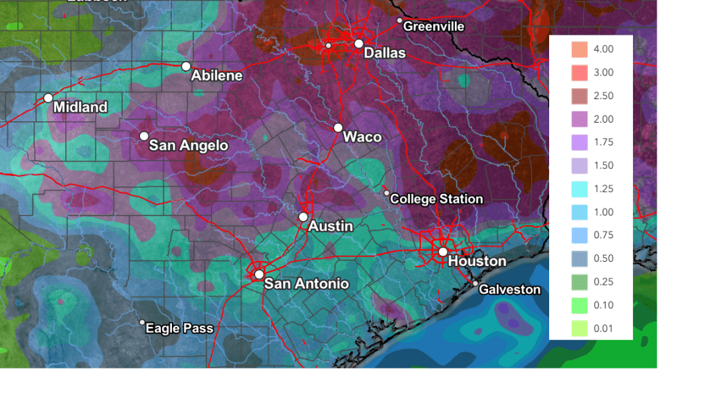
The National Weather Service’s rainfall forecast through next Wednesday evening calls for totals of 1-2 inches across the Hill Country, with totals of 1-1.5 inches across the rest of the region. Depending on how this situation evolves, higher totals will certainly be possible.
NWS Rainfall Forecast Valid through 7 pm Next Wednesday:
Interestingly, there are signs this unsettled weather pattern may also extend into the first full week of June.
Temperatures next week will be less hot. Daily high temperatures are forecast to generally be in the upper 80s, with lows in the 60s.
Bob
Social Media