Forecast for Central Texas

 0%0%0%
 0%0%
0%0%
Reports from LCRA’s Hydromet
Rainfall summaryTemperature summary
Humidity summary
Bob's Blog on Central Texas Weather
Quiet Weather Expected this Week. Trending Warmer and More Humid
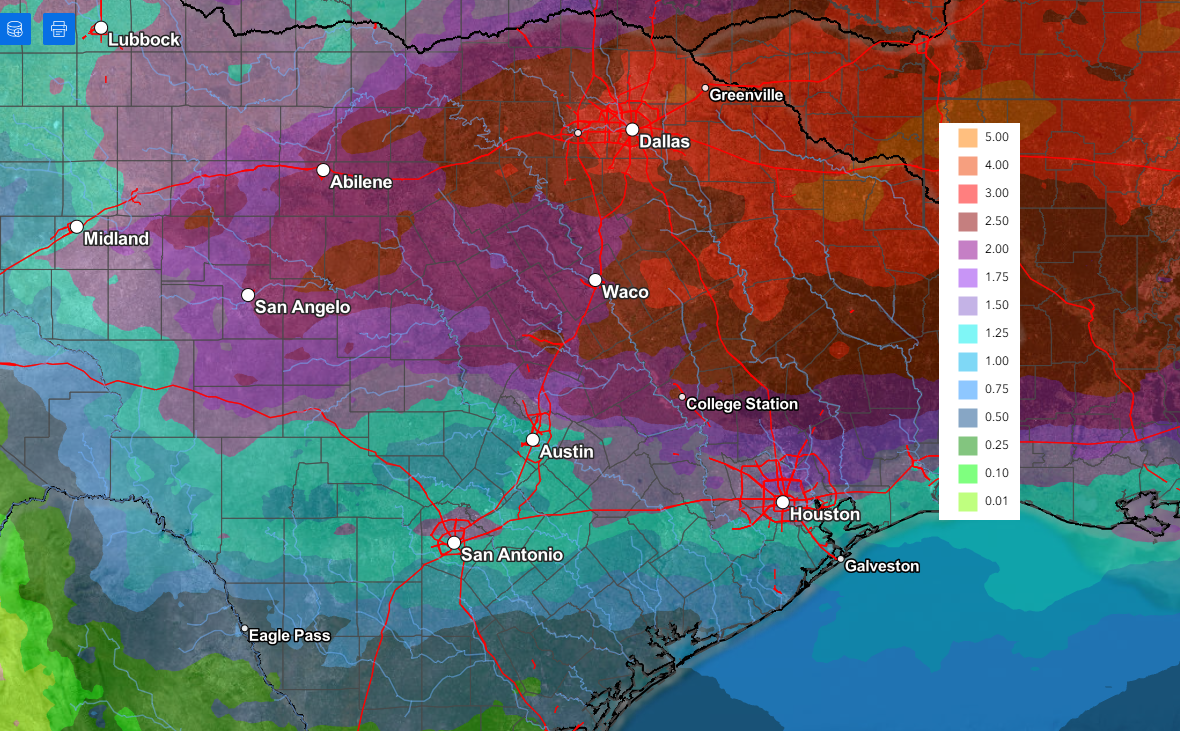
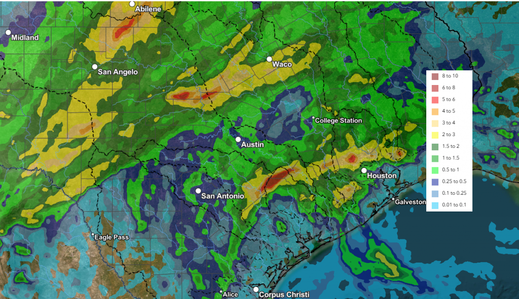
Sunday evening’s stormy weather has pushed well to the east of our region thanks to the passage of a weak cold front. Sunday’s storms produced wind gusts of 40-50 mph across much of the area. Austin-Bergstrom International Airport and Georgetown Municipal Airport both reported wind gusts to 64 mph. Hail was reported with some of the storms, with sizes ranging from pea size to near 1 inch in diameter.
Rainfall was hit and miss, with some locations reporting totals up to 3-4 inches, with several spots recorded less than a quarter inch. Some of the most widespread heavy rain appears to have occurred over the area between Austin and College Station. LCRA’s highest gauged total was 3 inches at a location in western San Saba County. A CoCoRaHS rainfall observer located just east of Bastrop recorded a storm total of 4.13 inches.
NWS Estimate of Rain Falling Between 7 am Sunday and 7 am Monday:
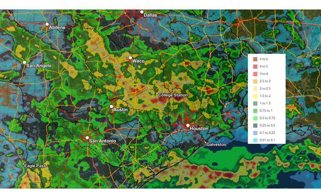
Data courtesy of NWS West Gulf River Forecast Center
The weather this week is expected to be sunny and quiet. A large ridge of high pressure situated over northern Mexico and the western U.S. is forecast to slowly shift east through the week, keeping the weather across Texas dry and warm. Light northerly winds behind this morning’s cold front are expected to keep the temperature a little lower today through Tuesday.
- High temperatures Monday will range from the mid-70s to the low 80s
- Lows Tuesday morning will include the upper 50s across the Hill Country, the low 60s across Central Texas, and the mid-60s near the coast
- High temperatures Tuesday will be in the low and mid-80s
- Lows Wednesday morning will be in the low and mid-60s
Warmer readings and higher relative humidity levels look to return beginning Wednesday and continue through the weekend as southerly breezes increase off the Gulf. Expect southerly breezes to be in the range of 10-15 mph through the period. Daily high temperatures are forecast to be near 88-90 degrees. Low temperatures are predicted to generally be in the low and mid-70s.
A chance for scattered rain showers and thunderstorms will enter the forecast on Sunday as a trough of low pressure begins to set up across the Desert Southwest this weekend. Disturbances rotating around the trough are forecast to begin moving over Texas Sunday and continue through the middle of next week. Extended-range forecast guidance suggests totals of 0.25 to 0.5 inches Sunday, with the possibility for some higher totals early next week. Stay tuned for additional updates.
No significant change in the temperature is forecast through next week.
Solar Activity Alert
The odds of an Earth-directed solar flare are increasing this week as sunspot 4436 turns toward our planet. On May 10th, the active sunspot region produced an M5.7-class solar flare, which blew a massive hole in the sun’s atmosphere. This flare appears to be heading for a near miss with Earth and should pass by on Wednesday.
The next explosion might not miss. This sunspot has had a history of producing large flares. Last week while it was on the far side of the sun it produced at least 5 Coronal Mass Ejections (CMEs). If the serial explosions continue in the days ahead, Earth will be inside the strike zone. (Spaceweather.com)
Have a great week!
Bob
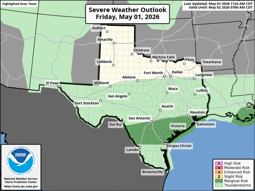
Severe Storms Possible Sunday Night
A quick heads up on the possible development of severe thunderstorms Sunday evening and Sunday night.
Mother’s Day weather is shaping up to be mostly sunny and quite warm with a high temperature near 90-92 degrees.
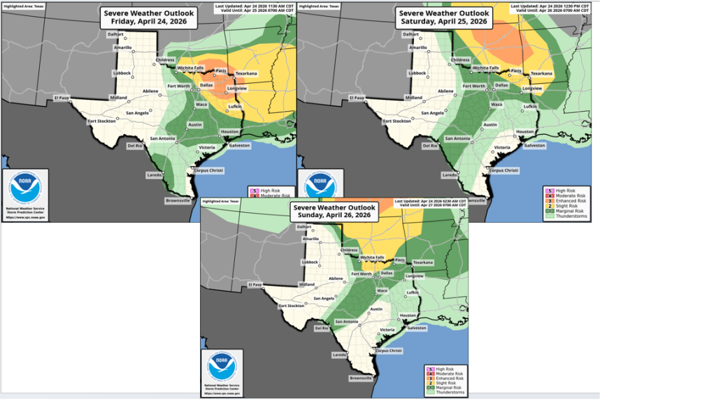
Attention turns to West and Northwest Texas late Sunday afternoon where scattered to numerous thunderstorms are forecast to develop along a southward moving cold front. At the same time, a vigorous trough of low pressure pushing east from the southern Rockies is expected to add significant atmospheric lift to cause these thunderstorms to become strong to severe. Across West Texas, a large cluster of thunderstorms is forecast to develop along the cold front late Sunday afternoon. These thunderstorms are forecast to move southeast with the cold front Sunday evening and Sunday night.
The area of strong and severe storms is predicted to spread southeast across the Hill Country and Edwards Plateau regions between 7 pm and 11 pm. The storms look to move across the Austin/Interstate 35 corridor between 11 pm and 1 am, eastern Central Texas and coastal counties between 1 am and 5 am. The storm activity is expected to be weakening when it approaches the coastal plains region late Sunday night.
High-resolution forecasts indicate atmospheric conditions Sunday evening will be favorable for many of the storms along the cold front to become severe. The primary severe weather hazards are expected to be damaging winds that could exceed 75 mph and large hail up to 2 inches in diameter.
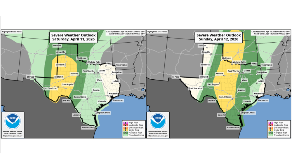
The Storm Prediction Center has placed much of West Texas and the Hill Country, including Williamson County and the western half of Travis Country, under an Enhanced Risk (a 3 out of 5 risk) for severe thunderstorms through Sunday night. The area between Austin and Columbus has been placed under a 2 out of 5 risk, while areas southeast Columbus have been placed under a 1 out of 5 risk.
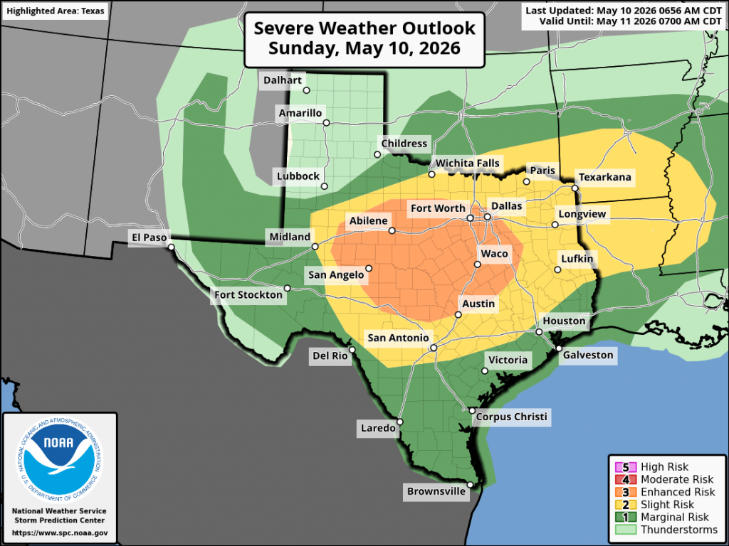
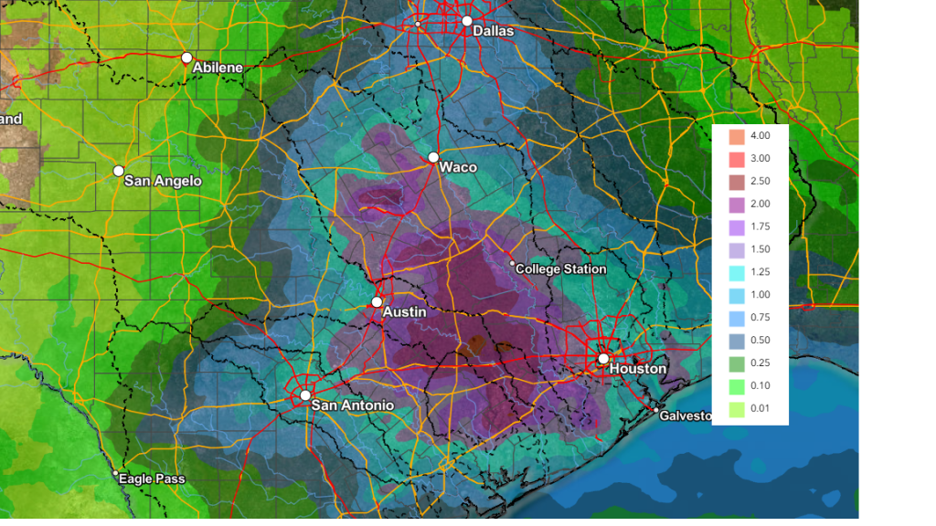
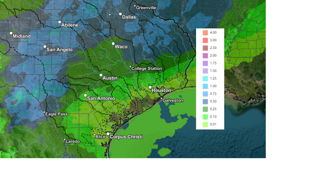
Rainfall from line of thunderstorms is forecast to generally average between 0.5 and 1 inch. However, some pockets of 2-4 inch totals will be possible—especially if the front happens to move slower than currently forecast.
NWS Rainfall Forecast Valid through 7 am Monday:
Sunny and dry weather is forecast Monday through Friday. High temperatures will be in the low 80s Monday and Tuesday but look to warm close to 90 degrees Thursday and Friday.
Bob
A Chance for Showers trough the Weekend. Dry and Warmer Weather Next Week
We’re looking at a fairly complicated weekend forecast as several weather features come together, possibly producing areas of rain and storms. While rain is forecast, the entire weekend is not expected to be a rainout. Sunday morning into Sunday afternoon (Mother’s Day) should be generally dry and sunny, before more rain and storms move in late in the day.
Friday’s weather maps showed an area of low pressure in the upper atmosphere located over northern Mexico, to the west of the Texas Big Bend. The low is forecast to track east, moving across Central and Southeast Texas Saturday afternoon. Weak atmospheric lift from the approaching trough is forecast to spread over the region Friday afternoon through about midday Saturday. With lift from this system being weak, widespread, or heavy rain is not anticipated. In addition, the threat for any severe storms will be quite low.
With the passing low pressure system, there will be a 20-30 percent chance for scattered rain showers and isolated thunderstorms across the region Friday afternoon through Friday night. The chance for rain and storms will increase to around 40 percent Saturday morning through early Saturday afternoon as the low moves overhead. The chance for rain will end from west to east Saturday afternoon as the trough exits the region. Clouds should decrease with the sky becoming mostly sunny Saturday afternoon. Expect warmer temperatures, with readings climbing to the mid-80s. Clear and quiet weather is predicted for Saturday night.
Rain Amounts
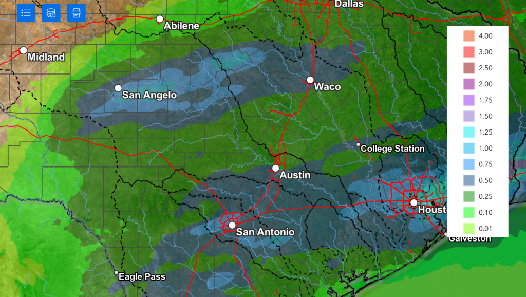
Totals through Saturday afternoon are forecast to generally average less than a quarter inch. A couple of isolated heavier totals will be possible across the coastal plains.
NWS Rainfall Forecast Valid through 7 pm Saturday:
Sunday and Sunday Night
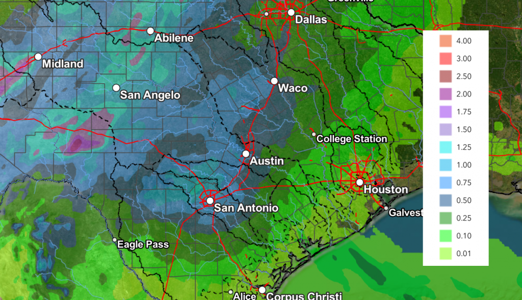
There will be another chance for rain showers and thunderstorms Sunday afternoon into Sunday evening when a trough of low pressure drives a Canadian cold front south through the area. The front is predicted to reach the northern Hill Country about mid-afternoon, the Austin area in the late afternoon and early evening, and the coastal zone late Sunday evening. Forecasts are showing a favorable setup for an area of rain and thunderstorms to develop just ahead of and along the cold front as it makes its way south. In fact, some of these storms could be strong to severe. Storm Prediction Center Forecasters have placed all of Central Texas and the Hill Country under a Marginal Risk for severe thunderstorms through Sunday night. Large hail and damaging winds will be in the primary severe weather threats. The chance for rain should end shortly behind the cold front late Sunday evening. Rain amounts Sunday afternoon through Sunday evening are forecast to generally average between 0.25 and 0.5 inches, with isolated totals to near 1 inch possible. High temperatures Sunday are forecast to be in the mid and upper 80s.
Next Week
Sunny, dry, and quiet weather is forecast across the region next Monday through Friday as our region comes under the influence of a developing ridge of high pressure over northern Mexico and the southwestern U.S. This feature is predicted to bring an early season triple-digit heatwave to much of the Southwest and the southern Rockies early next week. Fortunately, the extreme heat is expected to remain to our west. High temperatures Monday and Tuesday are predicted to be in the mid-80s, warming to around 88-90 degrees Wednesday through Friday.
Longer-range forecasts do point to a chance for rain developing across our region next weekend as the ridge shifts up to the Midwest and a trough of low pressure pushes into the Desert Southwest.
No significant change in the temperature is forecast over the next ten days.
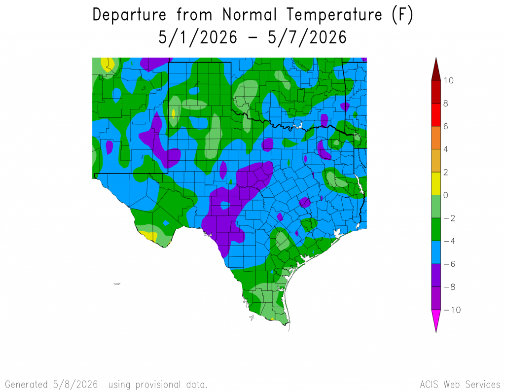
A Somewhat “Cooler” Start to May
The temperature for the first seven days of May has averaged between 4 and 6 degrees below normal across the region. A couple of cold fronts and periods of clouds have helped to keep the temperature down. Will these cooler temperatures last through all of May? It’s not likely, but unusually warm weather doesn’t appear to be on the horizon anytime soon.
Have a great weekend!
Bob
Dry and Cooler this Weekend. Monitoring Another Chance for Rain Late Week
Wet and unsettled weather is in place across the region on this Friday as an overrunning pattern continues. Since early Thursday, waves of rain showers and scattered thunderstorms have spread from southwest to northeast across much of the state due to an approaching trough of low pressure. Totals through 7 am Friday have been highest along and just north of the Interstate 10 corridor, where widespread 3-4 inches amounts were recorded. Across the rest of the region, totals have generally averaged between 0.5 and 2 inches. As of 7 am, locations near the coast had only received a few hundredths of an inch.
NWS Estimate of Rain Falling Between 7 am Thursday and 7 am Friday:
Courtesy West Gulf River Forecast Center
Additional waves of rain showers and thunderstorms can be expected Friday afternoon into Friday evening as a large trough of low pressure slowly pulls north from northern Mexico through the Texas Panhandle. Small waves of low pressure rotating around the main trough will continue pull Gulf moisture up and over a stalled cold front located along the Texas coast, resulting in additional rounds of moderate to heavy rain showers and scattered thunderstorms. Some of the rain may at times be locally heavy. The National Weather Service has posted a Flood Watch for the Hill Country, Central Texas and coastal region through Friday evening.
Do note that some of the storms across the coastal plains region will have a low chance for becoming strong to severe. The Storm Prediction Center has placed this region under a Marginal Risk for severe storms through Friday evening. The primary severe weather threats will be large hail and damaging winds, although a weak tornado cannot be ruled out. Elsewhere, the threat for severe storms through Friday evening will be low.
Forecasts call for the rain to taper off from west to east Friday evening as the upper trough tracks northeast of our region. All of the rain should be east of our region by about midnight. Additional rain amounts through Friday evening are predicted to average between 1 and 1.25 inches across the Hill Country, between 1 and 2 inches across Central Texas, and between 1 and 3 inches across the coastal region. The coastal area could see some isolated totals to near 5 inches.
Breezy and cooler conditions can be expected late Friday afternoon into Friday evening as a second cold front presses south through the area. Expect northeasterly winds with speeds of 10-20 mph and occasional gusts to near 35 mph Friday evening and Friday night. Clouds should clear Friday night. This will be followed by a mostly sunny sky Saturday and Sunday.
- Lows Saturday morning will generally be in the low and mid-50s
- High temperatures Saturday are forecast to be in the low 70s
- Lows Sunday morning will generally be near 48-50 degrees
- High temperatures Sunday will generally be in the mid-70s
- Lows Monday morning are forecast to be in the upper 50s
For next week, forecasts call for mostly sunny to partly cloudy and dry weather Monday and Tuesday. Warmer readings can be expected. Highs Monday are predicted to be in the low 80s. Highs Tuesday are predicted to be near 88-90 degrees.
The forecast for Wednesday calls for just a slight chance for showers and thunderstorms across the region when a weak cold front presses south and stalls across North Texas. A somewhat better chance for rain is forecast Thursday when a stronger cold front tracks south across the region. A chance for rain showers and thunderstorms looks to continue Friday into next weekend as another trough of low pressure approaches from the southwest. High temperatures late week into next weekend are predicted to fall to the upper 70s to low 80s.
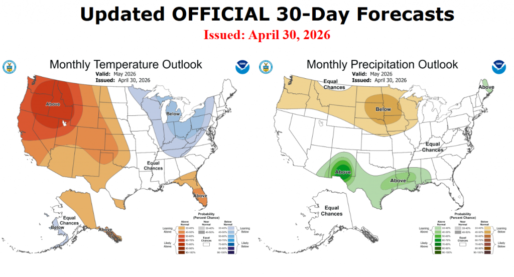
Above Normal Rainfall Predicted for May
On Thursday, NOAA’s Climate Prediction Center issued an updated outlook for the month of May. For Texas, the outlook leans toward above normal rainfall, with no clear trend for temperature. The wet pattern we saw in April is expected to continue into May. Additional cold fronts are forecast at least through the first half of the month.
Have a great weekend!
Bob
Increasing Chances for Rain and Storms Thursday and Friday. Turning Cooler Late Week
Unseasonably warm and muggy conditions will be in place through the middle of the week before widespread, soaking rains and cooler air move in late week behind a pair of cold fronts.
Monday afternoon through Tuesday night, little change in the weather is predicted across our region. While the atmosphere will be quite moist and unstable, a large area of warm air, or cap in the middle atmosphere, is expected to keep a lid on any thunderstorms which might want to develop. The West Texas dry line is forecast to push east into the Hill Country on both days, but the cap should limit thunderstorm development. There’s a very low-end chance a couple of isolated thunderstorms could form over the Edwards Plateau late Monday evening and again Tuesday evening, but the chance for rain here will be less than 20 percent.
Expect widespread nighttime and morning clouds, followed by a partly cloudy sky both afternoons. High temperatures both days will be near 90-92 degrees. Light southerly breezes Monday afternoon and Monday night will increase to 10-15 mph on Tuesday.
Changes in the weather are predicted to take place beginning Wednesday when a weak cold front pushes south out of Northwest Texas. The front is forecast to spread southeast across the Hill Country Wednesday morning and through Central Texas Wednesday afternoon, pulling up stationary near Interstate 10 Wednesday evening. There will be a slight chance for a few showers and thunderstorms along and behind the front across the Hill Country and Central Texas regions Wednesday into Wednesday night. The probability for rain will be near 30 percent. There will be a low risk some of these storms may be strong to severe. The Storm Prediction Center has placed most of the region under a 1 out of 5 risk for severe storms Wednesday and Wednesday night. The greatest threats will be large hail and damaging winds.
Wednesday’s temperature will trend a little cooler for areas behind the cold front. Expect highs here to be near 80 degrees. Meanwhile, highs across the coastal region are predicted to remain in the low 90s.
The chance for rain showers and thunderstorms will increase across the area Thursday through Friday as a trough of low pressure begins to track northeast out of the Desert Southwest. Atmospheric lift out ahead of the approaching trough is expected to pull considerable Gulf moisture north over the stalled cold front. Showers and scattered thunderstorms are expected to increase in coverage and intensity throughout the day Thursday, with multiple rounds of rain continuing Thursday night through Friday night. The probability for rain will be near 70 percent. As of now, the chance for severe storms Thursday and Friday appears low. Light showers and a few thunderstorms look to continue Friday night into Saturday morning. All the rain is forecast to end by midday Saturday as the upper trough exits to the northeast.
Forecasts are pointing toward the possibility for some significant totals of rain—especially across the Hill Country week.
National Weather Service rainfall forecasts through Saturday evening call for general totals of 1-3 inches across the Hill Country, and between 1 and 2 inches for most other locations.
NWS Rainfall Forecast Valid through 7 pm Saturday:
Much cooler air is forecast to spread across the area behind a second cold front Friday and Friday night! The cool air is expected to remain across the area through the weekend.
- High temperatures Friday are forecast to be in the mid and upper 60s across the Hill Country and Central Texas regions, and in the mid-70s towards the coast
- High temperatures Saturday will be in the upper 60s to low 70s
- High temperatures Sunday are predicted to be in the low and mid-70s
- Lows Saturday morning will range from the upper 40s across the Hill Country, the upper 50s near the coast
- Lows Sunday morning will include the mid-40s across the Hill Country, the upper 40s across Central Texas, and the lower 50s across the coastal region
- Lows Monday morning are forecast to be in the low and mid-50s
Clouds should clear Saturday afternoon, followed by sunny weather on Sunday.
Looking ahead to next week, sunny and dry weather is forecast Monday through Wednesday. However, a chance for rain showers and thunderstorms will return to the forecast for Thursday and Friday as another trough of low pressure approaches from the west.
High temperatures next week are predicted to generally be in the mid and upper 80s.
Have a great week!
Bob
Summer-Like Weather With Just a Few Isolated Thunderstorms into Early Next Week
Warm and humid weather has returned to our region following the cool and wet spell earlier this week. In fact, the weather this weekend into next week going to feel a bit like early summer as afternoon temperatures climb to around 90-92 degrees.
For Friday through Monday, generally quiet, dry, and warm weather is forecast. However, a few isolated, mainly afternoon and evening thunderstorms will be possible across the region as the atmosphere remains quite moist and potentially unstable. Friday’s weather maps showed the southern branch of the jet stream flowing from southern California to the southern Plains, then north to the Great Lakes. The jet stream is forecast to stay in roughly this same configuration through the weekend, keeping the greatest threat for thunderstorms well to our north across Oklahoma and the Red River Valley. Across the Hill Country, Central Texas, and coastal regions, a couple of isolated thunderstorms will be possible each afternoon and evening as weak disturbances pass over the region from the west. Lift from the these passing disturbances will likely be offset by a strong stable layer, or cap, in the middle atmosphere covering the region. However, should this stable layer happen to weaken, atmospheric conditions are primed for rapid strong to severe thunderstorm development. The probability for this occurring at any given location will at best only be 20 percent.
Another feature which could spark the development of a few isolated thunderstorms, mainly across the Hill Country, will be the West Texas dry line. Forecasts call for the dry line to push east to Edwards Plateau and Concho Valley regions each afternoon. The boundary could potentially weaken the stable layer enough to cause the development of a few scattered thunderstorms that will then spread to the east. These thunderstorms could also quickly become strong to severe. The probability for storms will at best be near 20 percent.
The Storm Prediction Center has placed most of the region under a Marginal Risk (a 1 out of 5 risk) for severe thunderstorm development Friday. For Saturday and Sunday, only the Hill Country continues under the Marginal Risk. Should thunderstorms develop, the primary severe weather risks will be large hail and damaging downburst winds.
Aside from this slight chance for thunderstorms, the weekend weather will feature widespread nighttime and morning clouds, followed by a partly cloudy sky in the afternoon.
- High temperatures Friday through Sunday are predicted to be near 90-92 degrees across the Hill Country and Central Texas regions, and near 88-90 degrees across the coastal region
- Lows will be in the upper 60s to low 70s
Looking ahead to next week, no significant change in the weather is expected Monday through Wednesday. A couple of isolated thunderstorms will be possible—mainly across the Hill Country in the vicinity of the dry line. The warm temperatures look to continue, with highs near 90-92 degrees.
There will be an increased chance for rain showers and thunderstorms Thursday afternoon into Thursday evening when a strong cold front pushes south through the area. An area of rain and storms is predicted to develop along and just behind the boundary. Rain amounts with the front are forecast to be somewhere in the range of 0.25 to 0.5 inches.
The front is expected to bring a blast of noticeably cooler air that will last through next weekend. Expect high temperatures next Friday through Sunday to be in the 70s, with lows in the 50s and 60s. Dry weather is predicted Friday through next weekend.
Have a great weekend!
Bob
Rain and Thunderstorms Expected through Wednesday. Conditions Trending Drier Late Week
Rain showers and scattered thunderstorms developed across the Edwards Plateau and parts of West Texas Sunday night as a small wave of low pressure pushed east out of northern Mexico. The rain expanded east to cover the Hill Country and Central Texas regions Monday morning into Monday afternoon. According to LCRA’s Hydromet and Doppler radar estimates as of midday Monday, the highest totals so far have occurred over the area from southwest of San Angelo, southeast to Junction and Kerrville. Here totals of 1-2 inches have been recorded. Totals of 4-5 inches have been estimated to have occurred over southeastern Schleicher County, to the southeast of Eldorado. For most other locations, totals have generally been less than a half inch.
Periods of rain showers and scattered thunderstorms are forecast across the entire region Monday afternoon and Monday night as the approaching trough of low pressure creates a favorable setup for light to moderate overrunning rain. The threat for any strong to severe storms will be low. Lows Tuesday morning will range from the mid-50s across the Hill Country to the low 60s near the coast.
Additional showers and thunderstorms are forecast to develop across the northern Mexico and the Rio Grande Plains Monday evening in response to a second trough of low pressure pushing to the east out of northern Mexico. High resolution forecasts call for this activity to spread to the east-northeast through the Hill Country, Central Texas, and coastal regions late Monday night into Tuesday morning. There appears to be some potential for some of the rain to train over the same areas during this period, which could lead to higher totals. Overall, this rain is predicted to be a bit heavier in intensity, compared to Monday’s rain. With the ground wet from recent rain, some localized flooding will be possible.
Tuesday afternoon into Tuesday night, the most favorable area for rain and thunderstorms will be east of Interstate 35 as the upper trough lifts northeast to Oklahoma. There will be a 20-30 percent chance for additional showers and thunderstorms across the Hill Country, and a 30-40 percent chance for showers for areas along and east of I-35. Totals Monday night through Tuesday night are forecast to generally average between 1 and 3 inches, with a couple of isolated totals to near 4 inches possible. High temperatures Tuesday are predicted to be in the upper 60s.
Additional scattered showers and thunderstorms look to continue across the region Wednesday as a moist and unstable atmosphere persists over the region. The highest probability for rain (40-50 percent) will be for areas east of I-35, while the chance for rain across the Hill Country will only be near 20-30 percent. Rain amounts Wednesday look to range from 0.25 to 0.5 inches across the coastal plains, to less than a quarter inch across the Hill Country. The temperature will be warmer, with highs around 80-82 degrees.
WPC’s 2-day Rainfall Forecast Valid through 7 pm Wednesday:
Dry weather is forecast Thursday and Friday as a weak ridge of high pressure sets up over Texas. Expect a partly to mostly cloudy sky both days. High temperatures are predicted to be in the mid and upper 80s.
For the upcoming weekend, forecasters will be monitoring West Texas where a few thunderstorms may develop along the dry line each afternoon. A couple of these storms could track as far east as the Hill Country region in the evening and early nighttime periods. There will be a potential for some of these storms to become severe. Otherwise, weather conditions are shaping up to be partly cloudy and warm. High temperatures will continue in the mid and upper 80s.
Looking ahead to next week, forecasts are calling for generally dry weather Monday and Tuesday. There will be a slight chance for afternoon showers and thunderstorms next Wednesday through Friday. Rain amounts next week are not expected to be very high. There are indications for a somewhat better chance for rain developing next weekend.
Have a great week!
Bob
Showers and Thunderstorms Saturday. Temperatures Trend Cooler Saturday through Monday
Another period of wet and unsettled weather will be developing this weekend, with the wet pattern expected to last into early next week.
Friday’s weather is predicted to remain quiet ahead of weekend weather changes. Expect a partly cloudy sky with high temperatures in the mid and upper 80s. A strengthening pressure gradient across the state will cause breezy southerly winds, with speeds of 10-15 mph and occasional gusts to 30 mph Friday afternoon through Friday night.
Big changes in the weather are expected to take place Saturday when a strong cold front pushes south across the area. Forecasts call for the cold front to spread across the northern Hill Country just before sunrise, reaching the Austin area about mid-morning. The front should continue moving southeast Saturday afternoon and push off the middle Texas coast in the late afternoon. The front will bring noticeably cooler air and gusty northerly winds. Expect northerly winds at 10-15 mph with occasional gusts to 30 mph Saturday afternoon, continuing through Sunday.
For areas out ahead of the front, there will be a slight chance for a few showers and thunderstorms Saturday morning. An area of showers and isolated thunderstorms is forecast to develop right along the cold front as it presses to the southeast. However, a better chance for showers and scattered thunderstorms is predicted behind the cold front Saturday afternoon through Saturday night as a brief overrunning pattern sets up. With Saturday’s particular setup, the threat for any severe storms looks to be quite low. Periods of rain and occasional thunderstorms can be expected. The probability for rain will be near 50-60 percent. The chance for rain is expected to diminish late Saturday night as the overrunning pattern weakens.
Rain amounts through Sunday morning are forecast to generally average between 0.25 and 0.75 inches, with some isolated totals to near 1 inch possible. Slightly higher totals are forecast for the coastal plains region.
NWS Rainfall Forecast Valid through 7 pm Sunday:
Partly cloudy and generally dry weather is predicted for most areas on Sunday. However, clouds and a few light showers are forecast for the western Hill Country and the Edwards Plateau regions.
Saturday’s cold front is expected to bring noticeably cooler air that should continue into next Tuesday.
- Saturday’s temperature is forecast to climb into the 70s ahead of the front, then fall through the 60s Saturday afternoon
- Lows Sunday morning will range from the upper 40s across the Hill Country, the mid-50s near the coast
- High temperatures Sunday are forecast to be in the low and mid-70s
- Lows Monday morning will be in the low and mid-50s, with upper 50s expected near the coast
- High temperatures Monday are forecast to be in the low and mid-60s
A chance for showers and scattered thunderstorms will return to the forecast beginning Monday morning and continue through Tuesday afternoon as several small waves of low pressure track across Texas out of northern Mexico. Periods of light to moderate rain can be expected, with the probability for rain around 40-50 percent. The threat for severe storms appears to be quite low.
Rain amounts Monday through Tuesday are forecast to generally average between 0.25 and 0.5 inches.
Wednesday through Friday, forecasts call for generally dry and warm weather across the region, although a few isolated showers cannot be ruled out. A better chance for rain looks to develop next weekend. The temperature will trend warmer beginning Wednesday, with high temperatures returning to the low and mid-80s.
Have a great weekend!
Bob
A Chance for Rain and Storms Will Continue into the Upcoming Weekend
An unsettled weather pattern brought periods of rain and thunderstorms to the region over the weekend. An area of storms spread across the northern Hill Country Friday night, producing a large swath of 1–2-inch totals over the area between Rock Springs, Junction, Mason, Llano, and Burnet. The storms on Sunday produced two areas of heavy rain. The first area was southeast of Austin, close to Interstate 10. A widespread area of 2–3-inch totals stretched from just east of Gonzales, to Columbus, to just north of Houston. A core of 7–8-inch totals occurred across northern Lavaca and southern Fayette Counties. The second area of heavy rain occurred across southern San Saba, northern Llano, and northwestern Burnet Counties. Totals within this second area generally ranged between 3 and 6.5 inches. 3-day totals across the rest of the region generally remained below 0.75 inches.
NWS Estimate of Rain Falling Between 7 am Friday and 7 am Monday:
Data courtesy NOAA’s West Gulf River Forecast Center
Monday’s analysis showed the trough of low pressure responsible for this weekend’s wet and unsettled weather has exited northeast of our region. As a result, atmospheric moisture levels have begun to drop from the unusually high levels observed earlier. This means the threat for additional heavy rain has diminished—at least for the time being. Without a source for strong atmospheric lift, only an isolated shower or two is forecast across the region through Monday night. The probability for rain will be less than 20 percent. Expect a partly to mostly cloudy sky Monday afternoon with the temperature warming to the mid-80s.
Tuesday is expected to be another generally dry day across the region. Morning clouds should give way to a partly cloudy sky in the afternoon. Expect high temperatures in the low and mid-80s. Forecasters will be monitoring western Texas where scattered thunderstorms are forecast to develop in the late afternoon along the dry line. High-resolution forecasts call some of the thunderstorms to track east through the western and northern Hill Country Tuesday evening. It’s possible a couple of the storms could reach as far east as Mason and San Saba Counties, before dissipating late Tuesday night. Some of these storms could be strong to severe—producing large hail and damaging winds. Spotty totals of 0.5 to 1 inch are forecast. No rain is predicted for the eastern Hill Country, the Austin/Central Texas area, or the middle Texas coast.
Wednesday and Wednesday night will see a chance for showers and thunderstorms develop across the Hill Country and Central Texas regions as vigorous trough of low pressure moves from the southern Rockies to the Plains states. Moisture levels are expected to rise across the region in advance of the trough, and this may lead to the development of a few showers and isolated thunderstorms Wednesday afternoon. However, a better chance for showers and thunderstorms is forecast to occur late Wednesday afternoon into Wednesday night as an area of rain and thunderstorms develops along the West Texas dry line and spreads to the east. Forecasts call for a broken line of thunderstorms to push east across the Hill Country late Wednesday afternoon into Wednesday evening, then spread east through Central Texas late Wednesday evening. There’s a slight chance a few storms could reach the middle Texas coast after midnight Wednesday night. The probability for rain will be near 40-50 percent. High temperatures Wednesday are predicted to be in the mid-80s.
Some of the storms across the Hill Country could be strong to possibly severe. The Storm Prediction has placed the Hill Country region under a 1 out 5 risk for severe thunderstorms Wednesday and Wednesday night. The primary severe weather threats will be large hail and damaging winds.
Rain amounts Wednesday through Thursday morning across the Hill Country and Central Texas regions are forecast to generally average between 0.25 and 0.5 inches, with isolated totals to around 1 inch possible.
Thursday and Friday are shaping up to be partly cloudy and dry as the upper trough moves off to the northeast, and a more stable atmosphere sets up across the region. High temperatures both days are forecast to be in the mid and upper 80s.
A chance for rain and scattered thunderstorms will return to the forecast late Friday night into Saturday when a moderate cold front sinks south through the region. Forecasts call for the front to spread across the Hill Country Saturday morning, reaching Central Texas early to mid-afternoon, and the coastal region in the late afternoon and early evening. Showers and scattered thunderstorms are forecast ahead of and along the cold front, but another chance for showers and isolated thunderstorms is predicted to develop behind the front Saturday night into Sunday as a weak overrunning pattern takes shape. The probability for rain will be 40-50 percent on Saturday, and near 30-40 percent Saturday night through Sunday.
Temperatures will trend a bit cooler behind the cold front late Saturday through next Monday.
- High temperatures Sunday and Monday are forecast to be in the mid-70s
- Lows Sunday and Monday mornings will range from around 50 degrees across the Hill Country, to the upper 50s near the coast
NOAA’s Weather Prediction Center 7-day total rainfall forecast through next Monday calls for general totals of 0.5 to 1 inch across the Hill Country and less than a half inch for most other locations:
The outlook for next week calls for a slight chance for rain Monday and Tuesday, with a slightly better chance for rain the second half of next week. Forecasts show our region will remain under a southwesterly wind flow out of the Pacific throughout the week. High temperatures are predicted to generally be in the mid-80s.
Comet PanSTARRS
Our weather and cloudy skies likely won’t be cooperating, but I wanted to make everyone aware a comet is currently visible in the early morning sky and will remain visible through next Sunday morning.
Over the weekend, Comet PanSTARRS (C/2025 R3) almost doubled in brightness as it approached the sun for a 0.5 AU close encounter on April 19-20. Observers are now reporting magnitudes near +4.5. This is not quite visible to the unaided eye, but it is definitely a target for binoculars and small telescopes.
If you want to view or photograph Comet PanSTARRS, set your alarm for no later than ~3 am. The comet rises in the eastern sky 60 to 90 minutes before the sun. Look low in the east, inside the Great Square of Pegasus.
Bob
A Daily Chance for Rain and Thunderstorms Forecast through Late Next Week
An unsettled, active weather pattern has taken hold across Texas. This change has come about as the persistent ridge of high pressure over Texas has recently shifted to the east, allowing a southwesterly flow in the middle and upper atmosphere to develop from eastern Pacific into Texas. At the same time, moisture levels have increased significantly thanks to a moderate wind flow off the Gulf. This setup is expected to remain in place through late next week, keeping a daily chance for rain and thunderstorms in the forecast.
For Friday afternoon and Friday night, scattered rain showers and isolated thunderstorms are forecast across the region due to abundant moisture and a modest amount of instability. No severe weather is anticipated. The probability for rain at any given location will be near 40-50 percent. For locations that do see rain, totals should average around a quarter inch, with isolated totals to near 1 inch possible. Expect high temperatures in the low 80s. The rain activity will diminish Friday evening, followed by cloudy and dry weather Friday night through Saturday morning.
Saturday’s weather is looking to be similar to Friday’s weather with a cloudy sky through the morning hours, followed by a partly to mostly cloudy sky in the afternoon. There will be a 40-50 percent chance for showers and scattered thunderstorms Saturday afternoon into Saturday evening due to persistent instability across the area. Rain amounts through Saturday evening will again average around a quarter inch, with isolated totals to near 1 inch. Saturday’s temperature is forecast to generally warm to the low 80s.
A large area of strong to possibly severe thunderstorms is forecast to develop across the Concho Valley and areas to the south Saturday evening as a wave of low pressure begins to lift northeast out of Mexico. This area of rain and storms is predicted to push to the east and spread across the Edwards Plateau and Hill Country regions late Saturday night into early Sunday morning. Should the area of storms hold together, some of the storms may spread east to the Austin/Interstate 35 corridor Sunday morning. Atmospheric conditions appear to be somewhat favorable for a few of these storms to be strong to severe. The primary severe threats will be large hail and damaging winds. The Storm Prediction Center has placed the Hill Country under a 2 out of 5 risk for Sunday. The remainder of the region has been placed under a 1 out of 5 risk.
Sunday’s early-morning storms are forecast to decrease in intensity by late Sunday morning. However, a passing wave of low pressure over the area Sunday is expected to cause an increased chance for rain showers and scattered thunderstorms across the region Sunday afternoon into Sunday evening. A few of these storms may be strong to severe. The probability for rain will be near 60-70 percent. The chance for rain looks to decrease Sunday evening and Sunday night.
Rain amounts through Saturday afternoon are forecast to average between 0.5 and 1 inch across the Hill Country and between 0.25 and 0. 5 inches at most other locations. Isolated totals of 2-3 inches will be possible across the area.
NWS Rainfall Forecast Valid through 7 pm Sunday:
Looking ahead to next week, forecasts call for another wave of low pressure to spread across Texas Monday, causing the development of more showers and scattered thunderstorms across the region, with the most favorable area for rain occurring across the Hill Country and the I-35 corridor. The probability for rain Monday looks to be near 40-50 percent and rain amounts should average between 0.25 to 0.5 inches.
Tuesday through Friday, forecasts call for the active weather pattern to continue with at least a slight chance for rain and thunderstorms each day. The probability for rain each day will be near 20-30 percent. High temperatures next week are forecast to be mostly in the mid-80s.
Interestingly, this unsettled pattern looks to also continue into the following week.
La Niña is Done. The Pacific has returned to ENSO Neutral
NOAA’s Climate Prediction Center announced Thursday La Niña has ended and ENSO-neutral conditions have returned to the tropical Pacific. The persistent tongue of cooler than-normal waters has diminished as warmer water has spread in from the west. NOAA calls for these waters to continue warming over the next few months, with high probabilities for the development of El Nino by summer.
Have a great weekend!
Bob
Social Media