Dry and Hot Weather for Independence Day Weekend and Next Week
July 2, 2025
The circulation around a trough of low pressure across the western U.S. and a broad ridge of high pressure over the lower Mississippi Valley region is helping to funnel remnant moisture from Tropical Storm Barry and abundant Gulf moisture north across the western half of Texas. This moisture, combined with weak atmospheric lift, has resulted in the development of showers and scattered thunderstorms across West Texas, the Hill Country, and parts of Central Texas over the past couple of days. The wet and unsettled pattern is forecast to continue through Thursday night. Showers are forecast to diminish across most of our region Friday as a drier and more stable atmosphere spreads in from the east.
For Wednesday and Wednesday Night
Scattered showers and thunderstorms are forecast for areas mainly along and west of Interstate 35 Wednesday afternoon into Wednesday evening as waves of tropical moisture spread to the north. The probability for rain will be near 50 percent across the Hill Country and near 20 percent at most other locations. The chance for rain is expected to diminish across Central Texas and the middle Texas coast after sunset Wednesday evening. Across the Hill Country, there will be a 30 percent chance for scattered rain showers and thunderstorms Wednesday evening, continuing through Wednesday night.
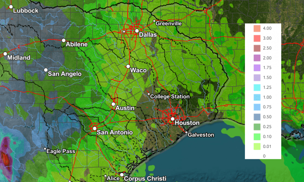
Rain amounts through sunrise Thursday are forecast to generally average around a half inch across the Hill Country. Isolated totals of 1-2 inches will be possible with some of the heavier downpours. Elsewhere, totals should generally average less than a quarter inch.
- High temperatures Wednesday will include the mid and upper 80s across the Hill Country, the mid-90s across Central Texas, and the low 90s across the coastal plains
For Thursday and Thursday Night
Forecasts call for another good chance for rain showers and scattered thunderstorms across the Hill Country, with the probability for rain remaining near 50 percent. There will be a 40 percent chance for additional showers and thunderstorms Thursday evening and Thursday night.
Meanwhile, a somewhat better chance for rain showers and thunderstorms is forecast for Central Texas compared to Wednesday, as the moisture plume is expected to bend further to the east. The probability for rain will be near 30-40 percent. Across the coastal plains, the probability for rain looks to remain near 20 percent.
Rain amounts Thursday through sunrise Friday are forecast to generally average around a half inch, with isolated higher totals. Across Central Texas, totals are forecast to average between a quarter and a half inch. Across the coastal plains, totals should average less than a quarter inch.
- High temperatures Thursday are predicted to be in the mid and upper 80s across the Hill Country, and in the low 90s at most other location
For Independence Day and Friday Night
A slight chance for rain showers and thunderstorms is forecast across the Hill Country, Central Texas, and coastal regions, with the probability s being near 20 percent.
- High temperatures are forecast to be near 90 degrees across the Hill Country, in the mid-90s across Central Texas, and in the low 90s across the coastal plains
NWS Rainfall Forecast Valid through 7 pm Friday:
Weekend Weather
Mostly sunny, warmer, and rain-free weather is forecast across the region as the ridge of high pressure spreads across Texas from the east.
- High temperatures are forecast to be in the low 90s across the Hill Country, with mid-90s across Central Texas and the coastal plains
Next Week
Mostly sunny, dry, and hot weather is forecast for next week as the subtropical ridge of high pressure (or heat dome) sets up over northern Mexico and the Desert Southwest. Temperatures will likely trend warmer throughout the week, with triple-digit readings possible by mid-week.
- High temperatures Monday and Tuesday are forecast to be in the mid-90s across the Hill Country, the mid and upper 90s across Central Texas, and mid-90s across the coastal plains
- High temperatures Wednesday through Friday are predicted to be in the mid to upper 90s across the Hill Country, near 100/101 degrees across Central Texas, and in the middle 90s towards the coast
The outlook for next weekend calls for continued dry weather with little change in the temperature.
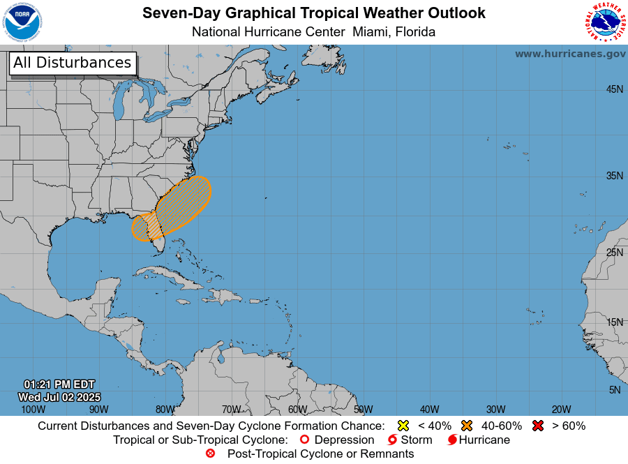
Tropical Weather Outlook
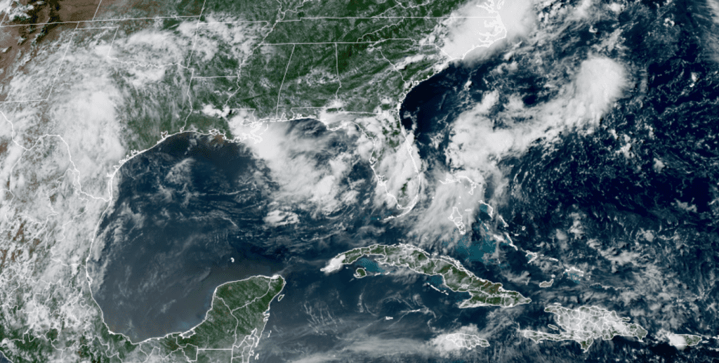
Weather conditions across the Gulf, the Caribbean Sea and the tropical Atlantic are currently very quiet.
National Hurricane Center forecasters are monitoring the southeastern U.S. Atlantic and eastern Gulf coasts where an an area of low pressure could develop by this weekend along a stalled boundary. Environmental conditions appear only marginally conducive for some slow development, but its possible a tropical or subtropical depression could form in this region over the weekend or early next week. Should a system develop, it is expected drift northward or northeastward, away from Texas.
NHC forecasters are giving this area a medium, or 40 percent, chance for tropical development over the next seven days.
NOAA/Colorado State University/RAMMB 07/02/2025 3:10 pm CDT
More Saharan Dust Expected Next Week
Another plume of light to moderately dense Saharan dust is forecast to arrive over South Texas Friday and spread inland to cover most of the state this weekend. Satellite images show this to be a rather large plume and it is expected to affect Central and South Texas through at least the middle of next week. It will likely cause a milky white sky and lower visibility.
Wishing everyone a safe and happy Independence Day and holiday weekend!
Bob
Social Media