Showers and Thunderstorms Returning for the Weekend. Pockets of Heavy Rain Possible
July 11, 2025
While it would appear our typical summertime weather pattern is trying to take hold, a chance for rain and thunderstorms will return to the forecast for Saturday and Sunday. Friday’s weather maps showed Texas being situated between ridges of high pressure centered over northwestern Mexico and just off the southeastern U.S. coast. A clockwise flow around the southeastern U.S. ridge is bringing moisture into the eastern half of the state. This weekend, a trough of low pressure dropping south into the southern Plains is expected to draw considerable moisture northwestward across Central Texas, the Hill Country and into West Texas. The weekend atmospheric setup appears favorable for the development of numerous rain showers and thunderstorms beginning in West Texas late Saturday, with the activity spreading southeast into the northern half of the Hill Country on Sunday. At the same time, scattered showers and thunderstorms are forecast to develop across the coastal plains region, with this activity expected to move northwest into parts of Central Texas. A dry and more summer-like pattern is forecast to take shape next week as the eastern ridge of high pressure spreads over Texas.
For Friday and Friday Night
Mostly sunny and dry weather is predicted for the Hill Country and Central Texas regions. For areas along and south of Interstate 10, there will be a 30 percent chance for scattered showers and thunderstorms. These rains should diminish around sunset. Totals should only average around a quarter inch. High temperatures are forecast to generally be in the low to mid-90s.
For Saturday
Across the Hill Country, forecasts call for a 30 percent chance for scattered showers and thunderstorms Saturday afternoon, with a 40-50 percent chance for showers and thunderstorms Saturday evening and Saturday night. Rain amounts through sunrise Sunday are forecast to average between 0.25 and 0.5 inches, with a few isolated heavier totals.
Across Central Texas, forecasts call for a 30-40 percent chance for scattered rain showers and thunderstorms Saturday afternoon and evening, with just a slight chance for rain after midnight Saturday night. Rain amounts through sunrise Sunday are forecast to average between 0.25 and 0.5 inches.
For the middle Texas coast, forecasts call for a 70 percent chance for showers and scattered thunderstorms Saturday morning through Saturday afternoon. The chance for rain looks to diminish Saturday evening. Totals through sunrise Sunday are forecast to around a half inch, with isolated higher totals.
High temperatures Saturday are predicted to be upper 80s to low 90.
For Sunday
A fairly widespread area of rain and thunderstorms is forecast to develop across West Texas early Sunday. Forecasts call for this activity to spread southeast into northern and western counties of the Hill Country Sunday morning through Sunday afternoon. Some of this rain could be locally heavy. Elsewhere, scattered showers and thunderstorms are forecast to increase in coverage Sunday afternoon.
For the Hill Country, there will be a 50 percent chance for showers and thunderstorms Sunday into Sunday evening. Rain amounts through sunrise Monday are forecast to average between 0.5 and 1 inch across the northern half, and be around a half inch across the southern half. Just a slight chance for rain is predicted for Sunday night.
Across Central Texas, there will be a 40-50 percent chance for scattered rain showers and thunderstorms Sunday afternoon into Sunday evening. Rain amounts through sunrise Monday are forecast to average between 0.25 and 0.5 inches.
For the middle Texas coast, there will be a 50-60 percent chance for showers and thunderstorms Sunday afternoon and Sunday evening. The rain should diminish late Sunday evening. Rain amounts through sunrise Monday are forecast to average between 0.25 and 0.5 inches
High temperatures Sunday are forecast to be in the low 90s.
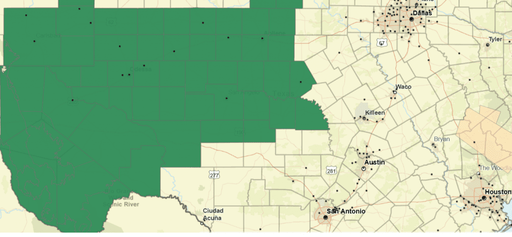
The National Weather Service has posted a Flood Watch for the northern Hill Country, the Concho Valley and all of West Texas from Saturday afternoon through Sunday afternoon. Parts of this area could see cumulative totals of 2 to 5 inches Saturday Night through Sunday. Isolated totals over 8 inches will be possible. With soils already still wet from recent rains, additional rain will quickly runoff, and possibly lead to flash flooding.
Flood Watch Saturday Afternoon through Sunday Afternoon for the Counties Highlighted in Green:
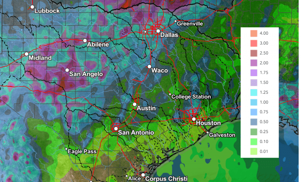
National Weather Service Rainfall Forecast Valid through 7 am Monday:
For Monday
There will be a 30 percent chance for afternoon showers and thunderstorms across the coastal plains region. Mostly sunny and dry weather is predicted for the rest of the region. High temperatures are forecast to be in the low and mid-90s.
Next Tuesday through Friday
Mostly sunny, dry, and warm weather is forecast across the entire region. Daily high temperatures are predicted to be in the mid-90s. Similar conditions are forecast into next weekend.
Tropicl Weather Outlook
Weather conditions are currently quiet across the tropical Atlantic and tropical cyclone development is not forecast for at least the next seven days.
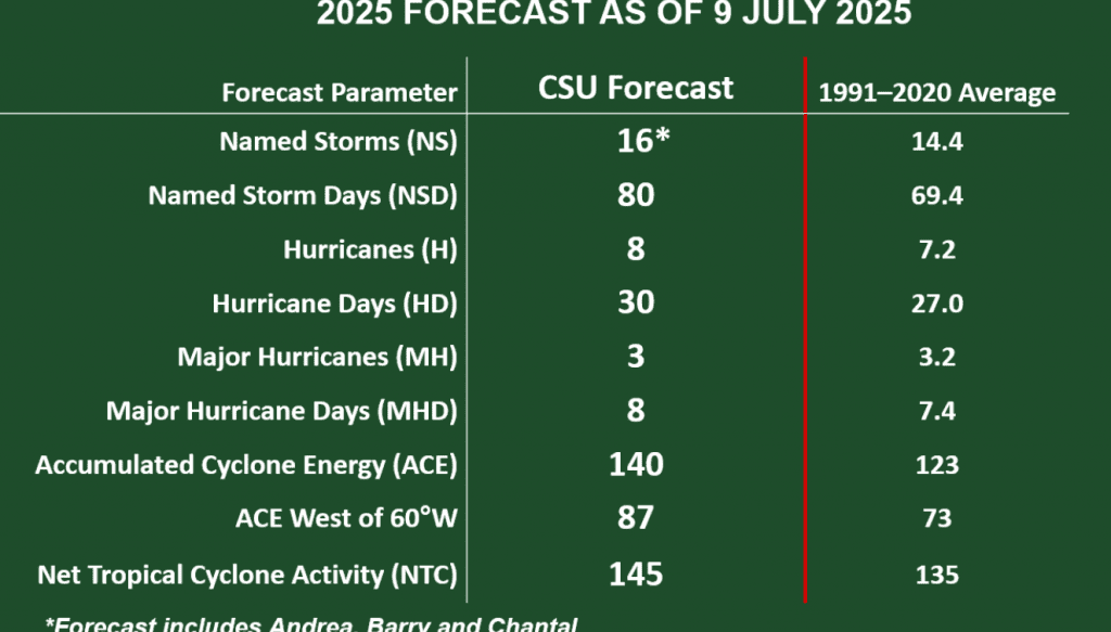
Klotzbach/CSU Team Lower Hurricane Numbers Slightly
On Wednesday, Phil Klotzbach and his forecast team at Colorado State University issued their July update for this year’s hurricane season. The updated outlook lowered the projected number of named storms slightly, from 17 to 16. The outlook calls for 8 hurricanes, with the possibility of 3 major hurricanes.
According to Dr. Klotzbach, the reason for the slight decrease in numbers is due to an observed southwest to northeast area of wind shear that is occurring across the Caribbean Sea. This belt of wind shear is forecast to continue at least trough August. Wind shear tends to dissipate developing and active storms. As of now, it’s unclear if this wind shear will continue through September and October.
Have a great weekend!
Bob
Social Media