Widespread Rain and Thunderstorms Forecast Late Wednesday through Thursday
NOV. 17, 2025
Unseasonably warm and humid weather will continue across our region through Wednesday. Southerly breezes with occasional gusts to 25 mph are forecast through the period. The moist flow off the Gulf will cause a pattern of late night and morning clouds, followed by a mostly sunny sky in the afternoon.
- High temperatures Monday and Tuesday are forecast to be in the mid and upper 80s
- High temperatures Wednesday are predicted to be in the mid-80s
- Lows temperatures Tuesday and Wednesday mornings will generally be in the mid and upper 60s
On Wednesday, the sky is forecast to remain mostly cloudy throughout the day as moisture increases ahead of a small trough of low pressure tracking northeast over Northwest Texas. With the atmosphere becoming increasingly moist and unstable out ahead of the trough, there will be chance for rain showers and scattered thunderstorms beginning Wednesday afternoon, continuing through Wednesday night. The probability for rain will be near 40 percent Wednesday afternoon and 50 percent Wednesday night. A few of the thunderstorms may be strong to severe—mainly over the Hill Country. The Storm Prediction Center has placed the Hill Country region under a Marginal Risk, or 1 out of 5 risk, for severe thunderstorms through 6 am Thursday. The primary severe weather threat is expected to be gusty downburst winds.
Rain amounts through 6 am Thursday are forecast to average around a half inch across the Hill Country, and around a quarter inch or less at most other locations
Widespread rain showers and scattered thunderstorms are forecast across the region Thursday into Thursday night when a vigorous trough of low pressure tracks from northeastern Mexico to the southern Plains. The trough is expected to cause the atmosphere to become increasingly unstable, resulting in the development of rain showers and thunderstorm clusters that will migrate from west to east. With an unusually moist atmosphere in place, a very efficient rain process is forecast. As of now, widespread severe storms are not expected, but a few of the stronger storms could produce damaging winds and large hail. The rain and thunderstorms are predicted to end from west to east Friday morning as the upper trough exits to the north. This will be followed by slightly cooler air.
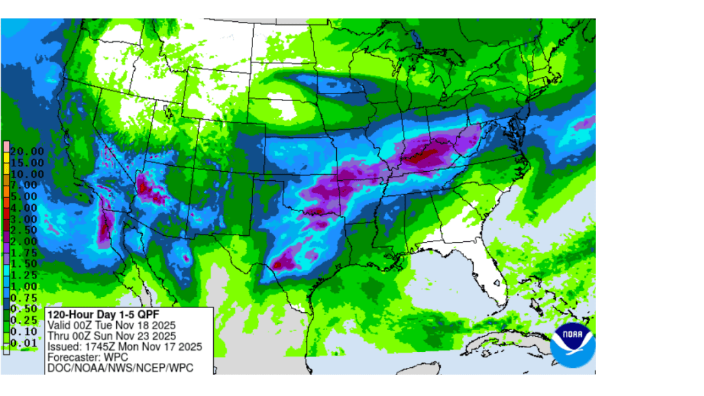
Rain amounts through Friday morning are forecast to generally average between 1 and 2 inches, with isolated totals to more than 3 inches possible. Depending on how fast the rain falls, these totals could pose a threat for localized flash flooding.
NWS Rainfall Forecast Valid through 6 pm Saturday:
Dry and slightly cooler weather is forecast Friday through Saturday in the wake of the departing storm system and Pacific cold front. High temperatures both days are predicted to be in the upper 60s to low 70s. Low temperatures Saturday and Sunday mornings will range from the upper 40s across the Hill Country, to the upper 50s across the coastal plains.
Forecasts call for another Pacific trough of low pressure to track from northeastern Mexico to the southern Plains states next Sunday and Monday. This system is expected to bring another period of rain and scattered thunderstorms to Central and South Texas on Sunday and Monday. Rain amounts from this system are not expected to be quite as heavy—generally averaging around a half inch. This will be followed by mostly sunny and dry weather next Wednesday through Friday. High temperatures next week are forecast to be in the 70s, with lows in the upper 50s.
Thanksgiving Day weather is shaping up to be sunny with a high temperature around 70-72 degrees.
Tropical Weather Outlook
Weather conditions remain quiet across the Atlantic and tropical cyclone development is not forecast over the next seven days.
Have good week.
Bob
Social Media