Temperatures Trending Milder Next Week. Little Rain on the Horizon
DEC. 5, 2025
A weak overrunning weather pattern produced widespread light rain across the region Thursday and Thursday night. Rain amounts across the Hill Country and Central Texas regions were quite low—generally less than a tenth of an inch. Across the middle Texas coast, totals were a bit higher and ranged between 0.25 and 0.75 inches.
Friday morning, the wave of low pressure responsible for Thursday’s light rain was pushing into East Texas, taking most of the rain with it. Some additional light rain showers will be possible for areas south of Interstate 10 through mid-afternoon Friday. Elsewhere, no additional rain is forecast. Friday morning’s satellite images showed a steady stream of middle and high-level clouds spreading across Texas out of northern Mexico. This area of clouds is predicted to be very persistent Friday afternoon through Friday night.
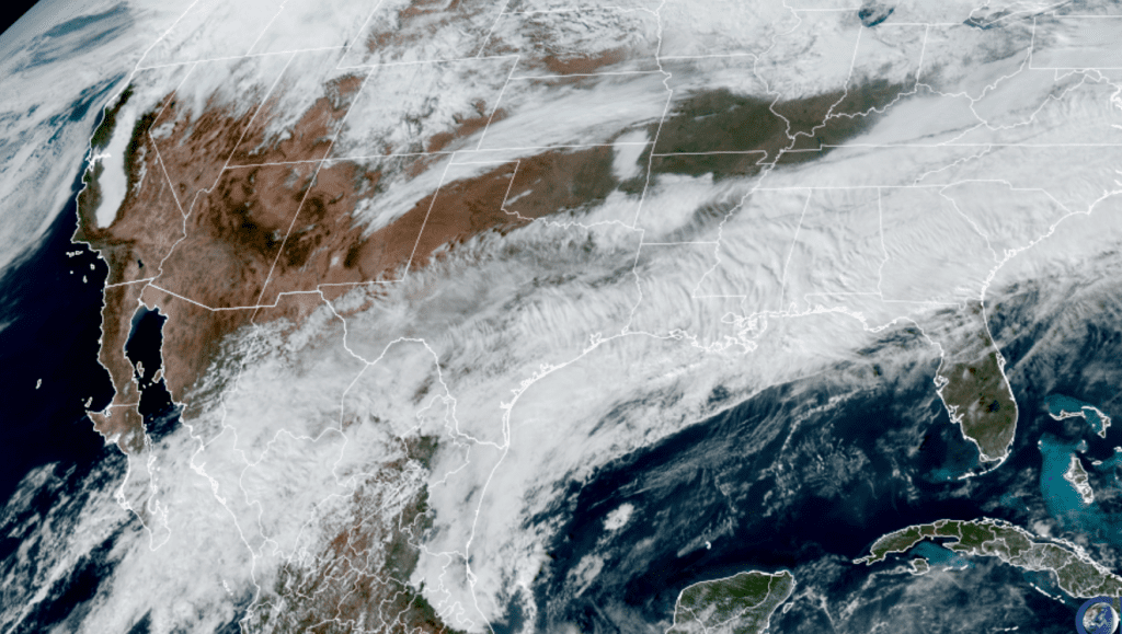
NOAA/Colorado State University 12/05/2025 2:00 PM CST
The area of clouds is forecast to diminish from west to east across the region Saturday morning as drier air finally works in from the northwest. A clear and sunny sky is forecast Saturday afternoon through Sunday night.
The temperature will trend warmer with the sunshine Saturday into Sunday, but a cold front pressing south across the area on Sunday will bring a blast of cooler air that will persist into early next week. Behind the front, expect a northerly breeze at 10-15 mph through Sunday night.
- High temperatures Friday will range from the upper 50s across the Hill Country, to the low 50s across the coastal plains
- High temperatures Saturday are forecast to be in the upper 60s to low 70s
- High temperatures Sunday will range from the low and mid-60s across the Hill Country, to the low 70s across the coastal plains
- Low temperatures Saturday morning will generally be in the low and mid-40s, with upper 40s expected towards the coast
- Low temperatures Sunday morning will generally be in the upper 40s to low 50s
- Low temperatures Monday morning will include the low and mid-30s across the Hill Country, the mid and upper 30s across Central Texas, and near 40-42 degrees across the coastal plains
Next week’s weather is shaping up to be sunny and dry as Texas comes under the influence of a broad ridge of high pressure covering the southwestern U.S. and northern Mexico. Expect mild daytime readings, with cool nights.
- High temperatures Monday and Tuesday are forecast to be near 60-62 degrees
- High temperatures Wednesday through Friday are predicted to be near 70-72 degrees
- Lows Tuesday morning will generally be in the mid and upper 30s
- Lows Wednesday through Friday mornings are forecast to be a mixture of low, mid, and upper 40s
Long Range Outlook
Forecasts call for a weak cold front to move across the area sometime late next week. A somewhat stronger cold front is predicted for some time next Sunday, bringing slightly cooler readings for the week of the 15th. Expect highs in the 60s, with lows in the 40s. No arctic air is forecast to spread into Texas over the next couple of weeks. The weather pattern is looking to stay dry over the next couple of weeks.
Where’s Venus?
You may have noticed the planet Venus is no longer visible in the early morning sky. Venus is the brightest planet visible from Earth. Venus left our morning sky a couple of weeks ago and is currently located in the bright glare of sunrise. Venus will remain out of sight over the next month as it moves behind the sun. Venus will emerge from behind the sun and enter the evening sky beginning in February 2026.
Have a great weekend!
Bob
Social Media