Coldest Temperatures So Far this Winter Expected Saturday Night
JAN. 16, 2026
Another surge of cold, Canadian air is on the way to Central Texas Friday afternoon and Friday night. Friday afternoon’s weather maps showed the cold front pressing south across Central Texas, with the front moving to the southeast quickly. The front is predicted to be off the coast Friday evening. Friday’s sky will remain sunny with no clouds or rain expected with the front. However, the front will cause an abrupt northerly wind shift with wind speeds increasing to 15-20 mph and occasional gusts to 30 mph. Similar wind speeds are forecast Friday night through Saturday afternoon. Lighter winds are expected Saturday night and Sunday. Cooler temperatures will follow the cold front Friday night. Then a second surge of even cooler Canadian air is predicted to spread south through the region Saturday afternoon that will set the stage for some very chilly temperatures Saturday night. A light freeze is forecast for all areas except for Matagorda County Sunday morning.
The gusty winds and very dry air will combine to produce near critical-to-critical fire weather conditions across the region Friday afternoon and again on Saturday. The NWS has posted a Red Flag Warning for Wharton the Hill Country and Central Texas regions along with Wharton and Matagorda Counties on Saturday. For more details, see the fire weather section below.
- Highs Friday will range from the upper 50s across the northern Hill Country, to the low and mid-70s across Central Texas and the coastal region
- High temperatures Saturday will include the low 50s across the Hill Country, with low and mid-50s at most other locations
- High temperatures Sunday will generally be in the low 60s
- Low temperatures Saturday morning are forecast to be in the low 30s across the Hill Country, in the mid and upper 30s across Central Texas, and in the low and mid-40s towards the coast
- Low temperatures Sunday morning will include the low and mid-20s across the Hill Country, the upper 20s across Central Texas, and near 30-32 degrees across the coastal region
- Lows Monday morning are forecast to be in the low and mid-30s across the Hill Country, with upper 30s at most other locations
Quiet weather looks to continue Monday and Tuesday. Forecasts call for another dry, Canadian cold front to move across the region Monday that will reinforce the cool temperatures already in place. The sky will be sunny Monday, but clouds are predicted to increase Monday night, with the sky becoming mostly cloudy on Tuesday.
- High temperatures Monday are forecast to be low and mid-60s
- High temperatures Tuesday are predicted to be in the low and mid-50s
- Lows Tuesday morning are forecast to be in the mid and upper 30s across the Hill Country and Central Texas regions, and in the mid-40s across the coastal plains
Changes in the weather pattern are forecast to take place Wednesday into Thursday when a trough of low pressure moves over Texas from northern Mexico and the Desert Southwest. The trough is expected to cause the development of an overrunning pattern that will bring a chance for light rain showers to the region Tuesday night through Wednesday night. Periods of light to moderate rain are forecast, with the most favorable area for rain expected to occur over the area along and east of Interstate 35. The probability for rain through the period is predicted to be near 40-50 percent.
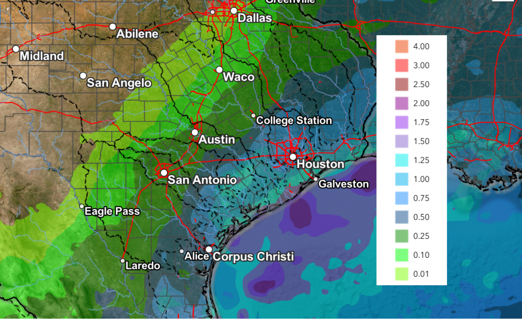
Rain amounts from this system through Wednesday night are forecast to range between a few hundredths across the Hill Country, to between 0.25 and 0.5 inches across Central Texas, to between 0.5 and 1 inch across the middle Texas coast.
NWS Rainfall Forecast Valid through 6 pm Next Friday:
Dry and mild weather is forecast next Thursday and Friday, continuing through next weekend. Expect high temperatures in the 60s to near 70 degrees, with lows generally in the 50s.
Looking out to the week of January 26th, we may see another chance for rain developing around the 26th, followed by dry weather for the remainder of the week. Temperatures look to trend a little cooler, with highs in the 50s and 60s, and lows in the 40s.
Fire Weather
Strong and gusty winds developing behind Friday’s cold front will combine with the very dry air to cause elevated to near critical fire weather conditions to develop across the Hill Country and Central Texas.
Critical fire weather conditions are forecast across the entire region Saturday due to gusty winds, low relative humidity levels, and very dry vegetation. The National Weather Service has posted a Red Flag Warning for the Hill Country all of Central Texas plus Wharton and Matagorda Counties from 10 am to 8 pm on Saturday.
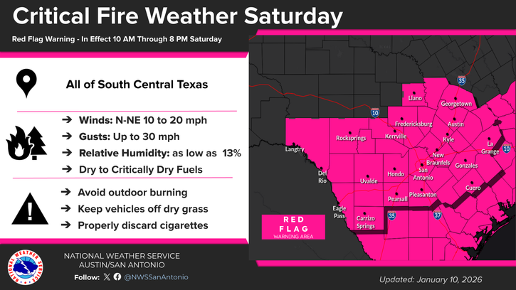
The fire weather threat is expected to decrease on Sunday as lighter winds develop.
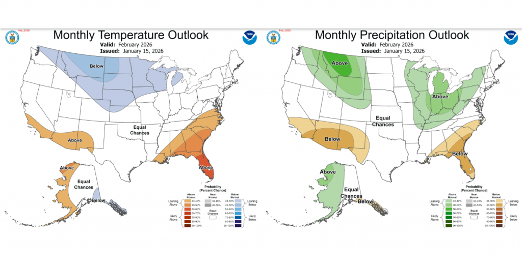
Update Outlook for February
On Thursday, NOAA’s Climate Prediction Center issued an update outlook for the month of February, showing little trend for temperature or precipitation. The outlook shows equal chances for above-, below-, or near-normal temperatures and rainfall. La Nina is predicted to rapidly weaken in February while additional shots of cold air are expected. Just how cold these shots will be is not clear at this time.
Have a great weekend!
Bob
Social Media