A Chance for Showers trough the Weekend. Dry and Warmer Weather Next Week
May 8, 2026
We’re looking at a fairly complicated weekend forecast as several weather features come together, possibly producing areas of rain and storms. While rain is forecast, the entire weekend is not expected to be a rainout. Sunday morning into Sunday afternoon (Mother’s Day) should be generally dry and sunny, before more rain and storms move in late in the day.
Friday’s weather maps showed an area of low pressure in the upper atmosphere located over northern Mexico, to the west of the Texas Big Bend. The low is forecast to track east, moving across Central and Southeast Texas Saturday afternoon. Weak atmospheric lift from the approaching trough is forecast to spread over the region Friday afternoon through about midday Saturday. With lift from this system being weak, widespread, or heavy rain is not anticipated. In addition, the threat for any severe storms will be quite low.
With the passing low pressure system, there will be a 20-30 percent chance for scattered rain showers and isolated thunderstorms across the region Friday afternoon through Friday night. The chance for rain and storms will increase to around 40 percent Saturday morning through early Saturday afternoon as the low moves overhead. The chance for rain will end from west to east Saturday afternoon as the trough exits the region. Clouds should decrease with the sky becoming mostly sunny Saturday afternoon. Expect warmer temperatures, with readings climbing to the mid-80s. Clear and quiet weather is predicted for Saturday night.
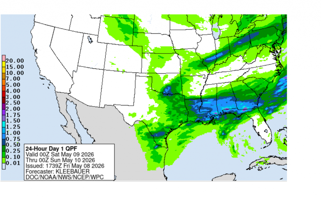
Rain Amounts
Totals through Saturday afternoon are forecast to generally average less than a quarter inch. A couple of isolated heavier totals will be possible across the coastal plains.
NWS Rainfall Forecast Valid through 7 pm Saturday:
Sunday and Sunday Night
There will be another chance for rain showers and thunderstorms Sunday afternoon into Sunday evening when a trough of low pressure drives a Canadian cold front south through the area. The front is predicted to reach the northern Hill Country about mid-afternoon, the Austin area in the late afternoon and early evening, and the coastal zone late Sunday evening. Forecasts are showing a favorable setup for an area of rain and thunderstorms to develop just ahead of and along the cold front as it makes its way south. In fact, some of these storms could be strong to severe. Storm Prediction Center Forecasters have placed all of Central Texas and the Hill Country under a Marginal Risk for severe thunderstorms through Sunday night. Large hail and damaging winds will be in the primary severe weather threats. The chance for rain should end shortly behind the cold front late Sunday evening. Rain amounts Sunday afternoon through Sunday evening are forecast to generally average between 0.25 and 0.5 inches, with isolated totals to near 1 inch possible. High temperatures Sunday are forecast to be in the mid and upper 80s.
Next Week
Sunny, dry, and quiet weather is forecast across the region next Monday through Friday as our region comes under the influence of a developing ridge of high pressure over northern Mexico and the southwestern U.S. This feature is predicted to bring an early season triple-digit heatwave to much of the Southwest and the southern Rockies early next week. Fortunately, the extreme heat is expected to remain to our west. High temperatures Monday and Tuesday are predicted to be in the mid-80s, warming to around 88-90 degrees Wednesday through Friday.
Longer-range forecasts do point to a chance for rain developing across our region next weekend as the ridge shifts up to the Midwest and a trough of low pressure pushes into the Desert Southwest.
No significant change in the temperature is forecast over the next ten days.
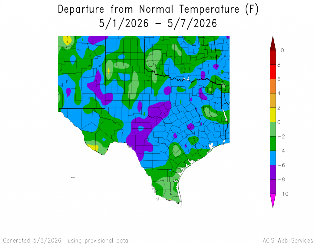
A Somewhat “Cooler” Start to May
The temperature for the first seven days of May has averaged between 4 and 6 degrees below normal across the region. A couple of cold fronts and periods of clouds have helped to keep the temperature down. Will these cooler temperatures last through all of May? It’s not likely, but unusually warm weather doesn’t appear to be on the horizon anytime soon.
Have a great weekend!
Bob
Social Media