Periods of Rain and Storms Forecast throughout the Week and through the Holiday Weekend
May 18, 2026
It’s shaping up to be a wet week across the entire region. Rounds of showers and thunderstorms are forecast to begin Tuesday and continue through late week and the holiday weekend. Locally heavy rain will be possible with each of the passing disturbances. Forecasts indicate large part of the area could see more than 5 inches of rain over the next seven days.
Monday Afternoon through Monday Night
No significant rain is forecast through Monday night. A moderate wind flow off the Gulf will cause a partly to mostly cloudy sky Monday afternoon, followed by overcast conditions Monday night. Expect southerly winds with gust to near 30 mph. Monday’s temperature is predicted to peak up near 88-90 degrees. Lows Tuesday morning will include the low and mid-70s across the Hill Country, with upper 70s at most other locations.
Tuesday and Tuesday Night
There will be an increasing chance for rain showers and thunderstorms developing across the Hill Country and Central Texas regions Tuesday afternoon through Tuesday night when a weak cold front sags to the south out of North Texas. High-resolution forecast models suggest showers and thunderstorms will blossom along and ahead of the cold front across North Texas during the day Tuesday, with the activity spreading south into the Hill Country and Central Texas regions beginning late Tuesday afternoon. Forecasters will also be monitoring West Texas where thunderstorms are forecast to develop along the dry line Tuesday afternoon and spread to the east. The area of rain and storms is predicted to sink south and spread over the middle Texas coast late Tuesday evening. Some of these storms along the cold front and also with the dry line may be strong to severe. The Storm Prediction Center has placed all the Hill Country along with the Austin and Interstate 35 corridor under a Slight Risk, or a 2 out of 5 risk, for severe thunderstorms Tuesday through Tuesday night. The rest of the region has been placed under a 1 out of 5 risk for severe storms. Large hail to near 2 inches in diameter and damaging winds up to 75 mph will be possible with some of the severe storms. For both regions, the probability for rain will be near 50 percent Tuesday afternoon, increasing to 80 percent Tuesday evening and Tuesday night. The chance for rain and storms is expected to decrease late Tuesday night as the storms exit the region and push offshore.
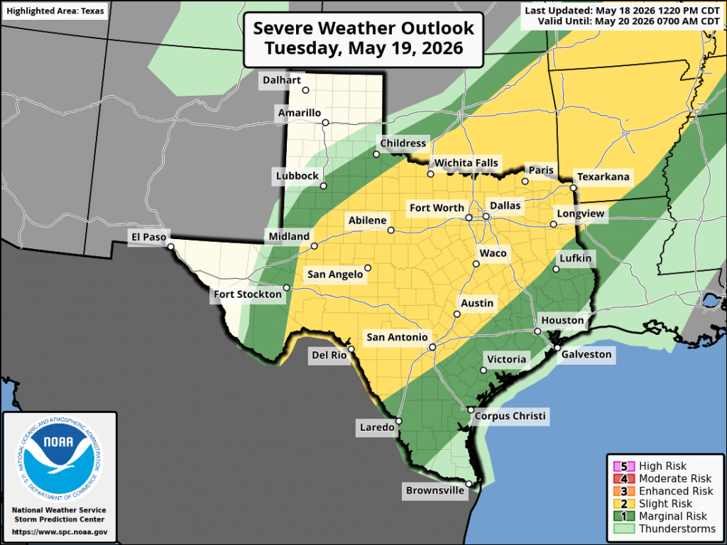
Rain amounts through daybreak Wednesday morning are forecast to generally average around an inch. Isolated pockets of 2-3 inches will be possible.
Wednesday through Thursday
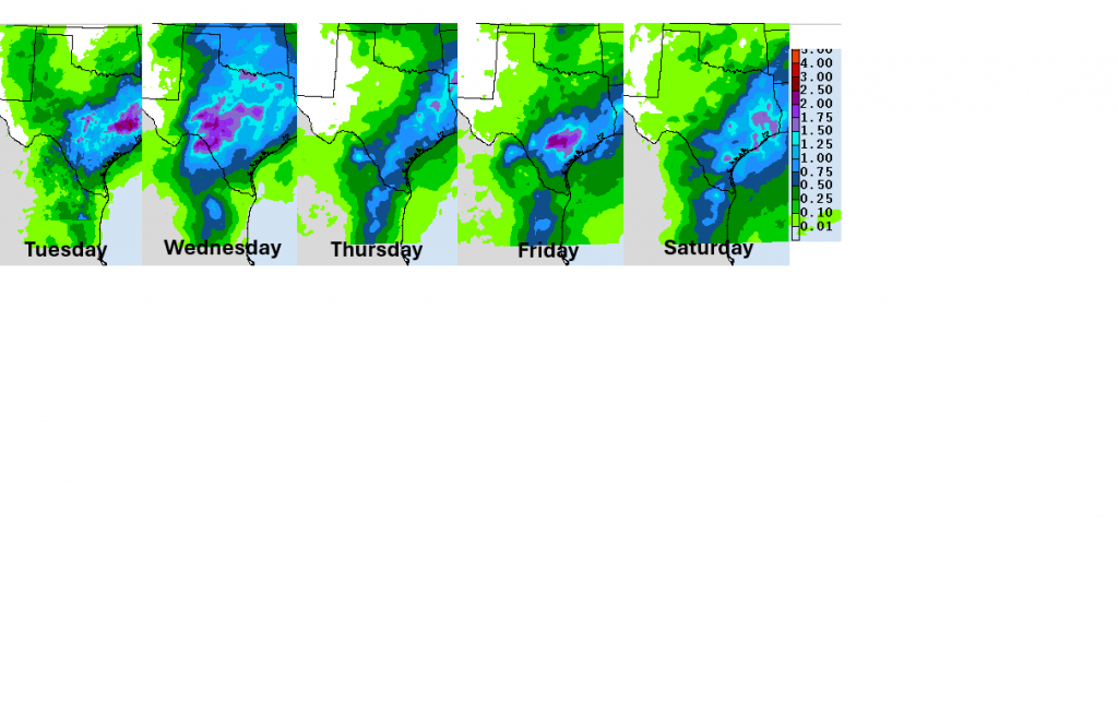
Wednesday’s weather will likely include a temporary lull in widespread rain following the passage of Tuesday night’s storms. However, a few showers and thunderstorms will be possible Wednesday afternoon and Wednesday night due to the stalled cold front and lingering moist air mass. The probability for rain will be near 50 percent. Rain amounts are forecast to average around a half inch.
The probability for rain showers and thunderstorms will increase Thursday as a wave of low pressure lifts northeast out of Mexico and tracks across Central Texas. At the same time, the cold front is predicted to remain stalled over the area. This setup is expected to support another round of widespread showers and thunderstorms. The severe weather potential will be limited, compared to what is expected Tuesday. Locally heavy rainfall is expected to be a greater concern. Rain amounts Thursday are predicted to average between 0.5 and 1 inch, with isolated heavier totals.
Friday through Memorial Day
Periods of rain showers and thunderstorms look to continue Friday through Monday as additional wave of low pressure move across Texas in a persistent southwesterly flow in the middle and upper atmosphere. The probability for rain each day is forecast to be near 70-80 percent. Each wave of low pressure is forecast to cause areas of rain and storms. Daily rain amounts are forecast to average between 0.5 and 1 inch. The severe weather potential should remain low late week into the weekend, with locally heavy rain and occasional lightning be the main concerns. Daily high temperatures are predicted to be in the low and mid-80s.
The Weather Prediction Center’s Daily Rainfall Forecast through Saturday:
Next Week
Forecasts indicate the wet and unsettled weather pattern will continue through late next week. Additional waves of low pressure are expected to spread over Texas through throughout the week, causing more periods of rain and storms.
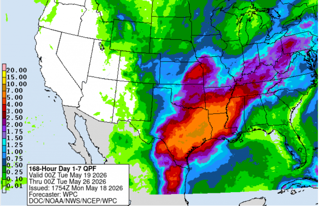
Forecast Totals Over the Next Seven Days
There will be a gradually increasing potential for flash flood and riverine flooding this week and into Memorial Day weekend as each round of rain saturates the ground further. Historically, the latter half of May has been famous for producing big totals of rain and oftentimes flooding. Please stay weather aware over the next several days!
The Weather Prediction Center’s cumulative seven-day rainfall forecast calls for widespread totals of 5-7 inches across most of the Hill Country, Central Texas, and middle Texas coast. Some totals in excess of 7 inches are indicated for the eastern counties of Central Texas.
Have a great week!
Bob
Social Media