Scattered Showers and Thunderstorms Developing Wednesday, Continuing through the Upcoming Weekend
June 1, 2026
As we kick off the month of June, our weather will be transitioning to a more summer-like pattern, featuring higher humidity levels and warmer temperatures. A chance for rain will enter the forecast Wednesday with additional chances for rain continuing through the upcoming weekend. Totals over the next seven days should average somewhere between 1 and 1.5 inches.
Monday’s weather maps showed a broad ridge of high pressure in the middle and upper atmosphere covering most of Texas and northern Mexico. Stable, sinking air from the ridge will cause generally dry and sunny weather across the region Monday afternoon through Tuesday. A Few spotty afternoon rain showers will possible across the coastal region on both days and especially on Tuesday as we see increasing moisture off the Gulf. In addition, forecasters will be monitoring the possibility for a few showers and isolated thunderstorms to develop along a cold front over East Texas Tuesday afternoon. These showers are forecast to spread to the southwest and have a slight chance reaching parts of Central Texas and the northern Hill Country Tuesday evening. Rain amounts through Tuesday evening should average less than a quarter inch. Warm and very humid conditions will be in place. High temperatures both days are predicted to be near 90-92 degrees. Lows are forecast to be in the low and mid-70s.
The chance for a more widespread coverage of rain showers and scattered thunderstorms will take shape Wednesday and continue through the upcoming weekend as the ridge over Texas weakens and a trough of low pressure moves into northern Mexico out of the Pacific. Weak waves of low pressure rotating around the main trough and spreading across Texas are expected to cause periods of rain showers and scattered thunderstorms through Sunday. The probability for rain looks to be near 50 percent Wednesday and Thursday. The probability for rain is forecast to increase to near 70 percent Friday through Saturday as the upper trough over Mexico shifts further east towards Texas. The probability for rain Sunday will lower to around 40 percent.
The atmospheric setup doesn’t look all that favorable for widespread severe storms, but a couple of isolated strong storms could produce strong winds and some hail.
The Weather Prediction Center’s Daily Rainfall Forecast Wednesday through Saturday:
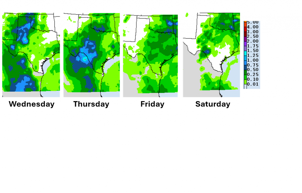
Total rain amounts through Saturday are forecast to generally average between 1 and 1.5 inches across the region:
WPC Rainfall Forecast Valid through 7 pm Saturday:

With an increased amount of cloud cover and periods of rain coming up, high temperatures Wednesday through Sunday are predicted to generally be around 88-90 degrees each day. Low temperatures will remain in the low and mid-70s.
Looking ahead to next week, forecasts call for a decreasing chance for rain early in the week as a ridge of high pressure begins to set up over southeastern U.S. and the Gulf of Mexico. The ridge will cause a sunny, dry, and warm weather pattern next week, with daily high temperatures predicted to be in the low and mid-90s.
Tropical Weather Outlook
Today marks the first day of the Atlantic hurricane season, which will run until November 30th.
Weather conditions across the tropical Atlantic, the Caribbean Sea and the Gulf of Mexico are currently quiet and tropical cyclone development is not expected over the next seven days.
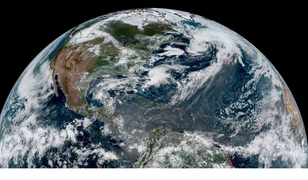
NOAA/Colorado State University/RAMMB 06/01/2026 12:20 pm CDT
Venus and Jupiter are Getting Closer Together
Tonight, after the sun goes down, go outside and look west. The two brightest planets, Venus and Jupiter, will be beautifully close together in the twilight sky. The two planets are converging for a tight conjunction on June 8-9. Watch the distance shrink every night this week.
Have a great week!
Bob
Social Media