Showers and Storms Increasing Late Sunday. Keeping an Eye on Developments in the SW Gulf
June 12, 2026
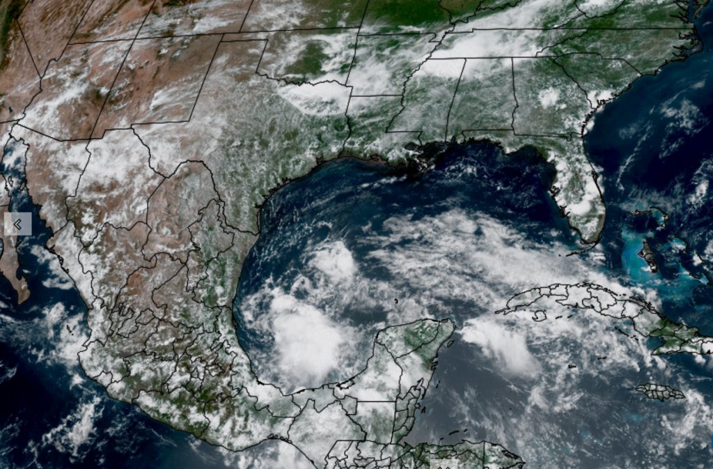
Starting off today’s brief with a look at weather conditions in the Bay of Campeche as conditions there may have some influence on Texas weather early next week.
National Hurricane Center forecasters are indicating a broad area of low pressure has formed over the far southern Bay of Campeche and the low is producing an area of disorganized showers and thunderstorms. Satellite images show a burst of deep convection has developed, but there are no indications a surface low pressure area developing. Environmental conditions are only marginally favorable for any development of this system given a good amount of westerly and southwesterly wind shear in place over the southern and western Gulf. NHC forecasters call for the system to move inland over eastern Mexico sometime late Saturday or Sunday. Given the marginal conditions in place, the probability for tropical development will only be 20 percent over the next few days.
NOAA/Colorado State University/CIRA 06-12/26 12:50 pm CDT
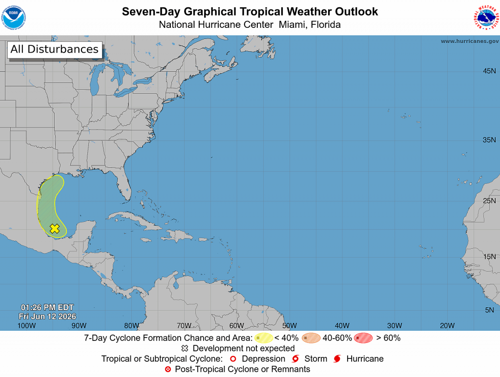
NHC points out the system could re-emerge over the northwestern Gulf on Tuesday and Wednesday while interacting with a frontal boundary. Because of this, the formation area (drawn in yellow on the outlook map above) extends north along the Texas coast. If the system does happen to re-emerge off the Texas coast early next week, conditions are expected to be only marginally conducive for tropical development.
Tropical moisture associated with this system is forecast to spread northwest toward the northern Mexican and southern Texas coasts over the weekend, then spread north along the Texas coast early next week. This enhanced area of moisture interacting with a cold front may help to produce heavy rainfall—especially across the coastal region.
Friday Afternoon through Sunday Afternoon
Partly cloudy and very summer-like weather is forecast Friday afternoon through Sunday afternoon as our region remains under a broad ridge of high pressure in the middle and upper atmosphere. High temperatures each day will generally be in the low 90s. Unusually high relative humidity levels will combine with the warm temperatures to produce peak heat index values of 100-105 degrees.
With considerable moisture in place, an isolated rain shower or thunderstorm will be possible on Friday and Saturday. The chance for rain at any given location will be less than 20 percent. Rain amounts, if any, should total less than a quarter inch.
Sunday Afternoon through Wednesday
The weather pattern will be changing late Sunday as the ridge of high pressure over Texas shifts southeast while a broad trough of low pressure develops south through the Plains states. This will allow for a rather strong cold front by mid-June standards to press south into Texas. Forecasts call for the front to reach the Interstate 20 corridor over North Texas Sunday afternoon and Sunday evening. The front is predicted to sink south across Central Texas late Sunday night into Monday morning and stall somewhere near Interstate 10 Monday afternoon and Monday evening.
Forecast guidance suggests a widespread area of rain showers and thunderstorms will develop ahead of and along the cold front as it sinks south through the region. The highest probability for rain and storms across Central Texas looks to be Sunday night through Monday. For the coastal region, the highest probability for rain will occur Monday through Tuesday.
Generally speaking, the probability for rain Sunday afternoon will be 40-50 percent, increasing to 60-70 percent Sunday night. The probability for rain Monday and Monday night will be near 80-90 percent, decreasing to 40-50 percent on Tuesday.
The threat for severe storms through this period will be low. Meanwhile, with abundant moisture in place, the threat for moderate to heavy rain and possible localized flash flooding will ramp up late Sunday and continue into early next week. The threat for heavy rain should taper off across the Hill Country and Central Texas regions Tuesday morning and across the coastal region Tuesday night.
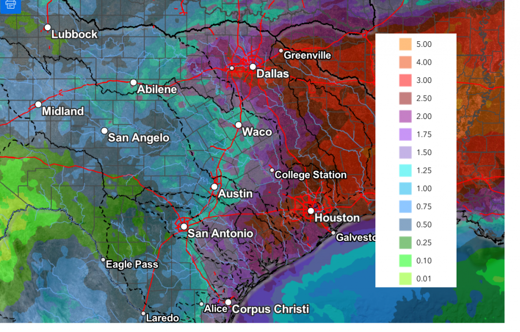
Rain amounts through Wednesday morning are forecast to generally average between 1 and 3 inches. Should that enhanced area of moisture from the tropical wave spread north up along the Texas coast, isolated total to near 5 inches will be possible—especially across the coastal plains region.
NWS Rainfall Forecast Valid through 7 pm Wednesday:
The outlook for late next week and next weekend is somewhat uncertain. Some of the forecast solutions indicate we could see another surge of tropical moisture into Texas late next week, while others are showing a return of the heat ridge. I’m leaning towards the drier and hot solution at this time, but conditions could change. Stay tuned.
Colorado State/ Phil Klotzbach Updated Hurricane Season Forecast
Thursday, Dr. Phil Klotzbach and his forecast team at Colorado State University issued an update to their seasonal hurricane season forecast. The update trimmed the number of storms that had been forecast in their April Outlook. The team now expects 11 named storms, five hurricanes, and two major hurricanes. This is down from their earlier prediction of 13 named storms and 6 hurricanes.
The primary reason for the downgrade is the development of El Niño conditions now and through the heart of hurricane season. El Niño tends to strengthen upper-level winds across the Caribbean and tropical Atlantic, increasing vertical wind shear that can disrupt developing tropical systems. The forecast team also noted that sea surface temperatures in portions of the eastern and central tropical Atlantic are running cooler than average, further reducing the odds of an especially active season.
The researchers are also forecasting a below-average probability of major hurricane landfalls in the United States and Caribbean. But they remind residents that preparedness remains essential because one storm can define an entire season for a community in its path.
Have a great weekend!
Bob
Social Media