Sunny and Hot Weather Expected through Weekend. An Isolated Shower or Two will be Possible
July 2, 2026
Hot temperatures and high humidity levels will be the primary weather factors we’ll be dealing with this Fourth of July weekend. A few brief, isolated rain showers or thunderstorms will be possible–mainly across the coastal region. However, most areas are forecast to stay rain-free.
Friday’s weather maps showed a broad ridge of high pressure, or heat dome, stretching from northern Mexico to the northeastern U.S. The most intense part of the heat dome was centered over the central Appalachians and is expected to bring intense, record-breaking heat to much of the eastern U.S. through Saturday. Fortunately, Texas will be on the western, less intense edge of the heat dome through the weekend. Sinking air underneath the heat dome will help to keep quiet weather in place through the weekend.
A very weak tropical wave, or area of low pressure, is currently situated over the northwestern Gulf and southwestern Louisiana, moving slowly to the west. This feature is expected to pull an area of tropical moisture inland across Southeast Texas and will result in the development of a few scattered rain showers and isolated thunderstorms—mainly for areas along and to the south of Interstate 10 through Sunday. Here, the probability for rain at any given location each day will be around 20-30 percent and rain amounts should average less than a quarter inch. A few of the showers could drift a little further inland up to the Interstate 35 corridor, but the chance for rain will be less than 20 percent. This activity will be driven by the heat of the day and any developing showers should dissipate by sunset.
Heat and humidity will be the main talking points this weekend thanks to the proximity of the heat dome.
- Daily high temperatures through Sunday are forecast to be in the mid to upper 90s across the Hill Country and Central Texas regions, and in the lower to mid-90s across the coastal region
Figuring in the high relative humidity levels that are in place, peak index readings are forecast to be in the range of 100-105 degrees.
If you plan to spend the day outdoors this weekend, make sure you wear light cloths, apply sunscreen, and stay hydrated by drinking plenty of water. Also take plenty of breaks from the heat by seeking shade and AC.
–Next Week–
Lingering tropical moisture is expected to cause the development of more spotty, brief rain showers and isolated thunderstorms across the coastal plains and parts of Central Texas on Monday. However, this small chance for rain looks to end on Tuesday. Forecasts call for heat dome over the eastern U.S. to weaken early next week, with the heat dome relocating to the southwestern U.S. and northern Mexico. Despite the changing position of the heat dome, sunny, dry, and hot weather looks to continue throughout the week.
Daily high temperatures are predicted to be in the upper 90s, with mid-90s across the coastal plains region.
Generally dry and continued hot weather is forecast for the week of July 13th.
Tropical Weather Outlook
Weather conditions remain very quiet across the tropical Atlantic, Caribbean Sea, and the Gulf. Atmospheric conditions remain unfavorable for tropical development over the next seven days.
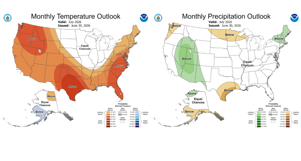
Updated Outlook for the Month of July
Earlier this week, NOAA’s Climate Prediction Center issued their first of the month updated outlook for July. The outlook shows increased odds the temperature will average above normal. For rainfall, the outlook leans toward below normal rainfall across the Hill Country, Central Texas, and coastal regions. The strengthening El Niño in combination with other atmospheric features are expected to keep the heat dome over our area throughout the month. This will result in continued hot weather and little rainfall.
I hope everyone has a safe and happy holiday weekend! Stay cool and drink plenty of water.!
Bob
Social Media