

The Heat Dome Will Produce Dry and Hot Weather throughout the Week
July 27, 2026
The dog days of summer have arrived across Texas. We’re looking at a stretch of hot, humid, rain-free weather this week and next. Monday’s weather maps showed a broad ridge of high pressure in the middle and upper atmosphere, or heat dome, covering the western and central U.S., with the dome centered over northeastern New Mexico. Sinking air under the heat dome is causing a very stable atmosphere along with a sunny sky and very hot temperatures.
Forecasts call for the heat dome to remain essentially stationary through Friday, so little change in the weather is expected this week.
The biggest weather news this week will be the heat:
- Daily high temperatures through Friday are forecast to be in the upper 90s across the Hill Country, in the mid and upper 90s across the coastal plains, and near 98 to 102 degrees across the Austin/Central Texas area
- Peak heat index readings Monday through Wednesday are forecast to be near 106 to 108 degrees across Central Texas, and between 105 and 110 degrees across the coastal plains region. The National Weather Service has posted a Heat Advisory for the coastal plains, including Fayette, Colorado, Wharton, and Matagorda Counties, through 7 pm Tuesday. This advisory may be extended for additional days this week
Please continue to keep heat safety in mind for any outdoor activities this week. Know the signs of heat-related illnesses, stay hydrated, and take frequent breaks from the heat. Also, remember to LOOK BEFORE YOU LOCK, and bear in mind that if the pavement is too hot for your palm, it is too hot for your pet’s paws.
This weekend into early next week, forecasts call for the center of the heat dome to shift west to Arizona and southern Utah. This will allow a trough of low pressure to develop across the Ohio and Tennessee Valleys, causing a very weak cold front to sink southwest into North and Central Texas Sunday into Monday. The front may be just strong enough to help produce a few widely scattered rain showers and isolated thunderstorms across Central Texas and the middle Texas coast Sunday into Monday. As of now, only spotty showers are forecast, with very low rain totals.
The outlook for next Tuesday through Friday calls for continued sunny, hot, and dry weather as the center of the heat dome remains near or just west of the Four Corners region . Daily high temperatures are predicted to generally hold in the upper 90s.
Tropical Weather Outlook
Weather conditions are quiet across the tropical Atlantic and tropical cyclone development is not expected over the next seven days.
Updated Outlook for August
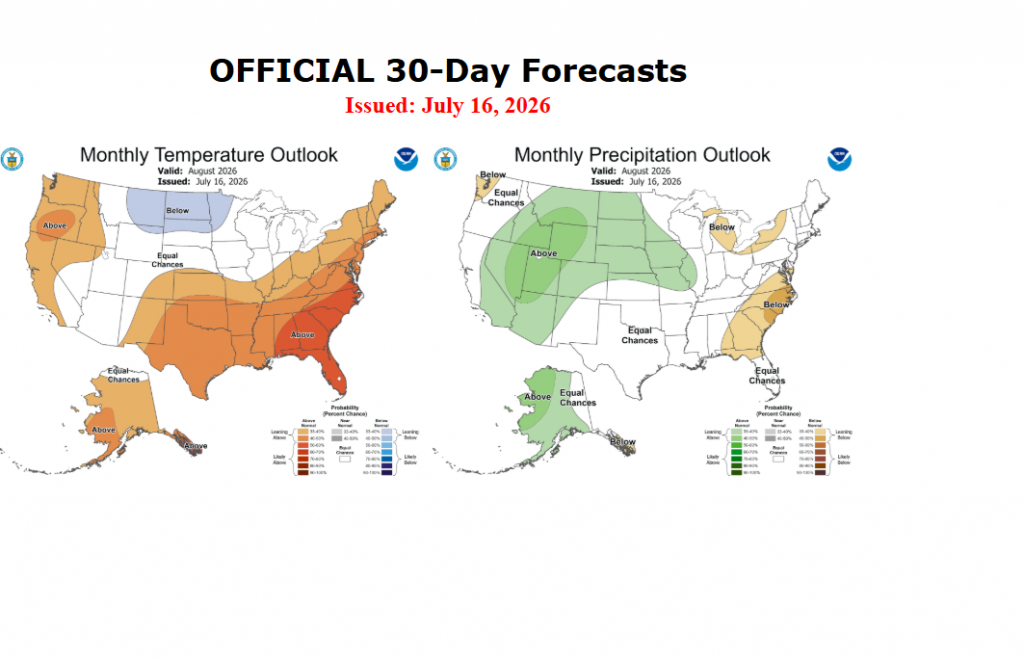
Late last week, NOAA’s Climate Prediction Center issued their monthly update for August. For Central Texas, the outlook leans toward above normal temperatures, with no clear trend for precipitation. The forecasters behind the outlook indicated there were mixed signals for precipitation for next month, with some solutions calling for above normal rain, while others called for little rain. The forecasters decided to take a middle of the road stance, showing little trend for above, below, or near normal rainfall.
The July full “Buck” moon will take place Wednesday morning at 9:36 am CDT. Because the full moon occurs during daylight hours across North America, the best time to view the full moon will be during the evenings of July 28 and July 29 as it rises in the southeastern sky after sunset.
Have a good week!
Bob
Social Media