

Triple-Digit Temperatures and Dry Weather Will Hang On into September
AUG. 28, 2026
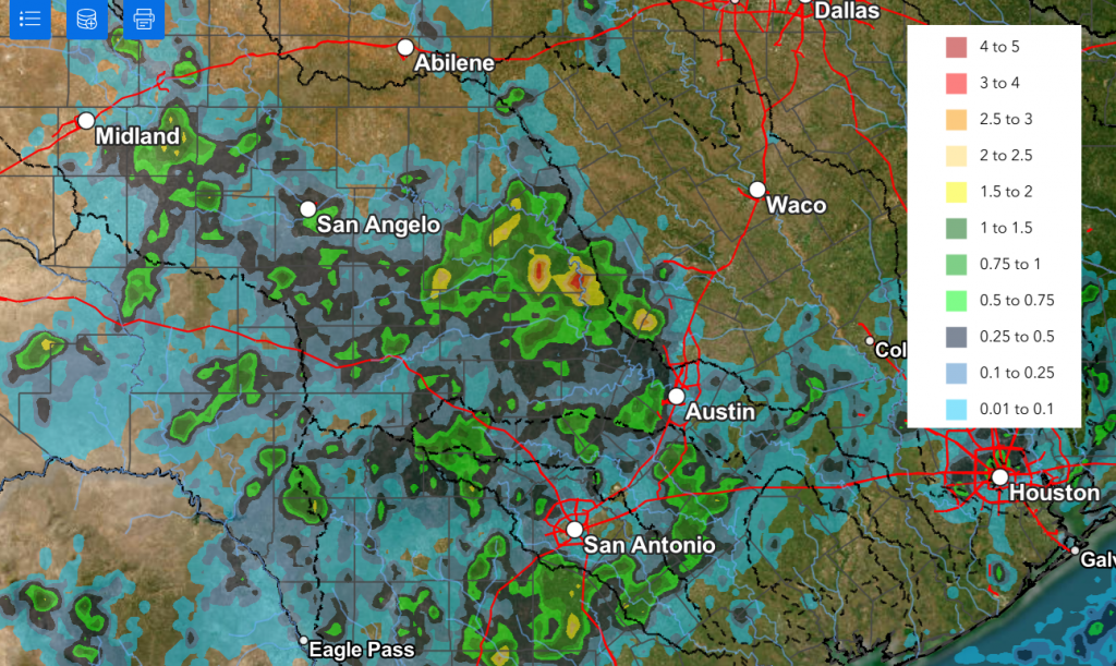
Rain showers and scattered thunderstorms developed across parts of the region Thursday afternoon and evening in response to a wave of low pressure dropping south out of North Texas. Some of the storms produced very strong winds with gusts to around 60 mph! The storms produced significant amounts of rain over the area between Austin, Llano, and Brady, where totals of 1-3 inches were observed. An LCRA Hydromet gauge located 11 miles north of Lake Buchanan measured a total of 3.55 inches. Across the remainder of the Hill Country and Central Texas, there were spotty totals of 0.25 to 0.5 inches. No rain was observed over the area south of Interstate 10.
Estimate of Rain Falling Between 7 am Thursday and 7 am Friday (Data courtesy NWS WGRFC)
There will be another chance for the development of scattered rain showers and thunderstorms Friday afternoon and evening—mainly for the area along and south of U.S. Highway 290. Here, remnant boundaries from Thursday’s activity along with a fair amount of atmospheric moisture will combine to produce scattered showers and storms. The most favorable are for rain looks to be across the coastal plains region, where the chance for rain will be near 40 percent. Across Central Texas, the probability for rain will be near 20-30 percent. A few of these storms may again produce strong and gusty winds. Friday’s rains are forecast to produce spotty totals between 0.25 and 0.5 inches, with isolated heavier totals.
Outside of this small chance for rain, Friday’s weather is shaping up to be mostly sunny and hot. High temperatures are forecast to be near 100-102 degrees across the Hill Country and Central Texas, and in the upper 90s across the coastal plains.
Sunny, dry, and very hot weather is forecast this weekend, continuing through late next week as our region remains under the influence of an unusually strong late summer heat dome. Forecasts call for the center of the heat dome to shift from Arizona to the southern Plains states this weekend, and to the middle Mississippi Valley region next week. The heat dome will be close enough to Central and South Texas to produce more sunny and very hot weather.
- Daily high temperatures Saturday through next Friday are predicted to generally be near 100-102 degrees across the Hill Country and Central Texas regions, and in the upper 90s across the coastal plains region. Peak heat index readings to near 107 degrees are forecast
One item to watch this week will be a weak tropical wave over the northern Gulf. Several forecast solutions indicate the wave will shift west to the upper Texas coast the second half of next week, bringing an enhanced area of moisture to southeast Texas. This moisture may result in the development of scattered showers across the middle Texas coast next Wednesday through Friday. As of now, significant totals of rain are not expected.
Looking out into the week of September 7th, the forecast solutions call for little significant change in the weather pattern across our region as the heat dome will persist across Texas. Little to no rain is forecast. Daily high temperatures are predicted to continue near 100 degrees.
Tropical Weather Outlook
Weather conditions remain very quiet across the Gulf of Mexico and the Caribbean Sea. Conditions look to remain unfavorable for tropical cyclone development for the next seven days.
In the tropical Atlantic, the system which had been Tropical Storm Dolly ran into a very hostile atmosphere overnight, causing the system to degenerate into an open tropical wave. The remnants of Dolly are forecast to continue moving to the west and spread across the Leeward Islands Saturday night into Sunday.
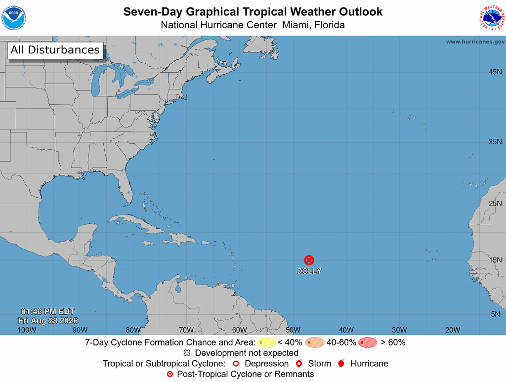
Elsewhere, there are no systems in place which pose a threat for tropical cyclone development over the next few days.
A Top Ten Warmest August
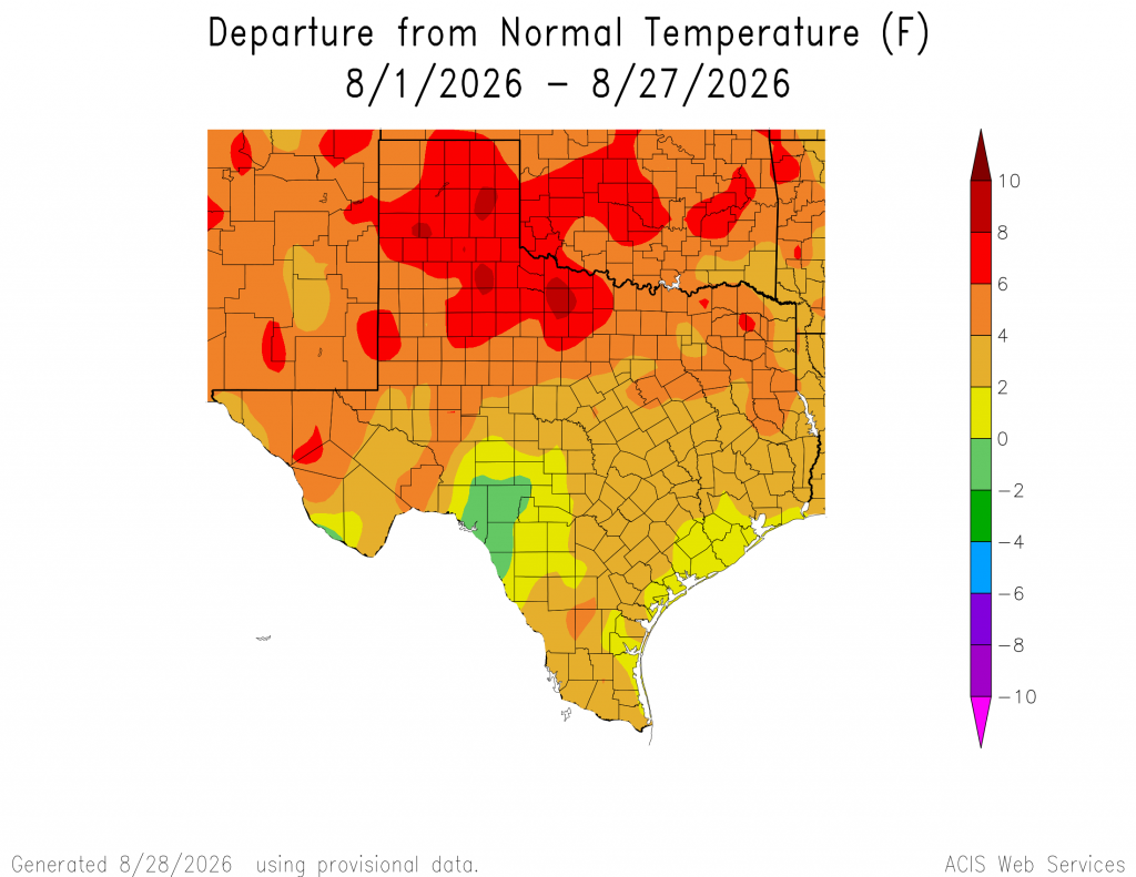
As everyone knows, temperatures this month have been way hot. Triple-digit temperatures have been observed on most days of the month. An analysis with data through the 27th shows the temperature has averaged between 2 and 4 degrees above normal across the region. That’s saying something when you’re talking about the hottest month of the year! In Austin, Camp Mabry’s temperature has averaged 89.6 degrees, which is 3.1 degrees above normal. The period of August 1-27 currently ranks as 5th hottest on record.
Have a great weekend! Stay cool and hydrated!
Bob
Social Media