

Wet Pattern Developing Thursday, Continuing through the Weekend
SEPT. 30, 2026
Wednesday’s forecast data continues to highlight the threat for heavy rain falling across the Hill Country and Central Texas regions late Wednesday night through midday Thursday, and for the coastal plains region late Thursday into Friday.
Wednesday’s analysis indicates the atmosphere over Texas had become quite moist and more unstable, compared to Tuesday. All eyes are on a trough of low pressure located over Arizona and New Mexico and its associated cold front. As of early afternoon, the front was located along the Texas/New Mexico border, extending southwest in to Far West Texas. The area along and just ahead of the cold front is expected to be the focus for the development of a large area of moderate to heavy rain when it pushes east from West Texas across the Hill Country and through Central Texas.
The cold front is expected to move very slowly to the east, causing the area of rain and thunderstorms to move slowly as well. Wednesday’s forecast solutions call for the cold front to reach the Concho Valley region Wednesday night, the Hill Country region Thursday morning, the Interstate 35 corridor Thursday night, and the coastal region on Friday.
- Showers and thunderstorms are forecast to develop ahead of and along the cold front across West Texas Wednesday night, then spread into the western Hill Country between midnight and 7 am Thursday
- The area of showers and storms are forecast to spread east across the eastern Hill Country and the Interstate 35 corridor early Thursday morning through early Thursday afternoon
- The area of rain and storms is forecast to move over the area between Smithville and Columbus early through late Thursday afternoon
Some of the rain within this area could be locally heavy, producing high totals in a short period of time. Behind the initial line of rain and storms, periods of light to moderate rain look to continue across the Hill Country and Central Texas regions Thursday afternoon through Thursday night. Periods of showers and thunderstorms are forecast across the middle Texas coast Thursday night into Friday morning.
Keep in mind some of the thunderstorms with this initial line could be strong to possibly severe. The Storm Prediction Center has placed the Hill Country and Central Texas regions under a 1 out of 5 risk for severe storms through Thursday night. Severe weather threats will include large hail, damaging downburst winds, and an isolated tornado or two.
For Friday, periods of moderate rain and a few isolated thunderstorms are forecast across the region as a piece of the upper trough hangs back across the southern Rockies. The probability for rain Friday will be near 90 percent, decreasing to 70 percent Friday night.
The National Weather Service has posted a Flood Watch for the Hill Country and Central Texas regions through Friday evening.
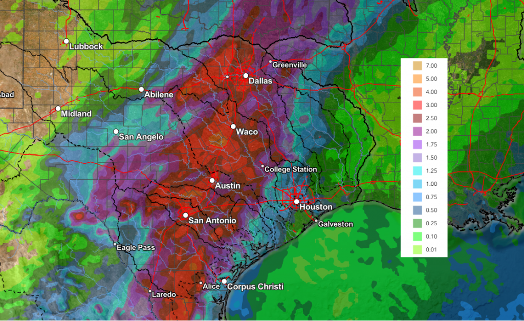
Rain amounts through 7 pm Friday across the Hill Country and Central Texas regions are forecast to generally average between 1 and 4 inches, with isolated totals of 6-8 inches possible. For the coastal region, totals of 1-3 inches are forecast.
NWS Rainfall Forecast Valid through 7 pm Friday:
Saturday through Sunday, periods of light to moderate rain are forecast as an overrunning pattern sets up across the region. The probability for rain both days looks to be near 50-60 percent. Additional rain amounts of 0.5 to 1 inch are predicted through Sunday. The chance for rain is forecast to diminish on Monday, with sunny and dry weather following for the remainder of next week.
High temperatures this weekend through late next week are forecast to mainly be in the low and mid-80s, with lows in the upper 60s.
Bob
Social Media