

Summer-Like Heat and Humidity Returning for Next Week
OCT. 9, 2026
Hints of autumn showed up this week as overnight temperatures dipped into the 50s and 60s. Meanwhile, afternoon readings have still been somewhat summer-like. This week’s pleasant morning temperatures resulted from significantly drier air spreading into Texas behind last weekend’s cold front. The drier air is still in place and will allow for more pleasant overnight temperatures Friday night and Saturday night. but a return of southerly breezes this weekend looks to bring back humid and sticky weather next week.
- Lows Saturday morning will include the upper 50s to low 60s across the Hill Country and the mid-60s at most other locations
- Lows Sunday morning are predicted to be in the mid and upper 60s
expected Major Hurricane Isaias is forecast to make landfall across the western Florida Panhandle late Friday, with the storm having little to no impact on our region’s weather. Sunny and quiet weather will be in place across Texas this weekend thanks to a broad ridge of high pressure in the upper atmosphere covering the south-central U.S. Weak east-northeasterly breezes Friday will become southerly on Saturday. Wind speeds are forecast to increase to 10-15 mph, with gusts to 25 mph on Sunday. Sunday’s onshore breezes will bring a return of moisture and higher humidity levels.
- High temperatures Friday through Monday are forecast to include the upper 80s across the Hill Country and the low 90s across Central Texas and the middle Texas coast
For next week, our weather looks to have more of a summer-like feel as warm, breezy, and humid weather holds through Thursday. A large trough of low pressure pushing inland along the West Coast this weekend is forecast to track into the southwestern U.S. Tuesday and Wednesday. In advance of the trough, a moderate flow off the Gulf is expected to bring increasing levels of moisture to much of the state.
Monday through Wednesday, expect a mostly sunny to partly cloudy sky with breezy conditions across the region. There will be a slight chance for a few scattered afternoon rain showers and thunderstorms across the coastal region on all three days. Most other locations should stay dry.
- High temperatures Tuesday and Wednesday are forecast to generally be in the low and mid-90s
The chance for scattered rain showers and thunderstorms will increase across the region Thursday when a cold front connected the southwestern trough begins to push into West Texas. Widespread rain shows and scattered thunderstorms are forecast Friday into early Saturday as the cold front pushes east across Central and East Texas. The rain is forecast to taper off from west to east next Saturday.
Noticeably cooler temperatures will follow the cold front beginning next Friday, continuing through next weekend. High temperatures are predicted to fall into the 70s, with low temperatures generally in the 50s. Much of the Hill Country will likely see lows in the upper 40s next weekend. These more fall-like temperatures are forecast to continue into the week of October 19th.
Tropical Weather Outlook
All eyes are currently on Hurricane Isaias. There are no other systems across the tropical Atlantic which pose a threat for tropical development over the next seven day.
As of 2 pm Friday, the center of Major Hurricane Isaias was located about 125 miles south of Pensacola, Florida. Maximum sustained winds were near 120 mph with higher gusts. Isaias is a category 3 hurricane on the Saffir-Simpson Hurricane Wind Scale. Fluctuations in intensity are possible through this afternoon, but Isaias is expected to be at or near major hurricane strength when it makes landfall this evening. Weakening is expected beginning Friday night after Isaias makes landfall, and the storm is likely to become post-tropical by late Saturday.
Data from NOAA and Air Force Reserve Hurricane Hunter aircraft indicate that maximum sustained winds remain near 120 mph with higher gusts. Isaias is a category 3 hurricane on the Saffir-Simpson Hurricane Wind Scale. Fluctuations in intensity will be possible through Friday afternoon, but Isaias is expected to be at or near major hurricane strength when it makes landfall Friday evening. Weakening is expected beginning Friday night after Isaias makes landfall somewhere over the western Florida Panhandle. The storm is likely to become post-tropical by late Saturday.
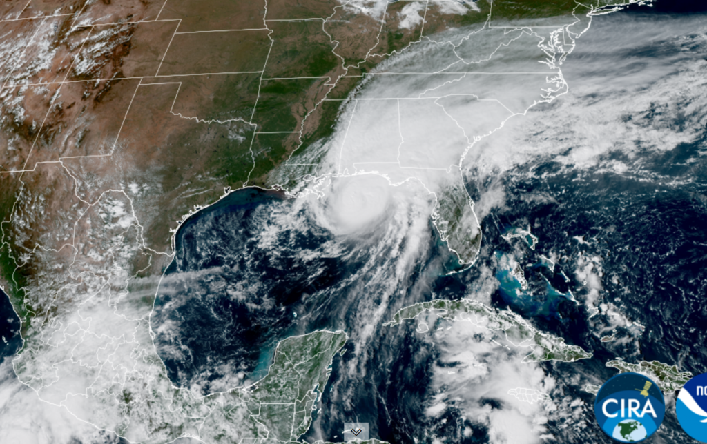
NOAA/Colorado State University/CIRA 10/09/2026 2 pm CDT

Have a great weekend!
Bob
Social Media