

Chances for Rain Increasing Late Week
OCT. 26, 2026
After numerous days of sunny, benign weather, changes in the weather pattern are beginning to take place across Central and South Texas. The unusually strong ridge of high pressure that has been over the state for the past week has now shifted east to the Lower Mississippi Valley. At the same time, a broad trough of low pressure has recently taken shape across northern Mexico and the western U.S. This trough is forecast to remain to our west throughout the week and into the upcoming weekend, allowing for smaller troughs and disturbances to track further to the east and northeast. This should finally bring a chance for rain to much of the area late week.
On this Monday, one of those smaller troughs of low pressure is tracking northeast from southeastern New Mexico to the Texas Panhandle . This system is bringing a large area of light to moderate rain to northwest Texas and the Panhandle region. All the rain is expected to remain well to the north of the Hill Country and Central Texas regions Monday afternoon and Monday night. The system is pulling quite a few clouds north out of Mexico, resulting in a partly to mostly cloudy sky. Monday’s high temperature will range from the upper 70s across the Hill Country, to the mid-80s near the coast. Lows Tuesday morning will generally be in the low and mid-60s.
The trough of low pressure over the Panhandle is forecast to lift northeast to the Plains states on Tuesday. For the southern half of the state, a moist Gulf flow is expected to increase Tuesday into Wednesday. This may result in a few scattered showers on both days—mainly for areas to the south of Interstate 10. Elsewhere, the sky looks to be partly cloudy. Tuesday’s temperature is predicted to generally reach the low 80s.
Wednesday night into Friday, the chance for scattered rain showers and isolated thunderstorms will increase across the region as another small wave of low pressure begins to track northeast out of northwestern Mexico. Forecasts call for the atmosphere to become quite moist across Texas out ahead of this system—particularly across the western half of the state. The increased moisture combined with atmospheric lift from the approaching trough will cause the chance for rain to increase beginning Wednesday night and continue Thursday through Friday.
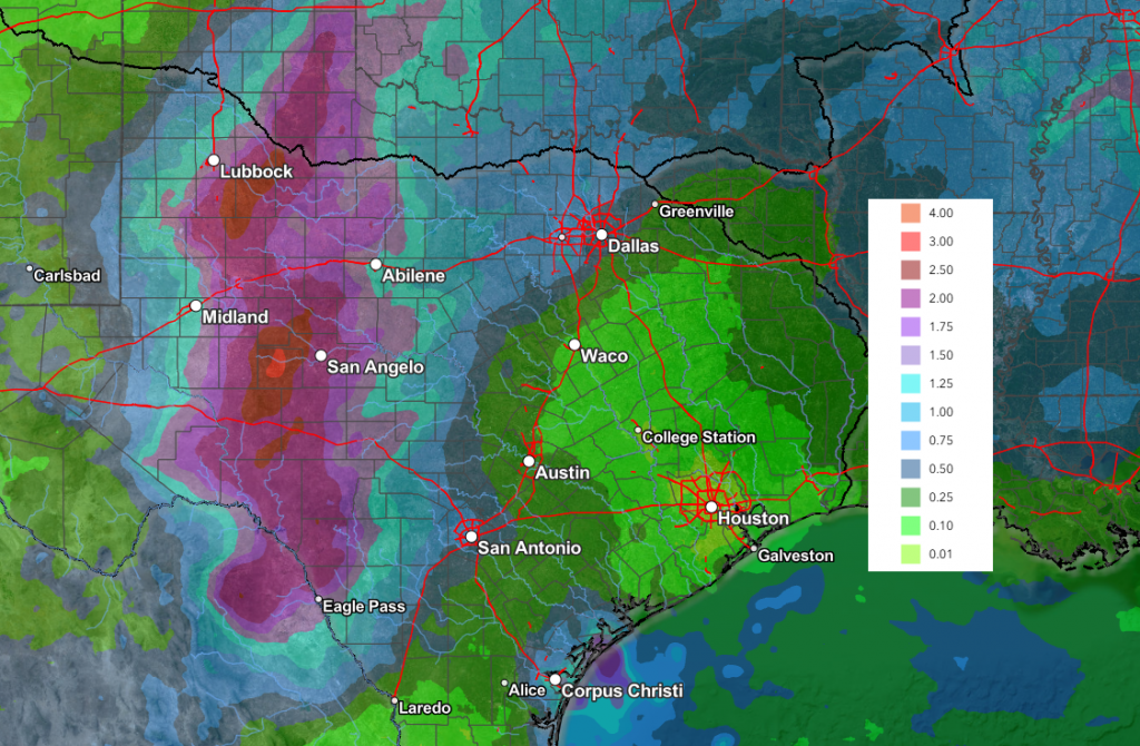
The most favorable atmospheric conditions for rain and scattered thunderstorms are forecast to be across West Texas, generally over the area from Eagle Pass to Midland/San Angelo, to near Childress. This is where the highest amount of atmospheric moisture will likely be in place. High chances for rain are also forecast across the Edwards Plateau and into the western Hill Country where 2-day totals are predicted to be between 1 and 2 inches. Some locally heavy rain will be possible as waves of rain move over the area. Further to the east across Central Texas, the chance for rain is forecast to be near 40-50 percent Thursday through Friday. Totals here are predicted to be quite a bit lower, more in the range of 0.25 to 0.5 inches. Strong to severe storms are not expected. Towards the coast, the chance for rain is forecast to only be around 20 percent.
Here’s a day-by-day breakdown forecast of the rain from the National Weather Service:
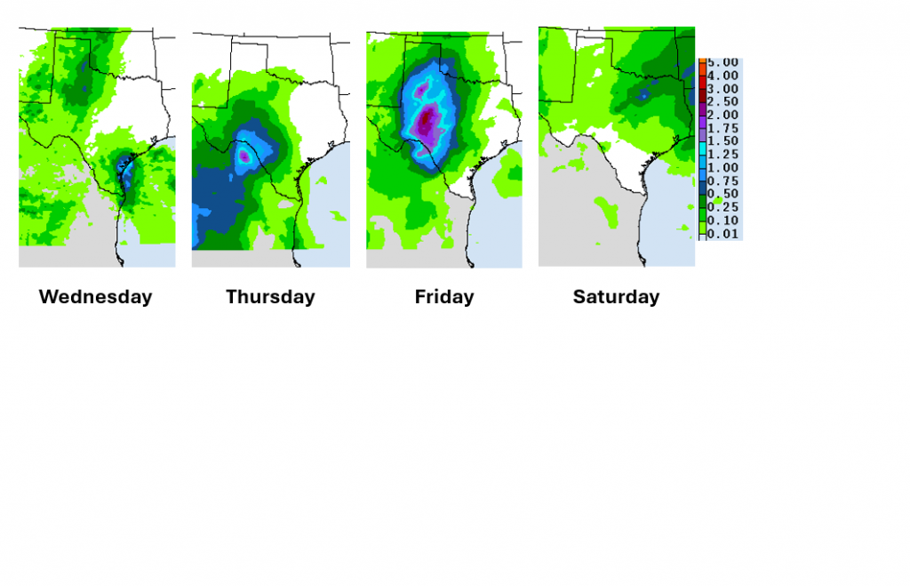
A few light showers are forecast to continue Friday night through about mid-afternoon Saturday as s the trough slowly lifts up to the northeast. Rain amounts are not expected to be very heavy.
NWS Rainfall Forecast Valid through 6 pm Monday, 11/2:
High temperatures Thursday through Saturday are predicted to generally be around 78-80 degrees, with lows in the upper 50s to low 60s.
Saturday evening and Saturday night’s weather is shaping up to be partly cloudy and dry. The temperature is predicted to generally be in the low 70s through the evening. Lows Sunday morning are forecast to be in the upper 50s to low 60s.
Mostly sunny and dry weather is forecast next Sunday and Monday. High temperatures are predicted to be in the mid and upper 80s.
Next week, a Pacific cold front is forecast to push southeast across the area sometime late Tuesday into Wednesday. A chance for rain showers and thunderstorms is forecast to develop across the region along and ahead of the cold front. Rain amounts are not expected to be very heavy—mostly in the range of a quarter inch. Dry and slightly cooler weather will follow the cold front late Wednesday through next Friday. Daily high temperatures are predicted to be in the upper 70s, with lows mostly in the mid and upper 50s.
Tropical Weather Outlook
Weather conditions are quiet across the tropical Atlantic. There are no systems in place which pose a threat for tropical development over the next seven days.
Time Change Weekend
Saturday night is Halloween, but it’s also time change. Daylight saving time will end at 2 am Sunday morning, Nov. 1. At the time, we will “fall backward” and set our clocks back one hour. The change marks the return to standard time and gives Americans an extra hour of sleep. It also brings earlier sunsets and more morning daylight as winter approaches. Under current law, daylight saving time begins on the second Sunday in March and ends on the first Sunday in November.
Bob
Social Media