

Widespread Rain Expected Sunday into Monday. Fall-Like Temperatures to Continue
NOV. 6, 2026
We’re looking at a cloudy, cool, and wet weekend across the region as an overrunning pattern develops ahead of an approaching trough of low pressure. This trough is embedded within the subtropical jet stream that currently stretches from the eastern Pacific to the southeastern U.S. The subtropical jet stream is a product of this fall’s very strong El Nino and the jet is expected to be a frequent feature over our area throughout the upcoming winter. In other words, we’re likely to see more of these cloudy, wet, and cool periods in the months ahead.
Friday’s weather will feature a partly cloudy sky and slightly cooler temperatures. A weak cold front moved through the area late Thursday night and has brought with it some slightly cooler air that will continue through the weekend. Meanwhile, clouds will be on the increase Friday evening, with the sky becoming mostly cloudy by about midnight.
- High temperatures Friday will include the mid and upper 60s across the Hill Country, the low and mid-70s across Central Texas, and the upper 70s to low 80s across the coastal plains
- Lows Saturday morning will range from the low 50s across the Hill Country, to the low 60s near the coast
Our weather will begin to change on Saturday when a vigorous trough of low pressure riding along the subtropical jet sinks south from the Desert Southwest into northern Mexico. The approaching trough is expected to pull considerable moisture from the Pacific and the Gulf up and over the cool air mass in place across Texas. As atmospheric lift increases Saturday afternoon, an overrunning pattern of clouds and light to moderate rain is forecast to develop. High resolution forecasts call the weather to stay dry across our region through Saturday morning. A few light rain showers are predicted to begin developing across the Rio Grande Plains and the Edwards Plateau shortly after noon, with some of the activity spreading east through the Hill Country and up to the Interstate 35 corridor Saturday afternoon.
Forecasts call for a widespread area of light to moderate to develop across the Hill Country Saturday evening, with the area of rain expanding east across Central Texas and the middle Texas coast Saturday night, continuing throughout the day on Sunday and Sunday evening. The probability for rain will be near 50-60 percent.
There will be a 30 percent chance for some lingering showers across the region Monday as the main trough finally lifts off to the northeast. However, a small trough hanging west across Mexico is expected to bring a few more light showers to the region Monday night into Tuesday morning. The chance for rain will again will near 30 percent. The chance for rain should diminish across the entire region by Tuesday afternoon as both troughs exit the area.
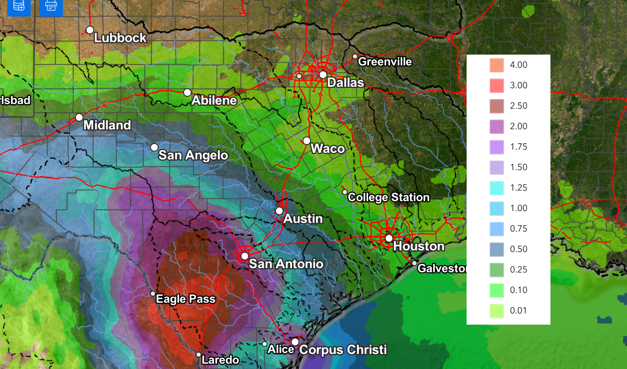
Totals from the rain this weekend and early next week are predicted to be heaviest across the Edwards Plateau, the Rio Grande Plains, and southwest Texas in association with more available moisture. Amounts through Tuesday are forecast to generally average between 1 and 2.5 inches across the Hill Country. In the Austin/Central Texas area, totals are forecast to generally average between 0.5 and 1 inch. And towards the coast, totals are predicted to average just under a half inch.
NWS Rainfall Forecast Valid through 6 pm Wednesday:
Temperatures will feel cool over the next few days.
- High temperatures Saturday will range from the low 60s across the northern Hill Country, to the low 70s near the coast
- High temperatures Sunday and Monday are forecast to be in the low and mid-60s
- Lows Sunday through Tuesday morning are predicted to be in the low and mid-50s
Clouds are forecast to clear Tuesday afternoon. Sunny and dry weather is predicted next Wednesday through Friday. Expect daily high temperatures to generally be in the mid-70s, with lows in the low and mid-50s. Long-range forecasts indicate a slight chance for rain will return to the forecast next weekend.
Tropical Weather Outlook
Weather conditions remain quiet across the Gulf, the Caribbean Sea, and the tropical Atlantic. Tropical cyclone development is not expected across these areas over the next seven days.
Across the western and central Atlantic, a non-tropical low pressure area is located several hundred miles south of Bermuda, producing limited shower activity. NHC forecasters state the chances of this low acquiring subtropical characteristics are decreasing due to strong upper-level winds that are expected to persist over the system into the weekend. The low is forecast to move generally eastward over the western and central subtropical Atlantic during the next couple of days and become absorbed by a new non-tropical low pressure system to its east later this weekend.
NHC places the chances for tropical development at only 10 percent over the next seven days.
Have a great weekend!
Bob
Social Media