A Chance for Rain and Storms Tuesday and through Wednesday Morning. Turning Cooler Thursday
March 9, 2026
An area of rain and thunderstorms spread across the region Saturday into Sunday along and behind a cold front. Unfortunately, rain amounts turned out to be much less than were forecast—mainly due to the lack of atmospheric instability. Totals generally ranged between a tenth and a half inch at most locations. The highest totals occurred across the northern Hill Country where amounts averaged just over an inch. The highest gauged weekend total across the region red along the coast, in southeastern Matagorda County, where an LCRA gauge near Sargent recorded 2.81 inches.
There will be one more opportunity for rain this week before the weather pattern trends back to dry for an extended period. Monday’s weather maps showed an area of low pressure in the upper atmosphere located just off the northern coast of Baja, California. The low pressure area is forecast to get picked up by the jet stream and pulled across Texas late Tuesday through Wednesday, offering our region another chance for rain and scattered thunderstorms.
For Monday afternoon and Monday, our region will be between storm systems. Expect a mostly cloudy sky and dry weather.
Lows Tuesday morning will generally be in the mid and upper 60s.
On Tuesday, showers and scattered thunderstorms are forecast to increase in areal coverage across West Texas through the morning hours as the atmosphere grows increasingly unstable ahead of the approaching low. The area of rain showers and scattered thunderstorms is predicted to spread east across the Hill Country and the Austin/Central Texas regions Tuesday afternoon, reaching the coastal region by late Tuesday evening. A more organized line of showers and scattered thunderstorms is forecast to develop and organize across the Hill Country late Tuesday evening, with the line then spreading east across the rest of the region late Tuesday night through Wednesday morning.
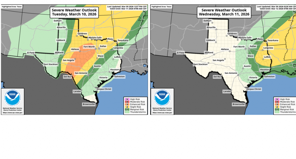
Some of the thunderstorms may be strong to severe—mainly across parts of West Texas and the Hill Country Tuesday evening and Tuesday night. The potential for severe storms appears lower for the Austin/Central Texas and coastal areas Tuesday night due to weaker atmospheric instability across these regions.
The Storm Prediction Center has placed the western Hill Country and Edwards Plateau regions under an Enhanced Risk, or 3 out of 5 risk, for severe thunderstorms Tuesday through Tuesday night. All severe weather hazards will be possible, including wind gusts to 75 mph, hail of 2 inches diameter or larger, and isolated tornadoes. Further east, SPC forecasters show a 1 out of 5 risk for severe thunderstorms across the Austin/I-35 corridor Tuesday night.
A few showers and isolated thunderstorms may continue across the region through Wednesday morning, with the chance for rain ending Wednesday afternoon. In fact, the sky is forecast to become partly cloudy Wednesday afternoon. High temperatures Wednesday are predicted to reach near 78-80 degrees.
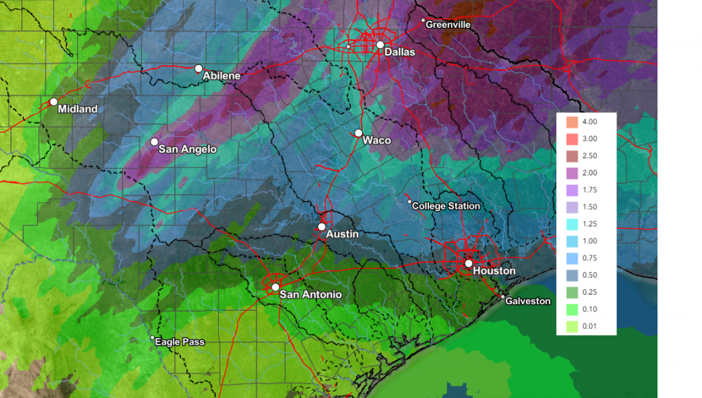
Rain amounts from the showers and storms Tuesday through Wednesday are forecast to generally average between 0.5 and 1 inch, with some isolated higher totals. Somewhat lower totals are predicted for areas south of Interstate 10.
NWS Rainfall Forecast Valid through 7 pm Thursday:
Cooler temperatures will arrive Wednesday night in the wake of a Canadian cold front. Gusty northerly winds with speeds of 10-20 mph are forecast to develop Wednesday night and continue through Thursday afternoon. Sunny and dry weather is expected Thursday and Friday as a ridge of high pressure spreads over Texas from the west.
- Lows Thursday morning will include the low and mid-40s across the Hill Country, the upper 40s across Central Texas, and the low 50s across the coastal plains
- High temperatures Thursday are forecast to be near 68-70 degrees
- Lows Friday morning will generally be in the mid and upper 40s
- Highs Friday look to be near 78-80 degrees
The outlook for the upcoming weekend and next week calls for sunny and dry weather across the region as the previously mentioned ridge of high pressure strengthens across the western U.S. and northern Mexico. It will be warm this weekend, with high temperatures in the mid-80s Saturday, and in the upper 80s to 90 degrees on Sunday.
Forecasts call for another brief cool down early next week in the wake of a cold front arriving late Sunday night. High temperatures next Monday and Tuesday are forecast to be in the 60s. Lows Tuesday and Wednesday mornings are forecast to be in the mid and upper 40s. Warmer temperatures are forecast for the middle and latter parts of next week, with highs returning to the mid and upper 80s. Lows should be in the 60s.
Forecasts show the weather pattern remaining dry for our region into the week of March 23rd, as the jet stream and storm track remain well to the north of our region.
Warmest Winter and a Record Dry Winter for Texas
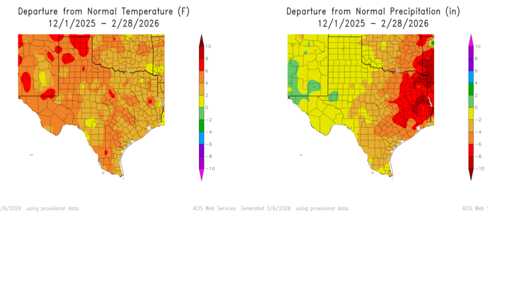
Recently released data from NCEI shows the winter of 2025-2026 was the warmest and one of the driest on record for Texas. Winter rainfall averaged 2.07 inches and ranks as the 5th lowest on record. Winter’s temperature averaged 53.1 degrees, and ranks the warmest on record, dating back to 1895.
Have a good week!
Bob
Social Media