A Chance for Rain and Storms Will Continue into the Upcoming Weekend
April 13, 2026
An unsettled weather pattern brought periods of rain and thunderstorms to the region over the weekend. An area of storms spread across the northern Hill Country Friday night, producing a large swath of 1–2-inch totals over the area between Rock Springs, Junction, Mason, Llano, and Burnet. The storms on Sunday produced two areas of heavy rain. The first area was southeast of Austin, close to Interstate 10. A widespread area of 2–3-inch totals stretched from just east of Gonzales, to Columbus, to just north of Houston. A core of 7–8-inch totals occurred across northern Lavaca and southern Fayette Counties. The second area of heavy rain occurred across southern San Saba, northern Llano, and northwestern Burnet Counties. Totals within this second area generally ranged between 3 and 6.5 inches. 3-day totals across the rest of the region generally remained below 0.75 inches.
NWS Estimate of Rain Falling Between 7 am Friday and 7 am Monday:
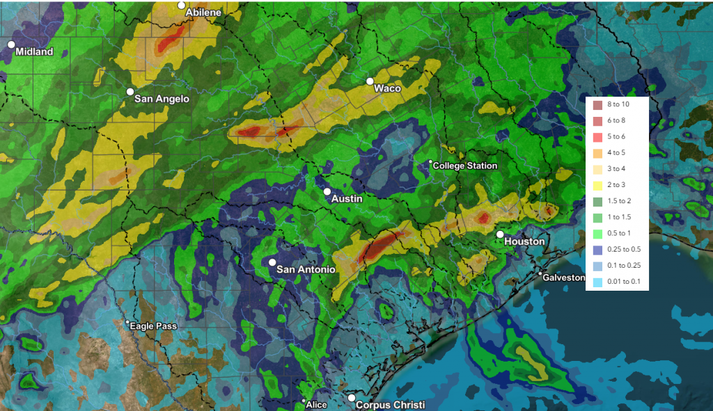
Data courtesy NOAA’s West Gulf River Forecast Center
Monday’s analysis showed the trough of low pressure responsible for this weekend’s wet and unsettled weather has exited northeast of our region. As a result, atmospheric moisture levels have begun to drop from the unusually high levels observed earlier. This means the threat for additional heavy rain has diminished—at least for the time being. Without a source for strong atmospheric lift, only an isolated shower or two is forecast across the region through Monday night. The probability for rain will be less than 20 percent. Expect a partly to mostly cloudy sky Monday afternoon with the temperature warming to the mid-80s.
Tuesday is expected to be another generally dry day across the region. Morning clouds should give way to a partly cloudy sky in the afternoon. Expect high temperatures in the low and mid-80s. Forecasters will be monitoring western Texas where scattered thunderstorms are forecast to develop in the late afternoon along the dry line. High-resolution forecasts call some of the thunderstorms to track east through the western and northern Hill Country Tuesday evening. It’s possible a couple of the storms could reach as far east as Mason and San Saba Counties, before dissipating late Tuesday night. Some of these storms could be strong to severe—producing large hail and damaging winds. Spotty totals of 0.5 to 1 inch are forecast. No rain is predicted for the eastern Hill Country, the Austin/Central Texas area, or the middle Texas coast.
Wednesday and Wednesday night will see a chance for showers and thunderstorms develop across the Hill Country and Central Texas regions as vigorous trough of low pressure moves from the southern Rockies to the Plains states. Moisture levels are expected to rise across the region in advance of the trough, and this may lead to the development of a few showers and isolated thunderstorms Wednesday afternoon. However, a better chance for showers and thunderstorms is forecast to occur late Wednesday afternoon into Wednesday night as an area of rain and thunderstorms develops along the West Texas dry line and spreads to the east. Forecasts call for a broken line of thunderstorms to push east across the Hill Country late Wednesday afternoon into Wednesday evening, then spread east through Central Texas late Wednesday evening. There’s a slight chance a few storms could reach the middle Texas coast after midnight Wednesday night. The probability for rain will be near 40-50 percent. High temperatures Wednesday are predicted to be in the mid-80s.
Some of the storms across the Hill Country could be strong to possibly severe. The Storm Prediction has placed the Hill Country region under a 1 out 5 risk for severe thunderstorms Wednesday and Wednesday night. The primary severe weather threats will be large hail and damaging winds.
Rain amounts Wednesday through Thursday morning across the Hill Country and Central Texas regions are forecast to generally average between 0.25 and 0.5 inches, with isolated totals to around 1 inch possible.
Thursday and Friday are shaping up to be partly cloudy and dry as the upper trough moves off to the northeast, and a more stable atmosphere sets up across the region. High temperatures both days are forecast to be in the mid and upper 80s.
A chance for rain and scattered thunderstorms will return to the forecast late Friday night into Saturday when a moderate cold front sinks south through the region. Forecasts call for the front to spread across the Hill Country Saturday morning, reaching Central Texas early to mid-afternoon, and the coastal region in the late afternoon and early evening. Showers and scattered thunderstorms are forecast ahead of and along the cold front, but another chance for showers and isolated thunderstorms is predicted to develop behind the front Saturday night into Sunday as a weak overrunning pattern takes shape. The probability for rain will be 40-50 percent on Saturday, and near 30-40 percent Saturday night through Sunday.
Temperatures will trend a bit cooler behind the cold front late Saturday through next Monday.
- High temperatures Sunday and Monday are forecast to be in the mid-70s
- Lows Sunday and Monday mornings will range from around 50 degrees across the Hill Country, to the upper 50s near the coast
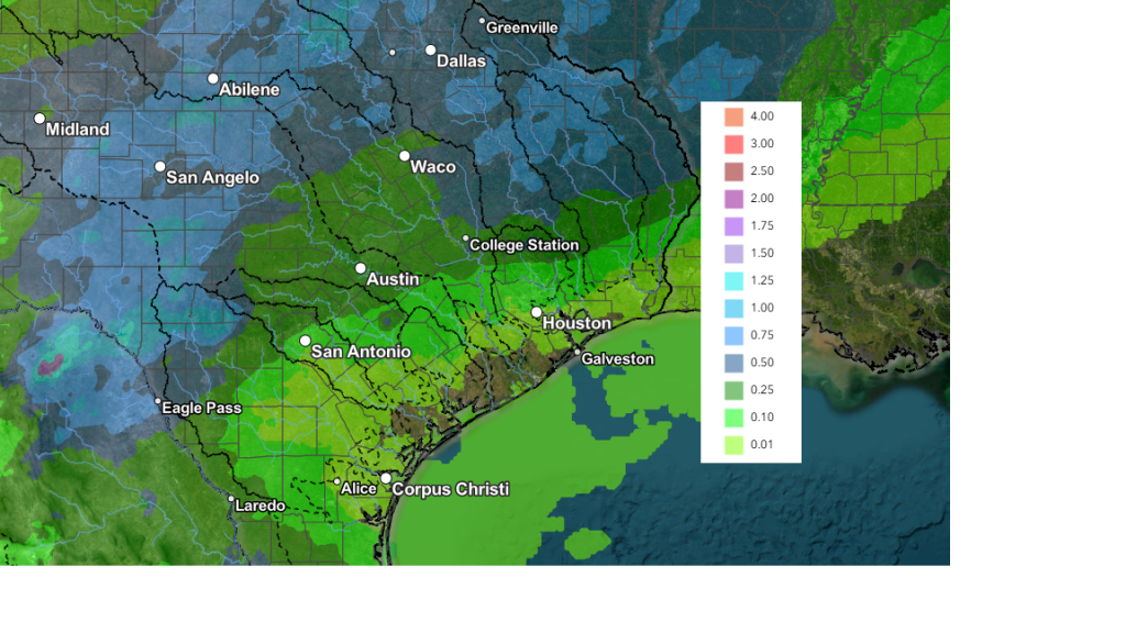
NOAA’s Weather Prediction Center 7-day total rainfall forecast through next Monday calls for general totals of 0.5 to 1 inch across the Hill Country and less than a half inch for most other locations:
The outlook for next week calls for a slight chance for rain Monday and Tuesday, with a slightly better chance for rain the second half of next week. Forecasts show our region will remain under a southwesterly wind flow out of the Pacific throughout the week. High temperatures are predicted to generally be in the mid-80s.
Comet PanSTARRS
Our weather and cloudy skies likely won’t be cooperating, but I wanted to make everyone aware a comet is currently visible in the early morning sky and will remain visible through next Sunday morning.
Over the weekend, Comet PanSTARRS (C/2025 R3) almost doubled in brightness as it approached the sun for a 0.5 AU close encounter on April 19-20. Observers are now reporting magnitudes near +4.5. This is not quite visible to the unaided eye, but it is definitely a target for binoculars and small telescopes.
If you want to view or photograph Comet PanSTARRS, set your alarm for no later than ~3 am. The comet rises in the eastern sky 60 to 90 minutes before the sun. Look low in the east, inside the Great Square of Pegasus.
Bob
Social Media