

A Chance for Rain Forecast through the Middle of Next Week. Expect a Short Break in the Heat
July 10, 2026
It’s been a hot week as the summer pattern began to take shape in earnest across the area. In fact, many locations this week recorded their hottest temperatures so far this summer. However, a break in the summer pattern will be developing this weekend and the first half of next week as the heat dome shifts well up to the north, allowing moisture and atmospheric disturbances to spread over the area. Slightly lower temperatures this weekend will include a slight chance for scattered showers and thunderstorms. Chances for rain are expected to be the highest Monday and Tuesday.
Friday’s analysis showed a weak, non-tropical area of low pressure situated over northern Mexico and Far South Texas. The low is forecast to slowly push to the west through the weekend. A counterclockwise flow around the low is expected to pull an enhanced area of tropical moisture inland Friday afternoon, continuing through the weekend. The enhanced moisture is expected to cause the development of scattered, mainly afternoon rain showers and thunderstorms.
- Friday afternoon, the most favorable area for scattered showers and isolated thunderstorms is forecast to be across the coastal plains, where the probability for rain will be near 40 percent. Further inland and up to the Austin/Interstate 35 corridor, there will be a 20-30 percent for scattered rain showers and thunderstorms. The showers and not expected to make it as far inland as the Hill Country. For areas that happen to see rain, totals should average around a quarter inch, with isolated totals to near 1 inch possible.
- For Saturday and Sunday, the best chance for scattered showers will likely remain across the coastal plains region, where the probability for rain will be near 50-60 percent. Daily rain amounts will average between 0.25 and 0.5 inches, with isolated totals to near 1 inch. Across the Hill Country and Central Texas regions, the chance for rain and isolated storms will be near 20-30 percent. Spotty totals to around a quarter inch are predicted along with some isolated heavier totals.
We should see the temperature trend a little less hot through the weekend due more clouds and increased moisture.
- High temperatures Friday through Sunday are forecast to be in the mid-90s across Central Texas and in the low 90s across the Hill Country and the coastal regions
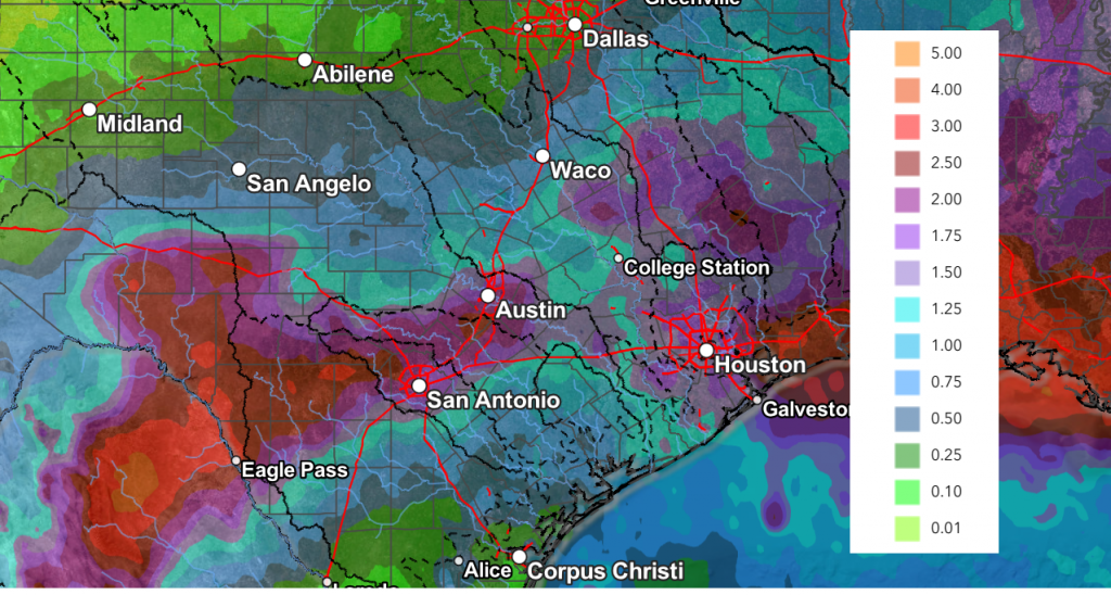
An unsettled and potentially wet weather pattern appears to be setting up next Monday through Wednesday as the center of the heat dome pulls north to the Dakotas, allowing a trough of low pressure to spread into Texas from the Mississippi Valley. A very moist atmosphere and increasing instability is expected to cause a widespread coverage of disorganized showers and thunderstorms across the region Monday and Tuesday, with a somewhat lower chance for rain and storms on Wednesday. The probability for rain across the region Monday and Tuesday will be near 60-70 percent, decreasing to 30 on Wednesday and just 20 percent on Thursday.
Forecasts are showing the potential for the development of moderate and possibly even heavy rain across the region Monday through Tuesday. Totals of 1-3 inches are predicted. However, these generous totals may not quite pan out. The reason for the concern is a dense area of Saharan dust is forecast to arrive onto the Texas coast Monday. Depending on how far inland this plume gets, it could act to suppress the development of showers and storms. As of now, I’m still leaning toward the wetter solution.
NWS Rainfall Forecast Valid through 7 pm Friday, 7/17:
- High temperatures Monday through Wednesday are forecast to generally be near 90-92 degrees.
Dry and hot weather will make a quick return late next week as the area of low pressure exits to the west and the center of the heat dome begins to shift south from the Dakotas to the southern Rockies. High temperatures are forecast to return to the mid and upper 90s.
Next weekend, continuing through the week of July 20th, dry and very hot weather is forecast as our region comes under the influence of a strong heat dome centered over New Mexico. Daily high temperatures are predicted to hold near 98-100 degrees through the period.
Tropical Weather Outlook
Weather conditions remain very quiet across the tropical Atlantic, the Caribbean Sea and the Gulf. Atmospheric conditions are expected to remain unfavorable for the development of tropical cyclones through the next week.
Colorado State Forecasters Further Reduce the Number of Storms Expected this Year
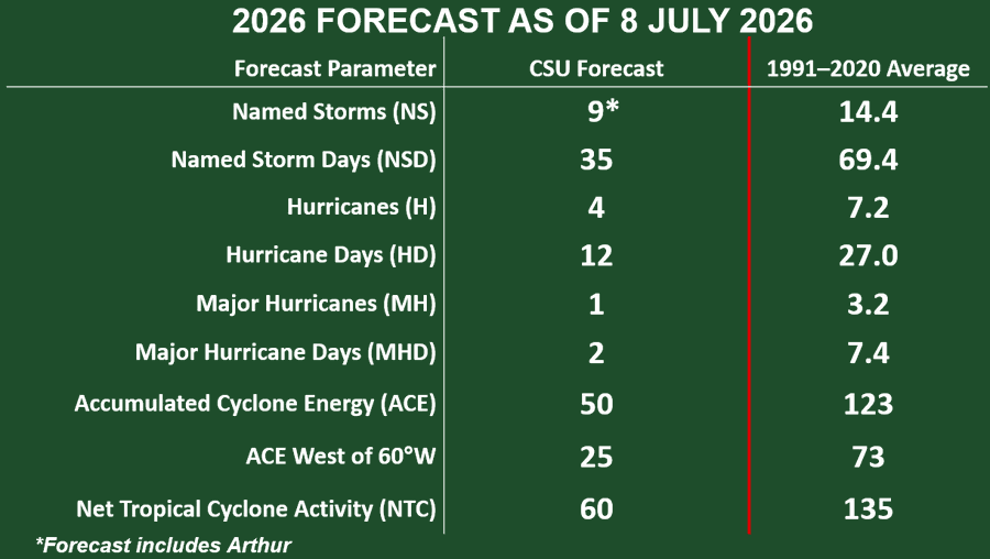
Phil Klotzbach and his forecast team at Colorado State University further reduced the number of tropical storms and hurricanes predicted for 2026. In an update released Wednesday, the team is now calling for a well below normal season. With a strong potential for a strong El Nino to be in place during the peak of this year’s hurricane season, high levels of wind shear are forecast to be in place which should limit the development of storms. The team is also predicting a well-below normal probability for major hurricanes to make landfall along the continental U.S. coastline.
The CSU team is now calling for 9 named storms (normal is 14), 4 hurricanes (normal is 7), and 2 major hurricanes (normal is 3).
I am going to be taking some time out of the office over the next couple of weeks. My next report will be around July 25th.
Have a great weekend!
Bob
Social Media