A Couple of Chances for Rain this Week. Temperatures to Stay Very Mild
FEB. 9, 2026
Spring-like temperatures will continue this week, with no hints of additional cold weather returning anytime soon. This week’s weather will feature a couple of opportunities for rain, but rain amounts are not expected to be very heavy.
Monday’s weather maps showed a broad ridge of high-pressure covering Texas and the south-central U.S. The ridge will cause a sunny sky Monday afternoon, along with near record-breaking heat. High temperatures are predicted to be in the low and mid-80s. A few spots across Central Texas may even reach the upper 80s.
A second feature on Monday’s maps was an area of low pressure located just west of Baja, California. This system is forecast to lift northeast, moving across Mexico Tuesday, then across Texas Tuesday night into Wednesday morning. Middle and high-level clouds will increase across the region Monday night ahead of the low. Moisture and low clouds will be drawn north across the region after midnight Monday night. This will lead to areas of fog across the entire region late Monday night through mid-morning Tuesday. The sky looks to stay mostly cloudy Tuesday afternoon.
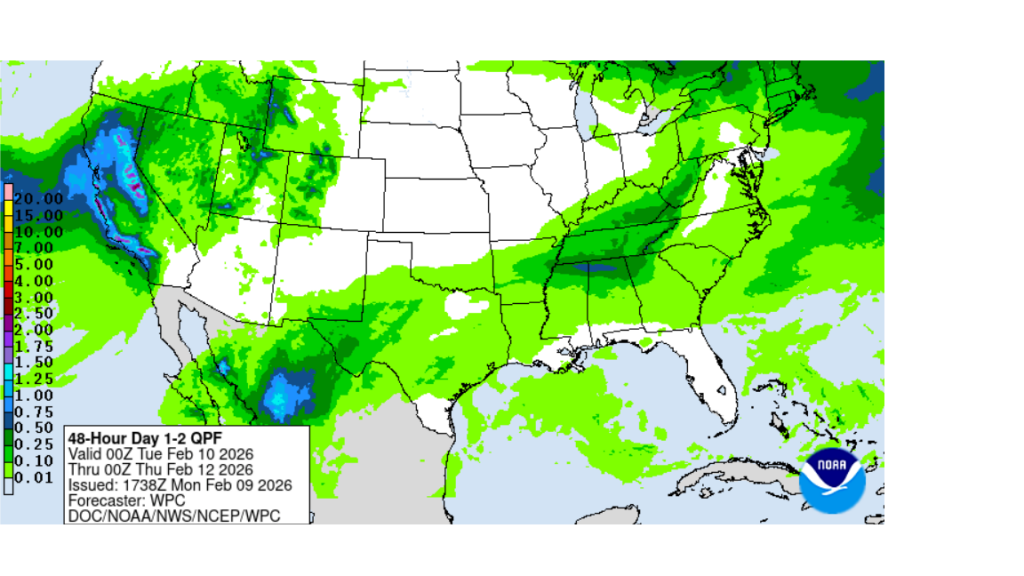
Light rain showers are forecast to develop across West Texas late Tuesday afternoon, then spread across the Hill Country and Central Texas regions Tuesday night as the low pressure system gets closer to the area. A few light showers may continue into Wednesday morning, with the precipitation gradually ending from west to east. With only limited moisture and atmospheric lift in place, rain amounts will be low, with most total only averaging around a tenth of an inch or less. Tuesday’s temperature is predicted to reach the mid-70s.
NWS Rainfall Forecast Valid through 6 pm Wednesday:
A Pacific cold front associated with the low pressure system is forecast to sweep southeast across the area early Wednesday, bringing very light change in the temperature. Sunny conditions will develop Wednesday afternoon and continue through Thursday.
- High temperatures Wednesday will be in the mid-70s, warming to the low 80s Thursday and Friday
- Lows Thursday and Friday mornings will range from the mid-50s across the Hill Country, to the low 60s near the coast
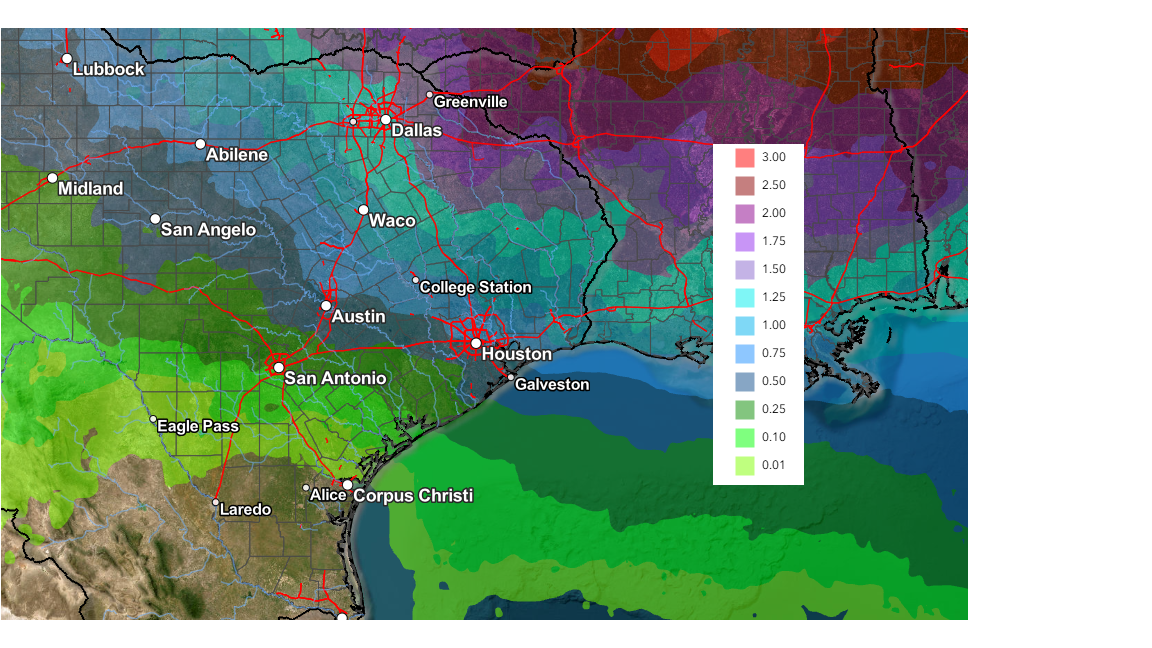
Forecasts call for a second trough of low pressure to move south along the West Coast late week, with the trough pushing east across the Desert Southwest and southern Plains states this weekend. This next trough looks stronger than the system early in the week and is expected to have better moisture ahead of it. This should result in the development of more widespread rainfall and somewhat heavier rain, compared to the early week system. The chance for rain is forecast to begin Friday evening and continue through Saturday evening. The probability for rain will be 50 percent.
Rain amounts from this system will be heaviest across North and Northeast Texas, with lower totals expected across Central Texas. Rain amounts through 6 pm Saturday are forecast to generally average between a quarter and a half inch, with a few isolated heavier totals possible.
NWS Rainfall Forecast Valid through 6 pm Saturday:
No significant change in the temperature is expected over the weekend. High temperatures are predicted to generally be in the low 70s. Lows Sunday and Monday mornings will range from the mid-40s across the Hill Country, the low 50s near the coast.
The outlook for next week calls for continued mild temperatures with little to no rain. Forecasts call for our region to be situated between a large trough of low pressure across the western U.S. and a large ridge of high pressure over the Southeast. Daily high temperatures are forecast to near 78-80 degrees, with lows in the upper 50s to low 60s.
There are no signs of arctic air heading toward Texas over the next two-week period.
Have a good week!
Bob
Social Media