A Daily Chance for Rain and Thunderstorms Forecast through Late Next Week
April 10, 2026
An unsettled, active weather pattern has taken hold across Texas. This change has come about as the persistent ridge of high pressure over Texas has recently shifted to the east, allowing a southwesterly flow in the middle and upper atmosphere to develop from eastern Pacific into Texas. At the same time, moisture levels have increased significantly thanks to a moderate wind flow off the Gulf. This setup is expected to remain in place through late next week, keeping a daily chance for rain and thunderstorms in the forecast.
For Friday afternoon and Friday night, scattered rain showers and isolated thunderstorms are forecast across the region due to abundant moisture and a modest amount of instability. No severe weather is anticipated. The probability for rain at any given location will be near 40-50 percent. For locations that do see rain, totals should average around a quarter inch, with isolated totals to near 1 inch possible. Expect high temperatures in the low 80s. The rain activity will diminish Friday evening, followed by cloudy and dry weather Friday night through Saturday morning.
Saturday’s weather is looking to be similar to Friday’s weather with a cloudy sky through the morning hours, followed by a partly to mostly cloudy sky in the afternoon. There will be a 40-50 percent chance for showers and scattered thunderstorms Saturday afternoon into Saturday evening due to persistent instability across the area. Rain amounts through Saturday evening will again average around a quarter inch, with isolated totals to near 1 inch. Saturday’s temperature is forecast to generally warm to the low 80s.
A large area of strong to possibly severe thunderstorms is forecast to develop across the Concho Valley and areas to the south Saturday evening as a wave of low pressure begins to lift northeast out of Mexico. This area of rain and storms is predicted to push to the east and spread across the Edwards Plateau and Hill Country regions late Saturday night into early Sunday morning. Should the area of storms hold together, some of the storms may spread east to the Austin/Interstate 35 corridor Sunday morning. Atmospheric conditions appear to be somewhat favorable for a few of these storms to be strong to severe. The primary severe threats will be large hail and damaging winds. The Storm Prediction Center has placed the Hill Country under a 2 out of 5 risk for Sunday. The remainder of the region has been placed under a 1 out of 5 risk.
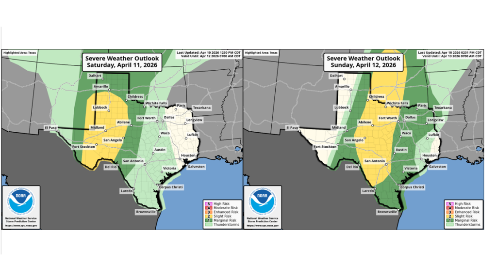
Sunday’s early-morning storms are forecast to decrease in intensity by late Sunday morning. However, a passing wave of low pressure over the area Sunday is expected to cause an increased chance for rain showers and scattered thunderstorms across the region Sunday afternoon into Sunday evening. A few of these storms may be strong to severe. The probability for rain will be near 60-70 percent. The chance for rain looks to decrease Sunday evening and Sunday night.
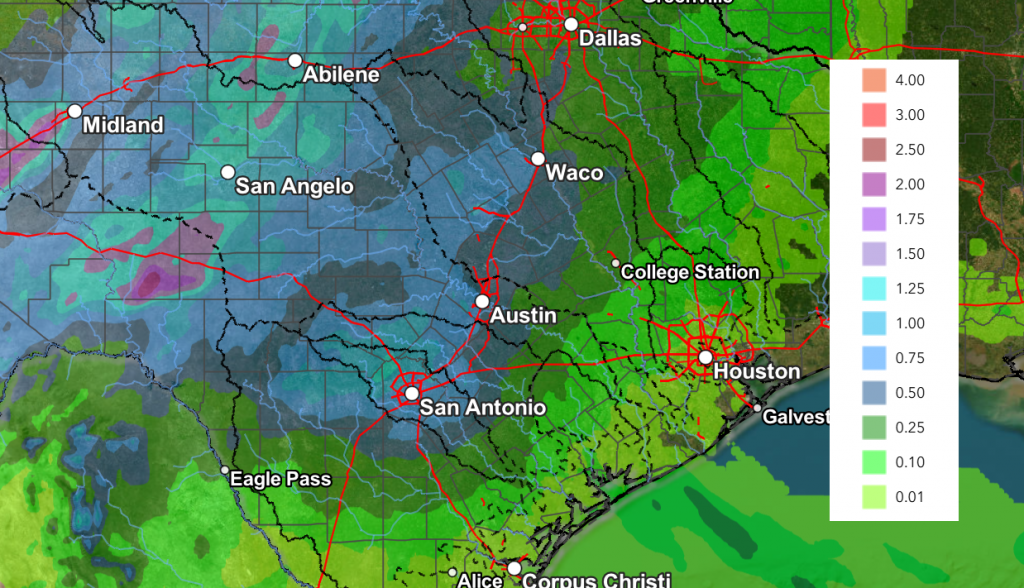
Rain amounts through Saturday afternoon are forecast to average between 0.5 and 1 inch across the Hill Country and between 0.25 and 0. 5 inches at most other locations. Isolated totals of 2-3 inches will be possible across the area.
NWS Rainfall Forecast Valid through 7 pm Sunday:
Looking ahead to next week, forecasts call for another wave of low pressure to spread across Texas Monday, causing the development of more showers and scattered thunderstorms across the region, with the most favorable area for rain occurring across the Hill Country and the I-35 corridor. The probability for rain Monday looks to be near 40-50 percent and rain amounts should average between 0.25 to 0.5 inches.
Tuesday through Friday, forecasts call for the active weather pattern to continue with at least a slight chance for rain and thunderstorms each day. The probability for rain each day will be near 20-30 percent. High temperatures next week are forecast to be mostly in the mid-80s.
Interestingly, this unsettled pattern looks to also continue into the following week.
La Niña is Done. The Pacific has returned to ENSO Neutral
NOAA’s Climate Prediction Center announced Thursday La Niña has ended and ENSO-neutral conditions have returned to the tropical Pacific. The persistent tongue of cooler than-normal waters has diminished as warmer water has spread in from the west. NOAA calls for these waters to continue warming over the next few months, with high probabilities for the development of El Nino by summer.
Have a great weekend!
Bob
Social Media