A Potential for Heavy Rain into Friday and Again Early Next Week
NOV. 20, 2025
Pockets of very heavy rain developed Wednesday night into Thursday morning across the western half of the Hill Country and the Edwards Plateau as thunderstorms trained over the area. As of 3 pm, LCRA’s Hydromet showed 5 to7-inches of rain have occurred over the area from just east of Sonora, to Menard, to Brady. A second area of heavy rain with totals of 2-3 inches has occurred across western Gillespie County.
Gauged totals of rain falling between 6 pm Wednesday and 3 pm Thursday from LCRA’s Hydromet:
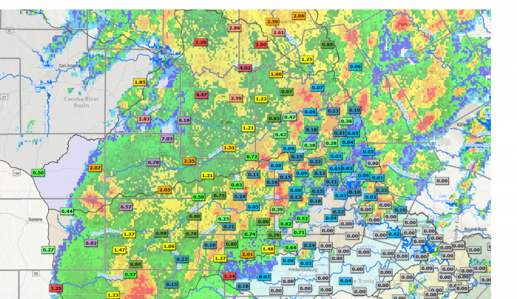
The heavy rain falling Wednesday night into Thursday morning has been the result of a slow-moving, vigorous trough tracking northeast out northern Mexico. Forecasts call for the trough to slowly lift northeast across the Panhandle region Thursday afternoon and Thursday night. High resolution forecasts call the area of rain and thunderstorms across the western Hill County to move very slowly to the east Thursday afternoon, with the rain finally reaching the eastern Hill Country in the late afternoon and evening. The area of rain and storms is forecast be weakening when it reaches the Austin/Interstate 35 corridor early Thursday evening. The activity is then predicted to push northeast of Central Texas late Thursday evening. Due to the slow movement of the rain across the Hill Country, additional significant totals of rain will be possible.
A new area of rain showers and thunderstorms is forecast to develop between San Angelo and Abilene late Thursday evening along a Pacific cold front pushing east out of West Texas. The area of rain and storms is forecast spread to the east and should reach the Austin/Interstate 35 corridor sometime around daybreak on Friday. The area of rain is forecast to shift further to the east while weakening Friday morning. The Pacific cold front is predicted to move across Central Texas and stall somewhere close to Interstate 10 late Friday into Saturday.
Forecasts indicate additional totals of 1-4 inches will be possible across the Hill Country through Friday morning. For the Austin/Interstate 35 corridor and most of Central Texas, totals through Friday morning are forecast to be a little lower—generally between 0.5 and 2 inches
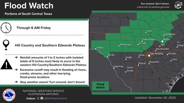
A Flood Watch remains posted for the Hill Country and the Austin/Interstate 35 corridor through 6 am Friday.
For the coastal plains region, the best chance for rain is expected to occur Friday night through Saturday with the cold front stalled along the I-10 corridor. Periods of isolated thunderstorms can be expected, with totals generally in the range of 0.25 to 0.5 inches.
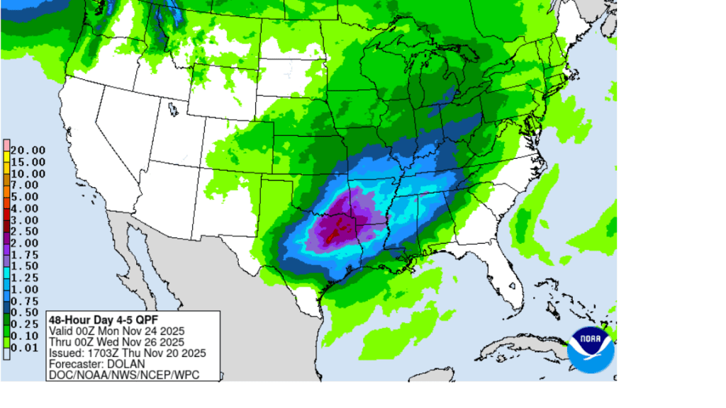
Attention turns to Sunday and early next week when a second trough of low pressure is forecast to track east-northeast out of the Desert Southwest. This system is expected to cause the development of widespread rain showers and thunderstorms across our region beginning Sunday afternoon, continuing through Monday night. Totals from this system are forecast to generally average between 1 and 2 inches across the northern Hill Country, and between 1 and 1.5 inches at most other locations.
NWS Rainfall Forecast for the Period 6 pm Sunday through 6 pm Tuesday:
Generally dry weather is forecast Tuesday through Thanksgiving Day. Temperatures are forecast to trend cooler Thanksgiving Day and late next week. Expect highs in the 60s, with lows in the 40s.
Bob
Social Media