

A Rare Cold Front Saturday. Otherwise, Few Changes to the Hot and Dry Pattern
July 31, 2026
It’s been a hot week across Texas, with the temperature climbing close to or reaching 100 degrees each day. Unfortunately, no significant change in the temperature is be expected over the next couple of weeks as our region will remain under the influence of a stagnant summertime heat dome.
Friday’s weather is offering few changes in the hot and dry pattern. High temperature are forecast to be in the upper 90s at most locations. A few spots along the Interstate 35 corridor, including Austin, could reach 100 degrees. Expect a southerly breeze at 5-10 mph.
Saturday looks to see a few changes in the weather as the center of the heat dome briefly shifts from eastern New Mexico to western Arizona. This will allow a trough of low pressure to dive south the Plains and enable a weak cold front to sink south into Texas. The front is forecast to spread south, reaching the Interstate 20 corridor across North Texas Saturday morning, The front is predicted to move across the Hill Country late Saturday morning into the first half of Saturday afternoon then push south through Central Texas late Saturday afternoon into Saturday evening. The cold front is expected to stall somewhere close to Interstate 10 late Saturday evening.
An area of elevated moisture accompanying the cold front may help to cause the development of a few spotty rain showers and isolated thunderstorms along and just behind the cold front. The probability for rain across the Hill Country will be near 20 percent, while across Central Texas and the coastal regions, the chance for rain will be near 30 percent. Rain totals, if any, are forecast to average less than a quarter inch. The chance for rain will diminish behind the front as drier and more stable air flows into the area.
NWS Rainfall Forecast Valid through 7 am Sunday:
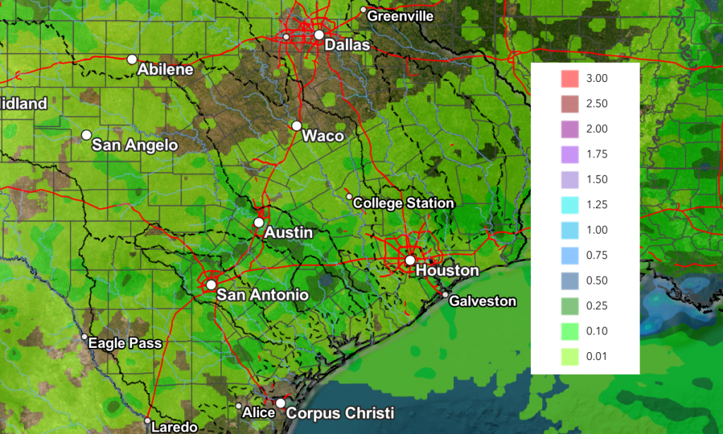
Despite the approaching cold front, Saturday’s weather is expected to remain mostly sunny and hot with high temperatures generally in the upper 90s.
Sunday is shaping up to be sunny and continued hot. However, drier air behind the cold front is expected to make for noticeably less humid conditions across the Hill Country and Central Texas regions. High temperatures will include the mid-90s across the northern Hill Country, and upper 90s at most other locations.
Monday will see more sunny and hot weather along with increasing relative humidity levels as Saturday’s cold front lifts back to the north. Next week, the center of heat dome is forecast to spread back to the southern Rockies and southern Plains. For our region, this means continued sunny, hot, and dry.. Daily high temperatures are forecast to generally be near 98-100 degrees.
Looking out further to the week of August 10th, few changes are expected as the center of the heat dome remains parked across the southern Plains. Daily high temperatures look to stay around 98-100 degrees. No rain in on the horizon.
Tropical Weather Outlook
Weather conditions remain very quiet across the tropical Atlantic, the Caribbean Sea and the Gulf. Atmospheric conditions look unfavorable for tropical cyclone development over the next seven days.
I hope everyone has a good weekend. Continue to practice heat safety and be sure to stay cool and hydrated!
Bob
Social Media