A Significant Cold Outbreak and Wintery Precipitation Expected this Weekend
JAN. 21, 2026
- A Winter Storm Watch has been Posted for the Hill Country and Central Texas regions from late Friday Night through Sunday Morning and for the coastal region through Sunday afternoon
- An Extreme Cold Watch has been posted for Saturday and Sunday
- There will be Increasing chances for freezing rain and ice accumulation Saturday into Sunday morning
- Dangerously cold temperatures and wind chills will be in place this weekend into early next week
- A Significant Winter Storm will impact much of Texas this weekend. There will be widespread travel impacts
- Maximum winterization preparation will need to be completed by Friday afternoon to help mitigate infrastructure damage
Forecasts continue to indicate an impactful winter storm with dangerously cold temperatures will affect our region this weekend. Wednesday’s forecast solutions are now giving forecasters a better idea on the magnitude of the cold air and the extent of the wintery precipitation.
Temperatures
The leading edge of the arctic air is forecast to push into north and northwest Texas Friday morning. The front should move across the northern Hill Country late morning, reaching the Austin area sometime early Friday afternoon, and the coastal region Friday evening. Breezy conditions with wind gusts to around 20/25 mph are forecast Friday afternoon through Saturday. Temperatures are predicted to steadily fall behind the front, with temperatures falling from the 60s, to the 40s, 30s, and 20s Friday night. The freezing line expected to move south and be close to the Interstate 10 corridor by sunrise Saturday morning. The freezing line is forecast to push south through the coastal region Saturday afternoon. Additional arctic air will spread south Saturday into Saturday night, driving temperatures even colder. Temperatures look to stay below freezing across the Hill Country and most of Central Texas between Saturday and Monday afternoon, making this a long-duration freeze.
Here’s a rough idea on expected temperatures:
- Lows Saturday morning will include the low and mid-20s across the Hill Country, the upper 20s across Central Texas, and in upper 34s across the coastal plains
- Lows Sunday morning are forecast to be in the low and middle teens across the Hill Country, the upper teens to low 20s degrees across Central Texas, and the middle 20s towards the coast
- Lows Monday and Tuesday mornings are predicted to be in the low teens across the Hill Country, the mid-teens to 20 degrees across Central Texas, and in the low 20s across the coastal plains
- High temperatures Saturday are forecast to be in the mid-20s across the Hill Country, the low 30s across Central Texas, and in the 40s across the coastal region
- High temperatures Sunday are forecast to be in the low and mid-20s across the Hill Country, the upper 20s across Central Texas, and in the low to mid-30s across the coastal plains.
- High temperatures Monday will range from the mid-30s across the Hill Country, to around 40 degrees across Central Texas and the coastal region
Slowly warming temperatures are forecast next Tuesday through Friday.
Precipitation
An overrunning weather pattern behind the arctic front will have the potential to produce a crippling ice storm across the Hill Country, Central Texas, and coastal regions Saturday into Sunday. Waves of low pressure moving up from Mexico will cause periods of light to moderate rain Friday afternoon and Friday evening. The precipitation is forecast to transition to freezing rain mixed in with some sleet across the Hill Country Friday night through Saturday evening. Across Central Texas, the transition to freezing rain mixed in with a little sleet is forecast to take shape Saturday morning and continue through Saturday evening. For the coastal region, rain showers are forecast Saturday, with a transition to freezing rain with some sleet expected Saturday night into early Sunday morning. This is looking to mainly be a freezing rain and ice event. The chance for any snow will be quite low.
All the precipitation is forecast to come to an end Sunday morning, with the sky slowly clearing Sunday afternoon.
Ice Accumulation
Wednesday’s forecast data is hitting hard on significant impacts from the freezing rain. Although it’s a little early to get into specifics, forecasts are indicating the potential for ice accumulation Saturday through Sunday to be in the range of 0.10 to 0.25 inches across the Hill Country and much of Central Texas. For the coastal plains, ice accumulations are forecast to be near or just under a tenth of an inch. Very low totals of sleet are expected. These types of accumulations point to increasing concerns for downed tree limbs and power outages.
The following National Weather Service graphic shows the area that has the best chance of seeing at least minor impacts from the ice:
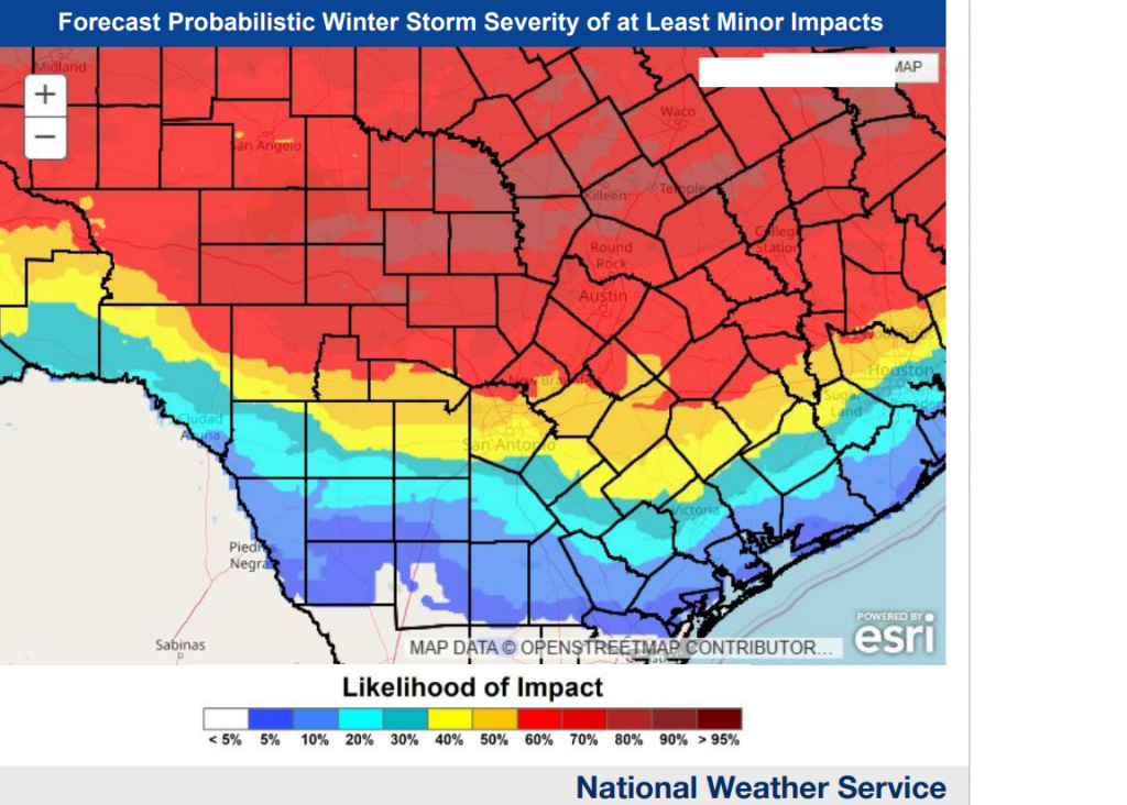
Keep in mind, that any precipitation that falls will likely remain frozen into Monday. As readings go above freezing Monday, some melting will take place. But the ice may not go away entirely until Tuesday. Note that ice amounts of only .01 inch can result in dangerous driving conditions, especially on elevated bridges/overpasses/ramps/and connectors.
Travel impacts are looking increasingly likely Saturday through Monday.
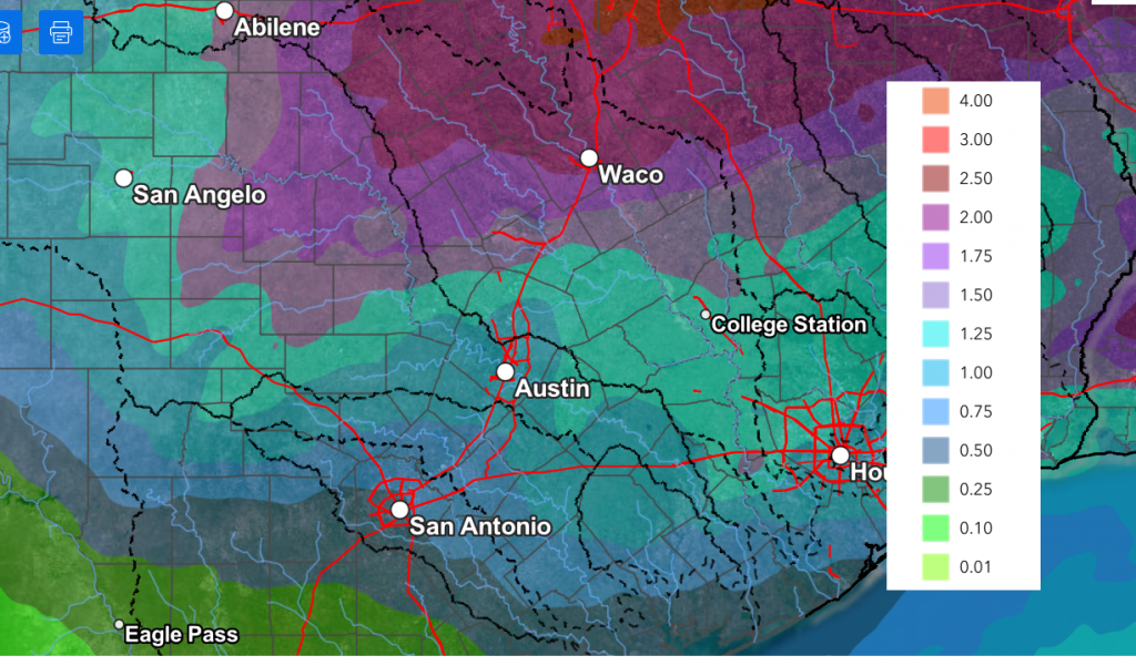
Significant precipitation is expected this weekend. The National Weather Service forecast calls for liquid totals of 1-1.25 inches across much of the area.
NWS rainfall forecast valid through 6 pm Sunday:
Preparations
- Proper winterization of any exposed pipes/plumbing will be needed to prevent infrastructure damage. Sprinkler systems must be shut off and properly drained. Exterior facing wall pipes will be a risk of freezing at the forecasted temperatures
- Pets and livestock will require proper shelter to protect from the cold temperatures and wind chills
- Tropical plants/vegetation will require maximum freeze protection. Unprotected tropical vegetation will be killed and even protect vegetation will likely suffer heavy damage
- Persons should limit outdoor exposure during the cold. Utilize heating sources properly to reduce the risk of fire and carbon monoxide poisoning
Bob
Social Media