A Wet and Unsettled Weather Pattern Setting Up for Next Week
May 15, 2026
Partly cloudy, warm, and humid weather is expected this weekend. No rain is forecast as the atmosphere will likely be much too stable. The weather pattern will begin to change early next week to one that will favor cloudy conditions with periods of rain and scattered thunderstorms across the region. This wet and unsettled pattern is forecast to remain in place throughout the week and even into next weekend. There will be a potential for heavy rain developing sometime during the second half of next week.
Friday Afternoon through Sunday
Expect a pattern of nighttime and morning clouds, followed by partly cloudy sky conditions in the afternoon. A weak ridge of high pressure in place over the area is forecast to slowly shift to the northeast. Gusty southerly breezes are predicted through Sunday due to a strengthening pressure gradient across the state. Forecasts call for wind speeds of 10-15 mph, with occasional gusts to 25/30 mph.
The southerly breezes will pull warm and increasingly moist air inland from the Gulf. Rising humidity levels this weekend combined warm afternoon temperatures will create uncomfortable and dangerous heat index readings. Forecasts call for peak index readings to approach 108 degrees Sunday into early next week. The National Weather Service may issue Heat Advisory for much of the area due to the expected high readings.
The higher humidity levels will translate to warmer nighttime temperatures. Lows Saturday and Sunday mornings are forecast to generally be in the mid and upper 70s. Daily high temperatures are predicted to be close to 90 degrees.
Next Week
Forecasts call for a series of low pressure troughs to push inland along the West Coast next week, with the troughs eventually tracking east across the southern Rockies and into the Plains state.
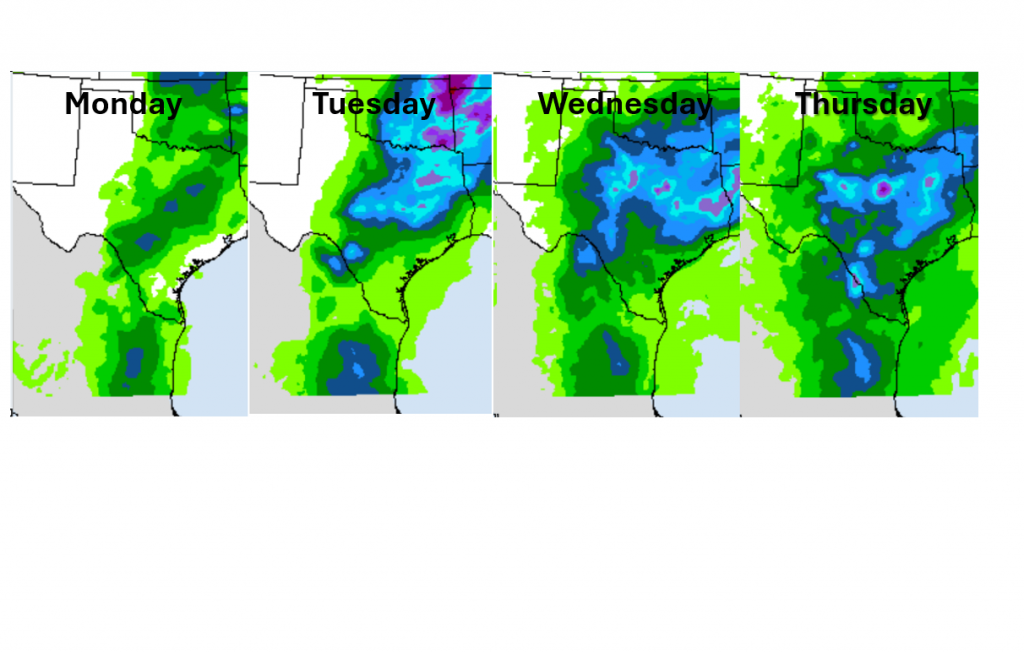
The first trough is expected to help push the dry line east out of West Texas Monday. Scattered afternoon thunderstorms building along the dry line are predicted to spread east across the Hill Country and into parts of Central Texas late Monday afternoon into Monday evening. Severe storms are not anticipated.
Tuesday through Friday, periods of rain showers and thunderstorms are forecast as small waves of low pressure spread over Texas ahead of the main trough. A more widespread coverage of rain and thunderstorms is expected, compared to Monday as the waves of low pressure take on a more southerly trajectory across Texas.
In each potential round of storms, modest flow aloft and good instability will support a few strong to severe storms capable of producing large hail and damaging winds. However, widespread severe weather seems unlikely at this time. That being said, with it being May and quite a bit of uncertainty this far in advance, it will be good to plan on occasional interruptions in outdoor events while keeping a severe weather plan in place.
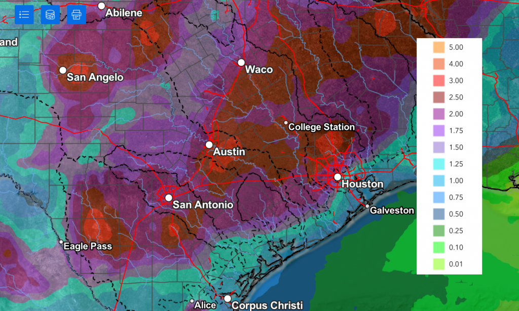
The probability for rain each day next week is forecast to be near 50-60 percent. There are some indications for heavier rain developing the second half of next week. Daily rainfall totals are predicted to be in the range of 0.5 to 1 inch for most locations.
Weather Prediction Center’s Daily Rainfall Forecast through Thursday:
Weather Prediction Center’s Cumulative Rainfall through Next Friday at 7 pm.
High temperatures next week are predicted to be near 90 degrees Monday and in the mid to upper 80s Tuesday through Friday.
Next Weekend
Extended-range forecasts indicate the wet and unsettled pattern will continue next weekend into the following week as more waves of low pressure spread across Texas from the Desert Southwest. Conditions look favorable for additional rounds of rain showers and thunderstorms into the week of May 25th. No significant change in the temperature is forecast through the period.
Update on the Development of El Nino
On Thursday, NOAA’s Climate Prediction Center issued its monthly update on the state of the Pacific. CPC forecasters indicated ENSO-neutral conditions are still in place, but El Nino will likely develop soon (June or July) as additional warm water spreads eastward from the western Pacific Ocean. While confidence in the occurrence of El Niño has increased since last month, there is still substantial uncertainty in the forecasted peak strength of El Niño, with no strength categorization exceeding a 37% chance at this time.
An El Nino Watch remains posted.
Have a great weekend!
Bob
Social Media