Another Wave of Rain Expected Monday. Sunny and Cooler for Thanksgiving
NOV. 21, 2025
The threat for additional heavy rain across Texas has come to an end as the storm system responsible for Friday’s heavy downpours has shifted north into Oklahoma and Kansas. Drier and more stable air moving in behind a Pacific cold front will cause the sky to become partly cloudy to mostly sunny across the Hill Country Friday afternoon. There will be a 30 percent chance for showers and isolated thunderstorms across Central Texas Friday afternoon as the cold front slowly pushes to the southeast. Dry weather will follow Friday night. Meanwhile, the best chance for showers and scattered thunderstorms (near 50 percent ) Friday afternoon through Saturday morning is expected to be across the coastal plains region where the cold front is predicted to sag to the south and stall. Rain amounts through midday Saturday are forecast to be in the range of 0.25 to 0.5 inches.
- High temperatures Friday are predicted to be in the mid and upper 70s, with mid-80s expected across the coastal plains
- Lows Saturday morning will range from the upper 40s and low 50s across the Hill Country, to the upper 50s across Central Texas, to the upper 60s near the coast
A mostly sunny to partly cloudy sky is forecast across the Hill Country and Central Texas on Saturday. Clouds will clear with the sky becoming mostly sunny across the coastal region Saturday afternoon.
- High temperatures Saturday are forecast to be in the low and mid-70s, with low 80s across the coastal plains
- Lows Sunday morning will generally be in the mid-50s to low 60s
Another period of rain showers and scattered thunderstorms is forecast to take shape across the region late Sunday into Monday as a second Pacific trough of low pressure moves into Texas from the Desert Southwest. As the low approaches West Texas on Sunday, Gulf moisture is forecast to surge north over the area, bringing a return to an overcast sky. Forecasts call for showers and thunderstorms to develop across West Texas Sunday afternoon ahead of and along a Pacific cold front that will be moving to the east. Some of this activity may spread over parts of the Hill Country Sunday afternoon. Showers and thunderstorms are forecast to spread west to east across the Hill Country, Central Texas and coastal regions Sunday night into Monday. The probability for rain will be near 70-80 percent and with abundant moisture in place, some of the rain may be moderate to heavy. The rain is expected to taper off from west to east Monday morning through Monday afternoon.
For areas that saw significant rain on Thursday, this additional heavy rain may lead to some flash flooding.
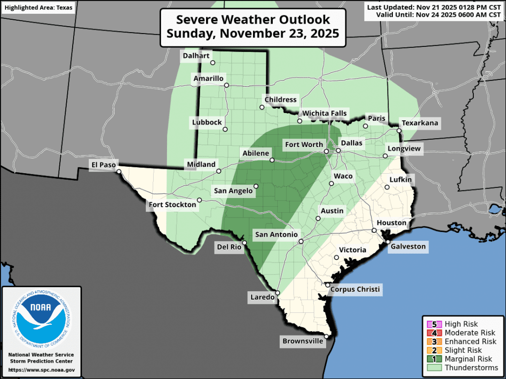
In addition, strong to marginally severe storms will also be possible from this storm system, with the main concerns being large hail and damaging winds. The Storm Prediction Center’s Severe Weather Outlook for Sunday and Sunday night shows a 1 out of 5 risk for severe thunderstorms for most of the Hill Country.
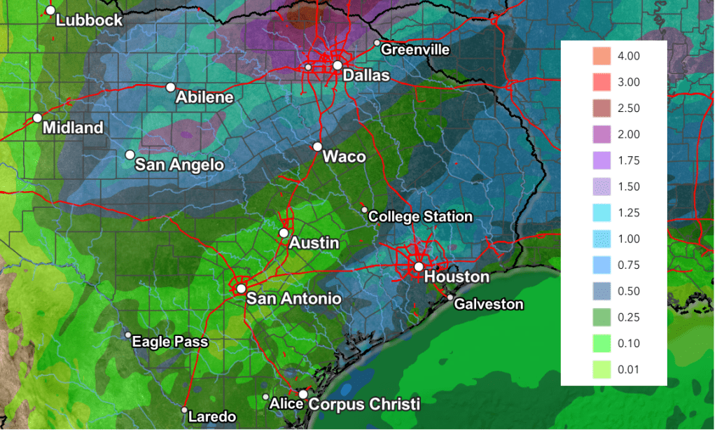
Rainfall from this next system is predicted to heaviest across North Texas and Oklahoma. Friday’s forecast data now points to somewhat lower totals across Central and South Texas. Totals through Monday evening are forecast to average around a half inch across the Hill Country, and around 0.25 inches or less elsewhere
NWS Rainfall Forecast for the Period 6 pm Sunday through 6 pm Monday:
A dry weather pattern is forecast to develop late Monday and continue through late next week. A mostly sunny sky can be expected Tuesday through Friday. A fairly stout cold front is forecast to push south across the area late Tuesday that will bring much cooler weather for Wednesday, Thanksgiving Day, and Friday.
- High temperatures Monday and Tuesday are forecast to be in the mid and upper 70s.
- Lows Tuesday and Wednesday mornings will be in the upper 40s to low 50s
- High temperatures Wednesday through Friday will range from the upper 50s to low 60s across the Hill Country, to the low and mid-60s towards the coast
- Low temperatures Thursday and Friday mornings will include the mid-30s across the Hill Country, the upper 30s to low 40s across Central Texas, and the low 40s across the coastal plains.
Mostly sunny and slightly warmer weather is forecast for the weekend following Thanksgiving.
Tropical Weather Outlook
Weather conditions are quiet and tropical cyclone development is not expected over the next seven days.
Hurricane Melissa’s 252-mph Wind Gust Sets New Record
The National Center for Atmospheric Research has confirmed that a 252-mph wind gust was measured in Hurricane Melissa, setting a new record for the highest wind speed reported by a dropsonde — a weather instrument released by Hurricane Hunter aircraft. The dropsonde is a small weather station attached to a parachute that measures various weather elements as it descends to the Earth’s surface, transmitting the data back to the aircraft.
The 252-mph wind gust measured by the dropsonde in Hurricane Melissa was recorded at 827 feet (250 meters) above the ocean on Oct. 28, the same day Melissa made landfall in Jamaica as a Category 5 storm. The previous record for a dropsonde measurement was 248 mph, taken during Typhoon Megi over the Western Pacific in 2010.
Because the reading wasn’t taken at the Earth’s surface, it does not count officially in the World Meteorological Organization’s world wind records. The official world wind record remains 253 mph, clocked by an automated weather station during Tropical Cyclone Olivia on April 10, 1996, at Barrow Island, Australia. (Courtesy Accuweather)
Have a great weekend!
Bob
Social Media