Arthur Develops. Heat Advisory Posted for Thursday
June 17, 2026
Data from radar and satellite plus information from a U.S. Air Force Hurricane Hunter Aircraft indicate there is enough convective organization to designate the system near the Texas coast as Tropical Storm Arthur—the first tropical cyclone of the 2026 Atlantic hurricane season.
Over the past couple of hours, coastal stations from Freeport to Sabine Pass have been reporting winds gusting to 35-50 mph
AS of 10 am CDT, tropical storm Arthur was centered just off the middle Texas coast, just to the east of Matagorda Bay. Arthur was moving toward the northeast near 9 mph. An increase in forward speed is expected today. On the forecast track, the tropical storm should move northeastward along the Texas coast today and then move inland over southwestern Louisiana by tonight. Surface observations and data from the Air Force Reserve Hurricane Hunters indicate maximum sustained winds have increased to near 40 mph with higher gusts. Little change in strength is expected before the center moves over land. Weakening is anticipated once the low moves inland, and Arthur could dissipate by tonight or early Thursday.
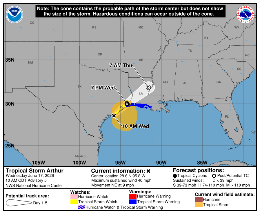
Based on the forecast track of Arthur moving toward Louisiana, the storm is not expected to impact weather conditions across the Hill Country or Central Texas regions Wednesday. Expect a mostly sunny sky with highs in the low 90s. For the middle Texas coast, there will be a 50 percent chance for scattered rain showers and isolated thunderstorms through late afternoon. Rain amounts should average less than a half inch. Expect highs in the upper 80s.
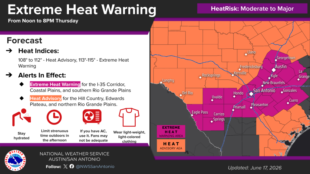
Thursday is shaping up to be a sunny and very hot day across the region as a large area of sinking air spreads in from the northwest.
- High temperatures are forecast to be near 98-100 degrees across the western Hill Country, with mid and upper 90s across the eastern Hill Country. Across Central Texas, High temperatures are predicted to be in the mid and upper 90s. The coastal region should see highs in the low and mid-90s.
A humid air mass will be in place Thursday. The combination of the very hot temperatures and high relative humidity levels is expected to bring a moderate to major heat risk to the region.
- The National Weather Service is forecasting peak afternoon heat index readings of 108-112 degrees across the Hill Country. A Heat Advisory has been posted for this area.
- The National Weather Service is forecasting peak heat index readings of 113-115 degrees across the Austin and Central Texas area. An Extreme Heat Warning has been posted for this area.
Friday is expected to be another sunny and hot day. However, temperatures and moisture levels are forecast to be a little lower and this should result in somewhat lower heat index readings. Peak heat index readings of 108-110 degrees are forecast for the Austin and Central Texas area.
Forecasts point to showers and thunderstorms developing across parts of West and Northwest Texas Thursday evening and Thursday night as a cold front sags southeast out of the Panhandle. Rain and thunderstorms are predicted to spread into the Hill Country out of West Texas late Thursday night into Friday morning. Additional showers and thunderstorms are forecast to develop across the region Friday through Saturday as the front sags a little further to the south. With a very moist air mass in place, some locally heavy rain will be possible. A slight chance for rain looks to continue into Sunday.
Bob
Social Media