

August Heat Wave Continues with Little Relief in Sight
AUG. 21, 2026
Unfortunately, the August heatwave is far from winding down. In fact, some of the hottest temperatures so far this August are predicted to occur this weekend, followed by more triple-digit heat next week. Rain-free weather looks to continue for at least another week, although parts of the region could see a few spotty showers Friday and Saturday afternoons.
Friday’s weather maps showed a strong and intense ridge of high pressure, or heat dome, stretching from the northern Rockies, southeast through Texas and into the western Gulf. The heat dome was centered Friday morning near the Four Corners. Forecasts call for the center of the heat dome to shift east to the Texas Panhandle this weekend, then slowly shift back west through New Mexico the middle and latter part of next week. With the heat dome’s proximity getting closer to our region over this weekend and early next week, high temperatures are forecast to climb 2-3 degrees from what we’ve been seeing this week.
Forecasted high temperatures Saturday through Monday:
- 100-105 degrees across the Hill Country
- 101-106 degrees across the Austin/Central Texas area
- 100-102 degrees across the middle Texas coast
These very hot temperatures will combine with high relative humidity levels to produce peak heat index readings of 107-113 degrees! Because of these extreme temperatures, the National Weather Service has posted a Heat Advisory for the Austin/Central Texas region, the northern and eastern Hill Country, and all Southeast Texas through the weekend.
I do want to point out there will be a very low chance for parts of Central Texas to see a few spotty rain showers or isolated thunderstorms spread into the area from the northeast late Friday afternoon into Friday evening. This is due to a weak cold front stalling over northeast Texas and northwest Louisiana. Moisture pooling along the front may spark the development of a few thunderstorms over East Texas Friday afternoon, with steering winds carrying any potential storms to the southwest. There will be a very low chance (less than a 20 percent probability) a couple of these storms could make it as far west as Interstate 35 Friday evening. Rain amounts, if any, should total less than a quarter inch.
There will be another very slight chance for a few spotty showers and isolated thunderstorms across the northern half of the Hill Country and all Central Texas late Saturday afternoon into Saturday evening as the weak cold front is predicted to sag just a little further to the south. Once again, the probability for rain will be at or less than 20 percent. Rain amounts, if any, should total less than a quarter inch. Note; any developing thunderstorm will have the potential to produce strong and gusty downburst winds.
The chance for any additional rain will diminish Sunday through late next week as the weak cold front weakens and moves back to the north.
Next week’s weather is shaping up to be sunny and very hot as our region will remain under the influence of the strong, nearly stationary heat dome. High temperatures next Tuesday through Friday are forecast to be near 100-104 degrees across the Hill Country and Central Texas regions, and near 99-101 degrees across the middle Texas coast.
Forecasts looking out into the week of August 31st call for few changes. Sunny, hot, and dry weather looks to continue as the heat dome remains over Texas. There are some indications the heat dome will be trending weaker at that time. Daily high temperatures are forecast to come down just a bit and be around 98-100 degrees at most locations.
Tropical Weather Outlook
Weather conditions remain very quiet across the Gulf and the Caribbean Sea and tropical cyclone development here is not expected over the next seven days.
- National Hurricane Center forecasters are monitoring a weak area of low pressure located over the central subtropical Atlantic, a few hundred miles east-southeast of Bermuda that is producing an area of disorganized showers and thunderstorms. Development of this system, if any, is expected to be slow to occur while it drifts west-southwestward through Sunday. The system is forecast to turn northward early next week. NHC is giving this system a 20 percent for tropical development over the next seven days.
- Out over the northeastern Atlantic, a non-tropical area of low pressure has developed several hundred miles north-northeast of the Azores. This system could acquire some subtropical or tropical characteristics on Saturday or early Sunday while it moves east southeastward at 10 to 15 mph toward Portugal and northwestern Spain. The opportunity for tropical or subtropical development should end by Sunday night when the system moves into unfavorable environmental conditions. NHC is giving this system a 20 percent chance for tropical development over the next seven days.
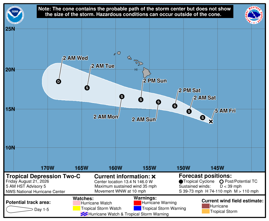
In the central tropical Pacific, forecasters are monitoring the progress of a tropical depression that may bring rainfall and gusty winds to the Hawaiian Islands over the next few days.
As of 10 am CDT Friday, the center of Tropical Depression Two-C was located about 745 miles southeast of Hilo, Hawaii. The depression was moving toward the west-northwest near 10 mph. This general motion is expected to persist over the next several days, with the center of the system passing south of the Big Island of Hawaii this weekend, then the smaller main Hawaiian Islands by early next week. Maximum sustained winds were near 35 mph with higher gusts. Gradual strengthening is forecast over the next couple of days, and the depression is forecast to become a tropical storm Friday evening.
Updated Outlook for September and this Fall
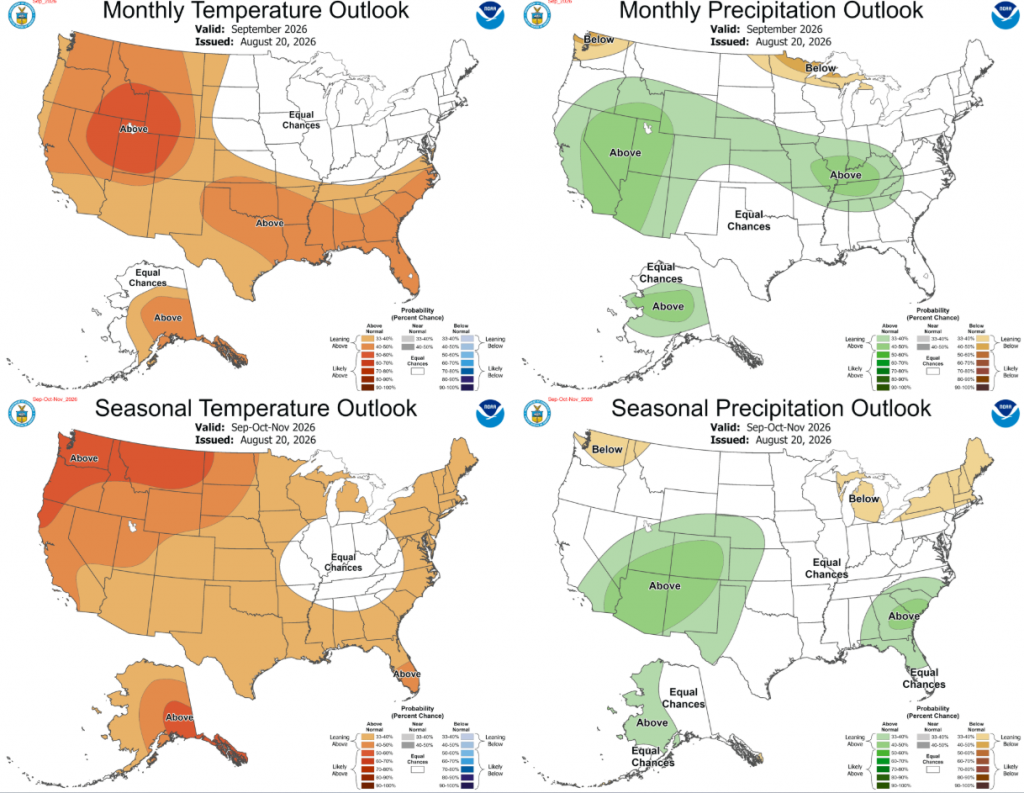
On Thursday, The National Weather Service’s Climate Prediction Center issued their monthly updated outlook for September and this fall. Forecasters noted El Niño was beginning to influence the weather pattern across North America and was helping to pump up the heat dome across the southwestern and south-central U.S. These forecasters felt the heat dome would continue to be a strong influence on Texas weather into September and possibly October. The outlook leans toward above normal temperatures, with no clear trend yet for above-, below-, or near-normal rainfall. On other charts, CPC forecasters are showing a clear trend for above normal rainfall across Texas by November.
Have a great weekend! Stay cool, hydrated, and out of the heat as much as possible.
Bob
Social Media