Chances for Rain and Thunderstorms Increase Beginning Late Wednesday
March 30, 2026
Confidence has increased in the forecast for rain later this week and for the upcoming weekend. Not only has the chance for rain gone up but forecasted rain amounts have also increased. It’s not out of the question that much of our area could receive between 1 and 2 inches of rain over the next seven days. After another warm week, cooler temperatures will arrive this weekend and look to stick around for a good part of next week.
Warm and rain-free weather is predicted across the region Monday through Wednesday afternoon. Humidity levels will be on the increase thanks to a moderate wind flow off the Gulf. Expect southerly winds with speeds of 10-15 mph and gusts to 25 mph through Wednesday.
- High temperatures Monday through Wednesday are forecast to be in the mid and upper 80s
- Lows Tuesday and Wednesday mornings will generally be in the mid and upper 60s
The weather pattern is expected to become more active beginning late Wednesday, continuing through the upcoming weekend as two separate troughs of low pressure track east out of the western U.S. The first trough is predicted to track from the southern Rockies to the central Plains states late Wednesday into Thursday. Forecasts call for an area of showers and thunderstorms to develop along the West Texas dry line late Wednesday in advance of the approaching trough. High resolution forecasts call for the line of thunderstorms to push east, spreading across the Hill Country Wednesday evening into Wednesday night, with the showers and thunderstorms reaching the Austin/Central Texas area after midnight Wednesday night, and the coastal region before daybreak Thursday. The probability for rain will be near 50 percent.
As of now, severe thunderstorms are not anticipated due to just modest instability.
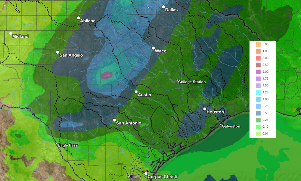
Rain amounts through Thursday afternoon are forecast to average between 0.5 and 1 inch across the Hill Country, and between 0.25 and 0.5 inches for most other locations.
NWS Rainfall Forecast Valid through 7 pm Thursday:
The chance for rain and thunderstorms is expected to diminish from west to east Thursday afternoon, followed by dry weather Thursday night through Friday afternoon. High temperatures Thursday and Friday are forecast to be in the mid-80s.
The second and stronger trough of low pressure is forecast to track northeast from the southern Rockies late Friday and will help to push a Canadian cold front south through Texas on Saturday. Forecasts call for the cold front spread across the Hill Country Saturday morning into early Saturday afternoon, reaching the Austin/Central Texas area Saturday afternoon and the coastal region Saturday evening. While some scattered rain showers and thunderstorms are forecast across the region Friday night into Saturday morning ahead of the front, it appears the most widespread and heavier precipitation will fall behind the cold front in an overrunning setup Saturday afternoon through Sunday morning. Some occasional light showers may continue Sunday afternoon into Sunday night.
As of now, the threat for severe storms appears low since the heavier rains will be falling behind the cold front. However, we will need to monitor the situation over the next few days.
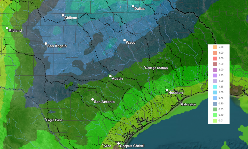
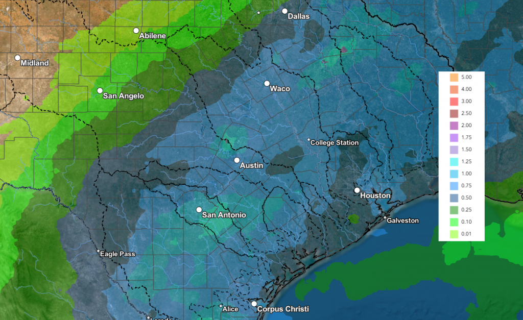
Rain amounts between late Friday and Sunday evening are forecast to generally average between 1 and 2 inches across the region. Some pockets of higher totals will be possible.
NWS Rainfall Forecast for the Period 7 pm Thursday through 7 pm Saturday:
NWS Rainfall Forecast for the Period 7 pm Saturday through 7 pm Monday:
Cooler air will follow the cold front beginning Saturday afternoon and Saturday night.
- Lows Sunday morning will include the mid and upper 40s across the Hill Country, the low 50s across Central Texas and the mid-50s towards the coast
- High temperatures Easter Sunday will generally be in the mid-60s
- Lows Monday morning are forecast to be in the mid-40s across the Hill Country, the upper 40s across Central Texas, and the low 50s across the coastal plains
- High temperatures Monday are forecast to be in the low 70s
The outlook for next week calls for mostly sunny and dry weather. Daily high temperatures are predicted to be mostly in the 70s, with lows in the 50s.
A slight chance for rain is forecast next weekend (April 11-12).
Have a great week!
Bob
Social Media