Chances for Rain Returning Late Week into the Upcoming Weekend
April 6, 2026
Saturday’s cold front brought another round of some much-needed rain to the region. Weekend rain amounts generally averaged between 0.5 and 1 inch, although several Hill Country locations saw totals of less than a quarter inch. Combining both rain recent events since last Wednesday, several spots across the Hill Country and Central Texas have measured between 2 and 3 inches of rain so far for April.
Sunshine has returned to the region as drier air has finally spread in behind the weekend cold front. Satellite images show considerable middle and high-level clouds associated with a weak trough of low pressure located over Arizona and northern Mexico. These clouds are moving to the east and will likely spread over most of Texas Tuesday and Tuesday night, causing a partly to mostly cloudy sky. The atmosphere will be too dry for any rain. A mostly sunny to partly cloudy sky is forecast Wednesday.
Cool temperatures are forecast Monday afternoon and Monday night, but warmer readings are expected Tuesday into Wednesday as east and southeasterly breezes return.
- Lows Tuesday morning are predicted to be in the low and mid-40s across the Hill Country, and in the upper 40s across the rest of the region
- High temperatures Tuesday will be in the low and mid-70s
- Lows Wednesday morning will generally be in the low 50s, with mid and upper 50s expected towards the coast
- High temperatures Wednesday look to be near 78-80 degrees
There will be a low (20-30%) chance for a few rain showers and isolated thunderstorms for areas along and east of Interstate 35 on Thursday as moisture increases off the Gulf. The chance for rain showers and scattered thunderstorms for this same area will increase to 30-40% Friday as the atmosphere is forecast to become quite moist and somewhat unstable. Meanwhile, the chance for rain across the Hill Country on Friday is predicted to only be near 20 percent.
Rain amounts Thursday through Friday are forecast to average between 0.25 and 0.5 inches for the coastal plains region, and between a tenth and quarter inch for areas along and east of Interstate 35.
An unsettled weather pattern is predicted to continue this weekend and into Monday as a large trough of low pressure pushes inland along the West Coast. While considerable moisture will remain across Central Texas and coastal regions, the most favorable area for rain and thunderstorms is expected to shift to northwest Texas and the Concho Valley region as thunderstorms develop along the West Texas dry line and track to the east. Both Saturday and Sunday will bring a 50 percent chance for mainly afternoon and evening rain showers and thunderstorms to the Hill Country and the Interstate 35 corridor regions, and a 30-40 percent chance for rain for the remainder of Central Texas and the middle Texas coast. Some of the storms across West Texas could be strong to severe. Showers and a few thunderstorms look to continue into next Monday before the western trough lifts north into the southern Rockies.
Rain amounts Saturday through Monday are forecast to generally average between 0.5 and 1 inch across the Hill Country, and between 0.25 and 0.5 inches at most other locations. I will point out there are some forecast model solutions calling for higher totals Sunday into Monday. Stay tuned for additional updates.
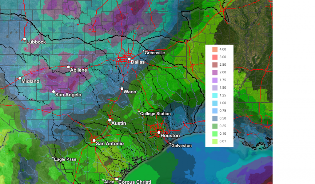
Total rain amounts through next Monday evening are forecast to be between 0.5 and 1 inch across the Hill Country, and between 0.25 and 0.5 inches for most of the rest of the region.
NWS Rainfall Forecast Valid through Next Monday at 7 pm:
Temperatures late week and through the weekend will include highs in the low 80s, with lows in the 60s.
The outlook for the remainder of next week calls for dry weather next Tuesday through Thursday, followed by another chance for rain late week into the following weekend. No significant temperature change is forecast. Expect high temperatures in the low and mid-80s, with lows in the 60s.
Have a great week!
Bob
Social Media