Chilly Nighttime Temperatures Expected throughout the Week. A Chance for Rain Late Wednesday through Thursday.
DEC. 1, 2025
The month of December is starting off cold and a little damp. Sunday’s strong cold caused a big change in the temperature and it looks to bring our region the first taste of sustained winter-like nighttime readings. Winter is not settling in just yet as milder readings are forecast to return for this weekend and next week.
Drizzle and light rain developed across Central Texas and the middle Texas coast early Monday as moist and mild Gulf air spread up and over the chilly air mass at the surface. Totals as of early Monday afternoon only measured a few hundredths across Central Texas but have been close to a half inch across Wharton and Matagorda Counties. A trough of low pressure tracking southeast across the Panhandle region is responsible for the ongoing clouds and rain. Forecasts call for the trough to exit to the east late this afternoon and evening, causing the rain to taper off. The sky is expected to clear from west to east late this evening and overnight, allowing for chilly temperatures to develop. In fact, temperatures early Tuesday morning are shaping up to be the coldest of the week. A light freeze is forecast across the Hill Country along with some of the traditional cold pockets across Central Texas, including Williamson County.
- Lows Tuesday morning will include the upper 20s to low 30s across the Hill Country, the low and mid-30s across Central Texas, and the upper 30s across the coastal plains.
Milder temperatures are forecast Tuesday into Wednesday. Expect a sunny sky on Tuesday, followed by a partly to mostly cloudy sky on Wednesday.
- High temperatures Tuesday are forecast to be in the upper 50s.
- Lows Wednesday morning are predicted to be near 40-42 degrees as light southerly breezes return
- High temperatures Wednesday are forecast to be in the mid and upper 60s
- Low temperatures Thursday morning will range from around 40 degrees across the Hill Country, to the mid-40s across Central Texas, to the low 50s across the coastal plains
A chance for rain showers and a few thunderstorms is forecast to develop Wednesday night, continuing Thursday and Thursday night as another wave of low pressure moves across the southern Plains states. Similar to the setup happening early this week, the greatest amount of returning moisture is predicted to be along and east of Interstate 35. Meanwhile, a Canadian cold font is also predicted to press south across the area Wednesday night into Thursday morning, enhancing the chance for rain. Light showers and a few scattered thunderstorms are forecast to develop from the eastern half of the Hill Country, southeast to the coast. The probability of rain will be near 50 percent. The rain should taper off from west to east Thursday night into Friday morning as the wave of low pressure exits to the northeast.
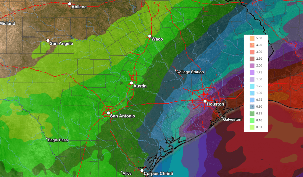
Rain amounts late week are not expected to be very heavy across the Hill Country and Central Texas regions. Totals through Friday are forecast to average around a quarter inch or less across the Hill Country, and between a quarter and a half inch across Central Texas. For the middle Texas coast, totals are predicted to be close to an inch.
NWS Rainfall Forecast Valid through 6 pm Saturday:
The outlook for the upcoming weekend calls for sunny and dry weather. High temperatures are predicted to be in the upper 60s to low 70s. Low temperatures will range from the low 40s across the Hill Country, to the upper 40s across the coastal plains.
For next week, forecasts call for mostly sunny and a bit milder weather as the jet stream takes on a more zonal, or east-to-west configuration. Daily high temperatures are predicted to be in the 60s to low 70s, with lows generally in the 50s.
Tropical Weather Recap
The 2025 Atlantic hurricane season ended Sunday. This year’s season produced 13 named storms—very close to long-term average. Of the 13 named storms, there were 5 hurricanes, including 4 major hurricanes.
No hurricanes made landfall along the U.S coast this year. This is the first year this has happened since 2015.
Updated Weather Outlook for the Month of December
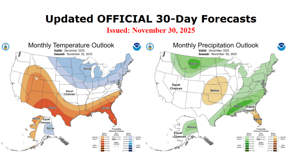
On Sunday, NOAA’s Climate Prediction Center issued an updated climate outlook for the month of December. The outlook shows strong odds the temperature will average above normal. Precipitation is forecast to average above normal for areas along and east of Interstate 35. Equal chances for above-, below-, or near-normal rainfall is forecast across the Hill Country and West Texas.
The precipitation outlook is based primarily on the latest solution from the Climate Forecast System model, which calls for near-normal rainfall across most of Texas in December.
November Climate
The month of November saw well above normal temperatures, with readings generally averaging between 6 and 9 degrees above normal! It will likely rank among the mildest Novembers on record. In Austin, the average November temperature at Camp Mabry was 67.0 degrees, which was 6 degrees above normal. November 2025 ranks as the second warmest November on record, only behind November 1927.
November rainfall was generally 1-2 inches below normal for areas from the eastern Hill Country, southeast to the middle Texas coast. Meanwhile, rainfall averaged between 1 and 3 inches above normal across the western half of the Hill Country. Austin-Camp Mabry recorded only 0.58 inches for the month, ranking as the 20th driest November on record.
Have a good week!
A Bob
Social Media