

Colder Air to Arrive Just Ahead of Thanksgiving. Limited Rainfall over the Next Week
NOV. 19, 2026
Dry and tranquil weather conditions look to continue across the region late week and through the weekend. However, changes in the weather pattern are forecast to take place next week that will bring a very small chance for rain Tuesday, No significant rain is not expected. A blast of colder air is forecast to arrive late Tuesday that will bring low temperatures down into the 30s and 40s Wednesday through Friday mornings. A light freeze may take shape across the Hill Country Thursday morning. Here are details.
…Thursday Afternoon through Friday Night…
Mostly sunny conditions are forecast both days as Texas remains under the influence of a ridge of high pressure situated over the Ohio Valley. Do note areas of dense fog are predicted to develop across much of the area late Thursday night into Friday. The fog should burn off mid to late Friday morning.
- High temperatures Thursday and Friday are forecast to be in the low and mid-70s
- Low temperatures Friday will include the upper 40s across the Hill Country, the low 50s across Central Texas, and the mid-50s across the coastal plains
- Lows Saturday morning will range from the low 50s across the Hill Country, to the upper 50s near the coast
…Saturday through Monday…
A quick-moving, trough of low pressure shifting from the Four Corners region toward Oklahoma late Saturday into early Sunday will help push a Pacific cold front into West Texas on Saturday. The front is forecast to move across Central Texas sometime late Saturday night into Sunday morning, reaching the coastal area early Sunday afternoon. A couple of spotty rain showers may accompany the cold front, but limited available moisture will keep most locations dry. Expect a partly cloudy sky Saturday, trending to sunny Sunday and Monday. Mild temperatures Saturday will cooler behind the cold front Sunday and Monday.
- High temperatures Saturday will range from the low 70s across the Hill Country, to the upper 70s towards the coast
- High temperatures Sunday are predicted to be in the mid and upper 60s across the Hill Country and Central Texas regions, and in the mid-70s across the coastal zone
- High temperatures Monday will include the upper 50s across the Hill Country, the low 60s across Central Texas, and mid-60s near the coast
- Lows Sunday morning are forecast to be in the low 50s across the Hill Country, the mid-50s across Central Texas, and the low 60s near the coast
- Lows Monday and Tuesday mornings will include the mid-40s across the Hill Country, the upper 40s across Central Texas, with low and mid-50s near the coast
…Tuesday through Wednesday…
Forecasts call for another Pacific trough of low pressure to track east across the southern Plains early next week. This trough is expected to tap into some chilly air across southern Canada and push a Canadian cold front south across Texas sometime Tuesday morning into Tuesday afternoon. Model solutions show limited moisture in place ahead of the front, meaning there will only be a very slight chance for a few rain showers along the cold front. Rain amounts, if any, should average well below a quarter inch. The chance for rain should end by Tuesday evening as drier and cooler air spills in behind the cold front. Expect a partly cloudy sky Tuesday, followed by a sunny sky, cooler temperatures, and breezy conditions on Wednesday. A light freeze will be possible across the Hill Country next Thursday morning.
- High temperatures Tuesday will range from the mid-50s across the Hill Country, to the mid-60s across the coastal plains
- High temperatures Wednesday will include the low 50s across the Hill Country, to mid-50s across Central Texas, and near 58-60 degrees towards the coast
- Low temperatures Wednesday morning will range from the low 40s across the Hill Country, to the upper 40s across the coastal plains
- Lows Thursday morning will include the low and mid-30s across the Hill Country, the mid and upper 30s across Central Texas, and near 40-42 degrees across the coastal plains
…Thanksgiving Day…
Partly cloudy and cool conditions are predicted for Thanksgiving.
- Expect high temperatures in the mid and upper 50s. Lows Friday morning will range from the mid and upper 30s across the Hill Country, to the mid-40s across the coastal plains
…Next Friday through Sunday…
Forecasts call for mostly sunny conditions, with slightly warmer temperatures. High temperatures are forecast to be in the 60s, with lows generally in the 40s.
Tropical Weather Outlook
Weather conditions are quiet across the Gulf, the Caribbean, and the tropical Atlantic.
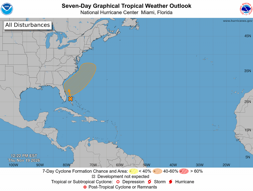
Offshore of the southeastern U.S. coast, NHC forecasters are monitoring a disorganized area of showers and thunderstorms extending over portions of the Bahamas and Florida. These showers are associated with a stalled frontal system over the area. A non-tropical low pressure system is expected to form along the front east of the Florida peninsula on Friday. This system could become a subtropical or tropical storm while it moves northward or north-northeastward near or just offshore of the southeastern U.S. coast through the weekend. Regardless of development, strong winds, dangerous surf, and coastal flooding are likely along portions of the southeast and mid-Atlantic coasts into early next week. Heavy rain and flash flooding will continue for portions of the Florida peninsula through Friday, potentially spreading toward coastal portions of the Carolinas and mid-Atlantic into this weekend.
NHC forecasters are giving this system a 60 percent chance for tropical or subtropical development over the next seven days.
Updated Weather Outlook for December
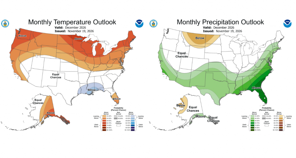
NOAA’s Climate Prediction Center issued their monthly seasonal climate outlook Thursday morning. The updated outlook for December, as well as for December through February, drawing heavily on the ongoing very strong El Niño, leans toward above normal precipitation across all of Texas. The temperature outlook shows equal chances the temperature will average above-, below-, or near-normal. The El Nino is predicted to continue influencing Texas weather into next spring.
Bob
Social Media