Colder Temperatures Arriving Friday Night. The Weather Looks to Stay Dry for Another Week
JAN. 9, 2026
There will be a low-end chance for a few scattered strong to severe thunderstorms across the eastern Hill Country and all Central Texas through mid-afternoon Friday and across the coastal region Friday afternoon through Friday evening. This chance for storms is being generated by a trough of low pressure tracking to the east across the southern Plains Friday afternoon. While the strongest forcing for the development of storms is predicted to be across East Texas and the lower Mississippi Valley, high-resolution forecasts indicate there may be just enough instability to cause a few scattered storms across Central and Southeast Texas.
The Strom Prediction Center has placed the area along and east of Interstate 35 under a Marginal, or 1 out of 5 risk, for severe thunderstorms through Friday evening. Should any storms become severe, the greatest severe weather threats will likely be large hail and damaging downburst winds. The threat for strong and severe storms should end across the eastern Hill Country and Central Texas by mid-afternoon and early evening across the coastal region.
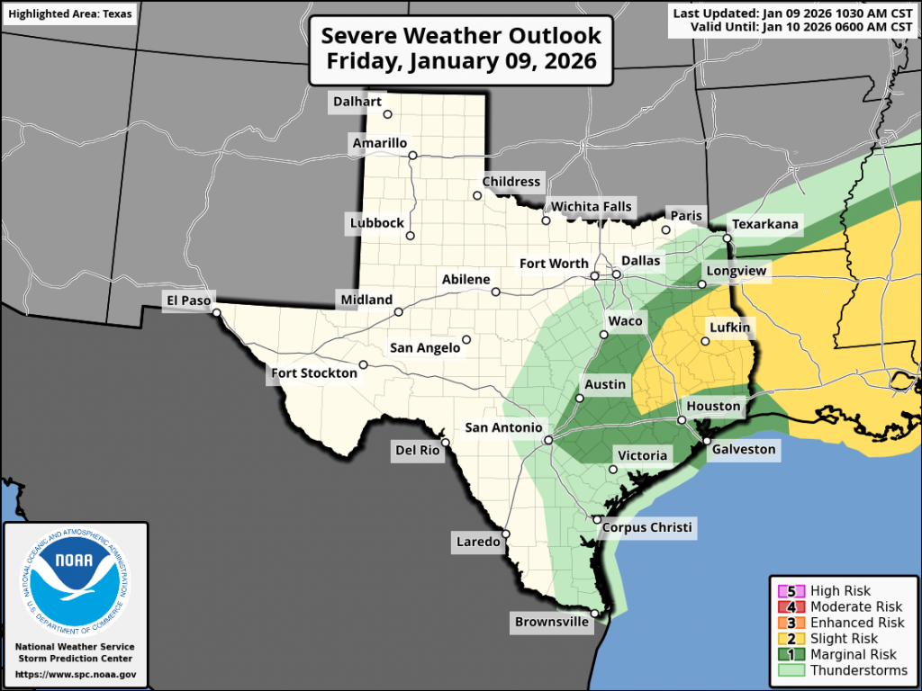
The probability for rain and storms will be near 50 percent across the eastern Hill Country and Central Texas regions and near 70 percent across the coastal plains region. Unfortunately, Friday’s rain and storm threat is not expected to generate much rain. Little to no rain is forecast across the Hill Country. Across Central Texas and the middle Texas coast, most totals should average less than a quarter inch. A couple of isolated totals to near 1 inch will be possible with some of the stronger storms.
Temperatures Friday afternoon are forecast to hold mostly in the 60s to low 70s across the Hill Country and Central Texas regions, and in the upper 70s to low 80s across the coastal plains.
Colder temperatures will arrive Friday night behind a Canadian cold front. The front is forecast to spread southeast across the region after midnight and should be well of the coast by sunrise Saturday. Strong northerly winds with speeds of 15-20 mph and gusts of 35/40 mph will develop behind the cold front Friday night, with similar wind speeds and gusts expected Saturday into Saturday evening. Lighter winds are forecast after midnight Saturday night. Expect a sunny sky Saturday through Monday.
Do note a light freeze is predicted for the Hill Country and parts of Central Texas Sunday and Monday mornings under a clear sky with light wind.
- Low temperatures Saturday morning are forecast to be in the upper 30s across the Hill Country, the low and mid-40s across Central Texas, and in the low 50s across the coastal region
- Lows Sunday and Monday mornings are predicted to be in the upper 20 to low 30s across the Hill Country, in the low and mid-30s across Central Texas, and in the upper 30s towards the coast
- High temperatures Saturday and Sunday will include the upper 50s to 60 degrees across the Hill Country and Central Texas regions, and the low 60s across the coastal region
Next Week
Dry and cool weather is predicted for all next week. An area of low pressure parked over northern Mexico is expected to push scattered middle and high-level clouds across Central and South Texas Monday and Tuesday. No rain is expected. A sunny to mostly sunny sky will follow Wednesday through Friday. Forecasts do call for another Canadian cold front to spread across the area sometime Tuesday night or early Wednesday, reinforcing the cool temperatures already in place.
High temperatures next week are predicted to generally be in the low and mid-60s. Low temperatures Tuesday and Wednesday mornings are forecast to be in the 40s. Lows Thursday and Friday mornings are forecast to be in the mid and upper 30s.
Extended Forecast
Long-range forecasts show the cool and dry pattern will continue through the week of January 19th as our region stays under the influence of a large ridge of high pressure covering the western U.S. High temperatures are predicted to be in the 60s to low 70s, with lows in the 40s to low 50s. No arctic air is predicted through the third week of January.
Near-Critical Fire Weather Conditions Expected Saturday
The combination of strong northerly winds, low relative humidity levels, and dry vegetation is expected to cause near-critical and potentially critical fire weather conditions across the region on Saturday. These conditions are forecast to improve on Sunday as wind speeds trend much lighter.
La Niña Expected to Fade Soon
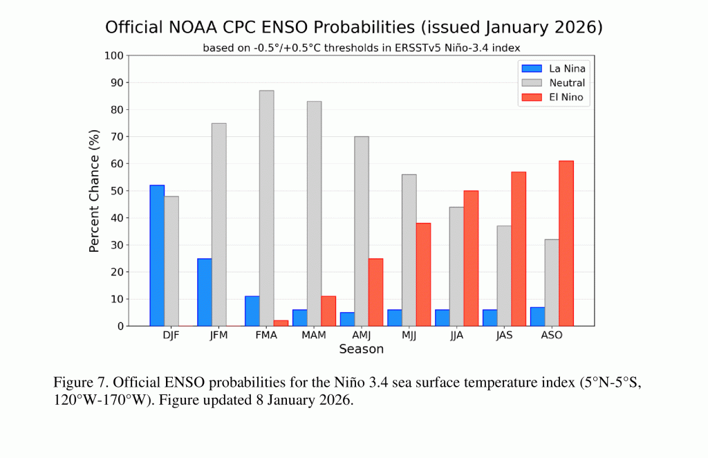
NOAA’s Climate Prediction Center issued its monthly update on ENSO Thursday and CPC forecasters believe the current La Niña should fade over the next month, with the Pacific returning to a state of ENSO-neutral sometime in February or early March. Westerly winds across the western Pacific are forecast to push warm water eastward over the next couple of months, warming sea surface temperatures back into the neutral territory, ending the La Niña by spring.
Late spring into summer, additional warming is predicted and the probability for El Niño summer appears to be increasing. CPC’s update shows a 50 percent or greater probability for El Niño by summer.
Have a great weekend!
Bob
Social Media