Cooler Temperatures Arriving this Weekend. Warm Weather Returns by Tuesday
FEB. 20, 2026
After a week of unseasonably mild temperatures, cooler readings can be expected over the next few days thanks to a couple of cold fronts. The first cold front slid south across the Hill Country and Central Texas regions Thursday night, pulling up stationary near Interstate 10. The front is forecast to remain nearly stationary over this same area through Friday night. Moisture convergence along the boundary may cause a few spotty light showers Friday afternoon from the La Grange and Brenham areas, southeast to the coast. For the rest of the region, Friday’s weather will feature a mostly cloudy sky and slightly cooler temperatures.
- High temperatures Friday are forecast to generally be in the mid-60s. Meanwhile, areas south of the boundary will see highs in the low 80s
- Low temperatures Saturday morning will range from the low 40s across the northern Hill Country, the low and mid-50s across Central Texas, to the low 60s across the coastal plains
The second, stronger cold front is forecast to push south across the region late Friday night into early Saturday morning, The front should move into the Gulf by mid-morning Saturday. Unfortunately, the atmosphere looks to be too dry for the development of any rain along the front. A strong pressure gradient behind the cold front will cause stiff northerly winds with speeds of 10-20 mph and gusts to 30 mph. The breezy conditions are forecast to persist Saturday night through about midday Sunday. Expect a sunny sky and cooler temperatures Saturday through Sunday. In fact, a light freeze will be possible across parts of the Hill Country Sunday and Monday mornings.
- Highs Saturday will range from the mid-60s across the northern Hill Country, to the low 70s across Central Texas, to the upper 70s near the coast
- Highs Sunday will be in the low and mid-60s
- Lows Sunday, Monday, and Tuesday mornings will include the low and mid 30s across the Hill Country, and the upper 30s to 40 degrees across Central Texas and the middle Texas coast
The cooler temperatures will extend through Monday, but a rapid warmup is forecast to begin Tuesday as southerly breezes return to the region. Unseasonably mild readings are predicted Wednesday through next weekend. High temperatures in the mid-70s Tuesday will warm to the mid and upper 80s Wednesday and Thursday. Upper 70s to low 80s are forecast next Friday and next weekend. Low temperatures next week are predicted to be mostly in the 50s.
Next week’s weather is forecast to remain sunny and dry as our region remains under the influence of a broad, stationary ridge of high pressure over northern Mexico and the southwestern U.S. This feature is predicted to remain in place into the first week of March and is expected to cause continued dry and warm weather conditions across Texas.
Fire Weather Concerns
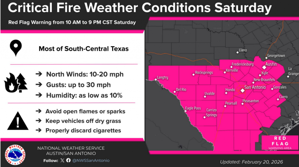
Near critical to possibly critical fire weather conditions are predicted across the region between the late morning to early evening hours Saturday due to the gusty winds and very dry air in the wake of the morning cold front. The Austin-San Antonio National Weather Service office has posted a Red Flag Warning for Central Texas and most of the Hill Country between 10 am and 9 pm Saturday.
Elevated fire weather conditions are also forecast for Sunday as the breezy conditions and dry air continue.
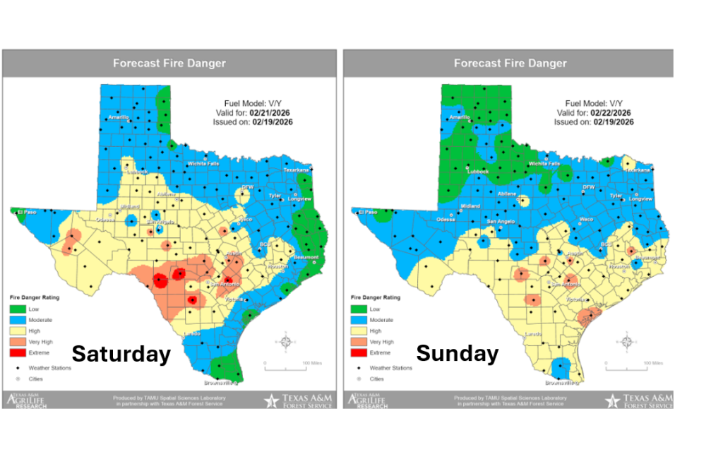
The Texas A&M Forest Service is showing a “high to very high” fire danger forecast for Saturday, and a “high” fire danger for Sunday.
Additional fire weather concerns are expected to develop the middle of next week as breezy conditions and very dry air combine once again.
Updated Outlook for March and March through May
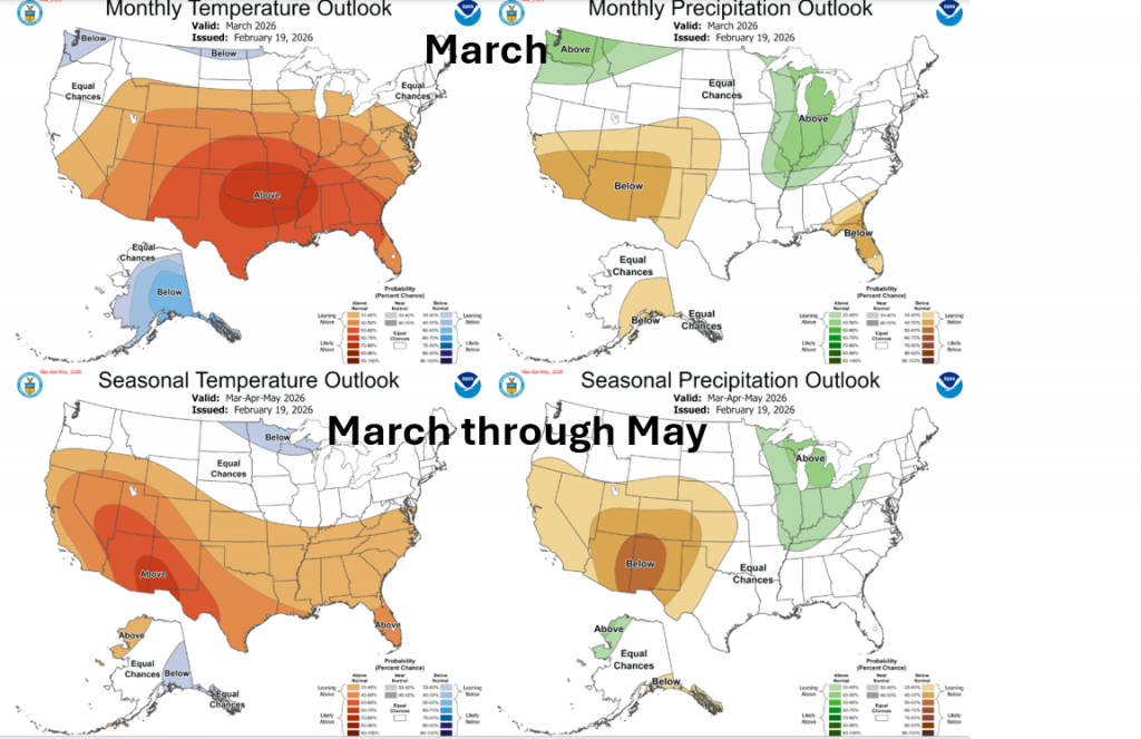
On Thursday, the National Weather Service issued its monthly updated climate outlook. NOAA forecasters noted La Niña is quickly fading and the Pacific should return to ENSO neutral sometime in March. However, a dry signal from La Niña is expected to continue influencing weather conditions across much of Texas through at least the first half of March.
The updated outlooks for March and March through May showed little trend for rainfall due to the uncertainty into how long this influence will last. Some forecast solutions are showing a trend toward more rainfall beginning in April. The temperatures outlook shows strong odds the temperature will average above normal this spring.
Have a great weekend!
Bob
Social Media