Dry Weather with Summer-Like Temperatures Expected for the Next Week
March 20, 2026
On this first day of astronomical spring, Texas remains solidly in the grips of a dry and unseasonably warm weather pattern. This dry and warm pattern is in large part due to the presence of an anomalously strong ridge of high pressure, or heat dome, covering the western half of the U.S. The ridge has pushed the jet stream and storm track well north into southern Canada, while at the same time causing a dry and very stable atmosphere across Texas and the southwestern U.S. On a side note, this ridge is among the strongest ever observed in the month of March across the U.S. Sinking air under the center of the ridge produced dangerously hot temperatures across much of the southwest on Thursday and more dangerous heat is expected through the weekend. Martinez Lake, Arizona recorded a temperature of 110 degrees Thursday, setting a new U.S. record for the hottest March temperature ever recorded.
The western ridge is expected to have an increasing influence on Central and South Texas weather Friday and through the weekend as it expands further to the east. Near record high temperatures are expected through Sunday along with no chance for rain. It will likely feel more like July rather than March.
- High temperatures Friday are forecast to be around 90 degrees across the Hill Country and Central Texas regions
- High temperatures Saturday and Sunday are predicted to be in the mid-90s across the Hill Country and Central Texas, and in the upper 80s across the coastal plains
Slightly lower temperatures are forecast Monday and Tuesday as the western ridge weakens and a weak cold front slides south and stalls over Central Texas. However, very warm readings will return for Wednesday and Thursday as the front dissipates and the center of the weakened western ridge moves over Texas.
- High temperatures Monday and Tuesday look to be near 88-90 degrees across the Hill Country and Central Texas regions, and in the mid-80s across the coastal region
- High temperatures Wednesday and Thursday are forecast to be in the low and mid-90s across the Hill Country and Central Texas regions, and in the upper 80s near the coast
Continued sunny and dry weather with slightly cooler temperatures are predicted next Friday into next weekend when a stronger cold front brings in cooler air. High temperatures are forecast to generally be in the low and mid-80s, with lows in the 50s.
Looking out further into the week of March 30th, long range forecasts call for high temperatures to return to mid and upper 80s, with lows in the 60s.
Dry weather is forecast for the first half of the week. However, some chances for rain are beginning to show up for the second half of the week as the persistent ridge moves away and a southwesterly flow from the Pacific begins to become established across the southwestern U.S. and Texas. Stay tuned for more details in the coming days.
Fire Weather Concerns
Dry air will remain in place across the Hill Country and Central Texas this weekend and into Monday. As temperatures soar the next couple of days, relative humidity levels will drop. Minimum relative humidity readings through Sunday are expected to fall below 30% over most of the area, and below 20% over the area west of Interstate 35. Winds Friday and Saturday are forecast to be near 10 mph but are expected to increase to 10-15 mph with gusts to 25 mph on Sunday. Elevated fire weather conditions are forecast Friday and Saturday and could become near critical on Sunday.
The Texas A&M Forest Service is showing a Very High to near Extreme Fire Danger across much of the region Sunday:
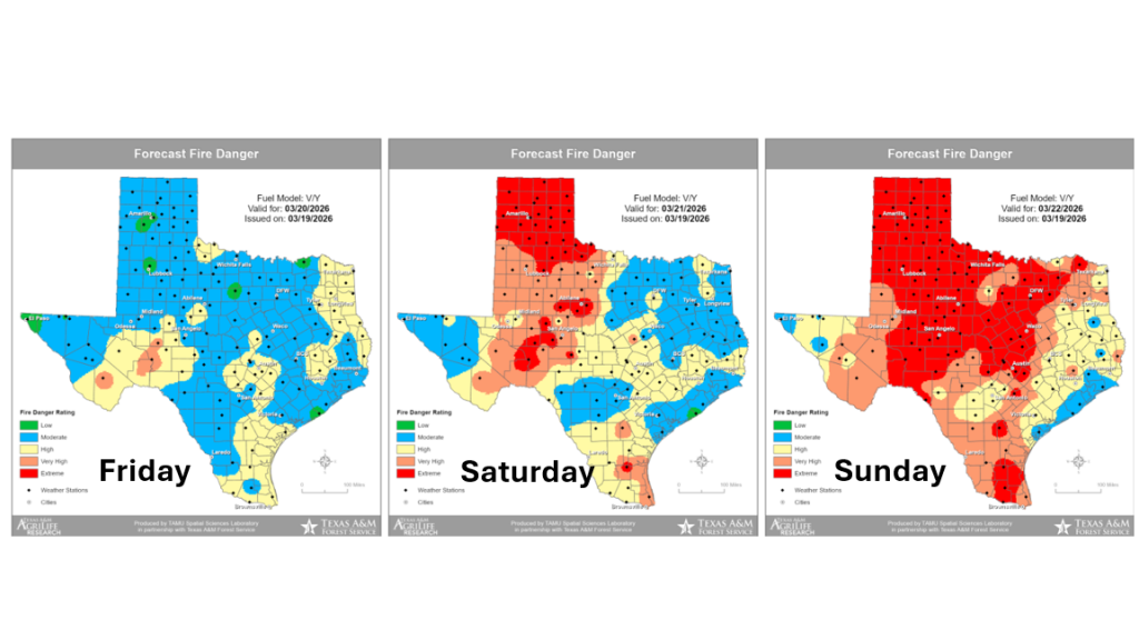
There should be some improvement toward the middle of next week as wind speeds lower.
NOAA’s Updated Weather Outlook for April
On Thursday, NOAA’s Climate Prediction Center updated its monthly outlook for April. The outlook shows temperatures and rainfall leaning above normal for the Hill Country, Central Texas, and the middle Texas coast.
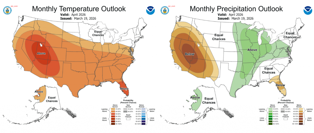
La Niña is fading quickly, and forecasters anticipate a change in the weather pattern taking place in April that will bring more cold fronts and some Pacific storm systems into Texas. These will be very welcome rains and this will be quite a change from the dry pattern we’ve been stuck in since last September.
Have a good weekend!
Bob
Social Media