

Fall-Like Temperatures this Weekend. Warmer Readings Returning Next Week
OCT. 16, 2026
The first strong cold front of autumn moved across the area late Thursday night into early Friday morning, bringing gusty winds and much cooler temperatures! After wearing shorts for the past few months, many folks are now reaching for a light jacket. Cool, fall-like temperatures will be in place through the weekend and early next week, but warmer temperatures will be returning for the second half of next week.
A large area of moderate to heavy rain developed across parts of West Texas, the Edwards Plateau, and the western Hill Country region Thursday night into early Friday morning when the cold front met up significant moisture off the Pacific and the Gulf. LCRA’s Hydromet and Doppler radar estimates show widespread totals of 1.5 to 4 inches falling over the area from Rocksprings, to Menard, Brady, and Brownwood. LCRA’s highest gauged total was 4.28 inches at a location about 15 miles to the west of Brady. There was a sharp gradient to the rain, with little to no rain falling across the eastern Hill Country, Central Texas, and the middle Texas coast.
NWS Estimate of Rain Falling Between 7am Thursday and 7 am Friday:
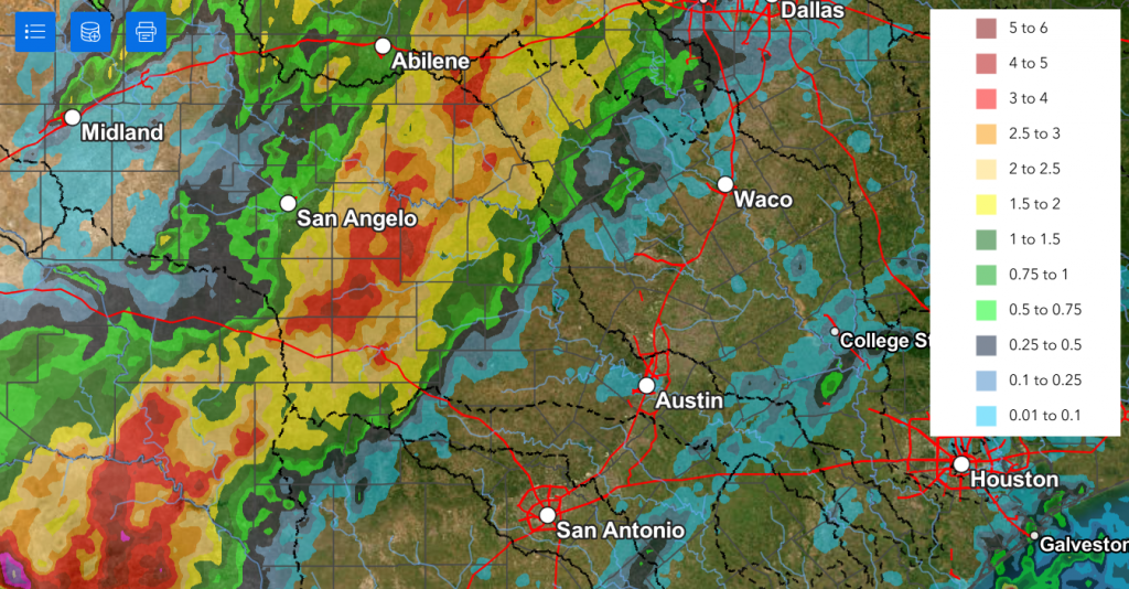
Data courtesy NWS West Gulf River Forecast Center
The strong cold front has moved off the middle Texas coast, and a large dome of Canadian high pressure is beginning to settle into Texas from the southern Rockies. A tight pressure gradient behind the front is expected to keep the winds strong and gusty through Friday night.
- Forecasts call for sustained winds of 15-25 mph with occasional gusts to 40/45 mph through late Friday afternoon
- Winds of 10-20 mph, with occasional gusts to 40 mph are predicted Friday night into early Saturday morning
- Saturday’s wind is forecast to be in the range of 10-15 mph, with occasional gusts to 30 mph through the morning
- Wind speeds should decrease to just 5-10 mph Saturday night through Sunday
The clouds are forecast to slowly decrease with the sky becoming mostly sunny Friday afternoon. This will be followed by a clear sky Friday night and this weekend.
Much cooler temperatures will be the most notable feature for the weekend. The nights will be chilly with lows in the 40s and 50s. The coldest period is expected to be Saturday night into Sunday morning. Some low valleys across the Hill Country could see readings dip into the mid and upper 30s.
- High temperatures Friday will range from the low 60s across the northern Hill Country, to the low 70s across the coastal plains
- High temperatures Saturday are forecast to be in the low and mid-60s across the Hill Country and in the upper 60s at most other locations
- High temperatures Sunday are predicted to generally be near 70-72 degrees
- Low temperatures Saturday morning are forecast to be near 40-42 degrees across the Hill Country, in the upper 40s across Central Texas, and in the low 50s across the coastal plains
- Low temperatures Sunday morning are predicted to be in the low 40s across the Hill Country, the mid and upper 40s across Central Texas, and the upper 40s across the coastal zone
- Lows Monday morning are forecast to be in the mid and upper 40s across the Hill Country, near 50 degrees across Central Texas, and in the low to mid-50s across the coastal counties
The outlook for next week calls for sunny and dry weather throughout the week. A strengthening ridge of high pressure in the upper atmosphere over Texas will cause warming daytime and nighttime temperatures. High temperatures will start off the week in the mid-70s, warm to the mid-80s by Wednesday, reaching into the upper 80s Thursday and Friday. Lows early in the week will be in the 50s, rising into the 60s for the second half of the week.
Long-range forecasts are not very optimistic for rain developing anytime soon. The forecasts do point to a chance for rain possibly developing during the second half of the week of October 26th.
Tropical Weather Outlook
Weather conditions are quiet across the Gulf, Caribbean, and the tropical Atlantic. There are no systems in place which pose a threat for tropical development over the next seven days.
NOAA’s Winter Weather Outlook
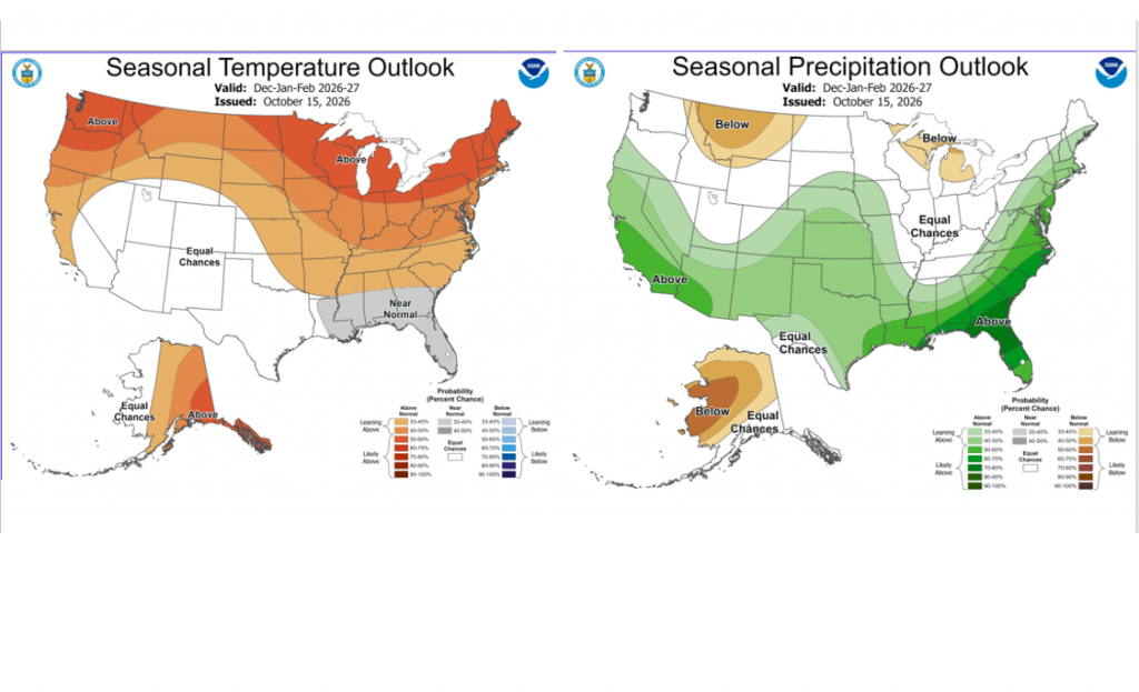
NOAA’s Climate Prediction Center released its update outlook for the upcoming winter on Thursday. The forecasters indicated this winter’s outlook would be heavily influenced by a very strong El Nino that will be in place through spring. A robust subtropical is expected to bring above normal precipitation to Texas and the southern U.S. going into spring. On the temperature side, things are not as clear. Much of Texas is expected to see numerous cloudy, wet days that may help to hold down the temperature. But there will likely be some extended sunny breaks that could produce above normal temperatures. NOAA decided to show equal chances for the temperature to average above-, below-, or near-normal.
Have a great weekend!
Bob
Social Media