

Forecasts Shows No Break from the Heat Over the Next Couple of Weeks
July 6, 2026
Scattered thunderstorms are forecast across this Hill Country Monday afternoon into Monday evening. These storms are the result of a leftover boundary from thunderstorms which developed across Oklahoma late Sunday. This boundary spread south into Northwest Texas Sunday and was situated across the Hill Country and West Texas Monday afternoon. The probability for rain across the Hill Country through Monday evening will be near 40 percent. Some of Monday’s storms may produce strong and gusty winds along with pockets of locally heavy rain. Rain amounts are forecast to average between 0.5 and 1 inch, with isolated totals to near 2 inches possible. This same boundary may bring a few isolated showers or thunderstorms to part of Central Texas Monday afternoon, but most locations should stay dry.
Towards the coast, scattered showers and thunderstorms will be possible through early evening as the sea breeze pushes to the northwest. Spotty totals to around a quarter inch will be possible.
- High temperatures Monday are forecast to be in the upper 80s to low 90s across the western half of the Hill Country, in the mid to upper 90s across the eastern Hill Country and Central Texas regions, and in the low to mid-90s across the coastal plains
Tuesday’s weather will include a 20 percent chance for scattered thunderstorms across the Hill Country due to some remnant boundaries from Monday’s activity. The rest of the region is predicted to be mostly sunny and hot.
- High temperatures Tuesday will include the mid-90s across the Hill Country and coastal regions, and in the upper 90s across Central Texas
Wednesday through Friday, expect a pattern of mostly sunny, dry, and hot weather as our region comes under the influence of a subtropical ridge of high pressure, or heat dome. The center of the heat dome is forecast to be well to our west over southern California.
- Daily high temperatures look to continue in the mid and upper 90s
Scattered showers and thunderstorms will return to the forecast across the region this weekend and next Monday as the center of the heat dome becomes established across the central Rockies, allowing an enhanced area of moisture to spread inland from the Gulf. The probability for rain each day will be near 30-40 percent, with daily rain amounts expected to be around a quarter inch. Some isolated heavier totals will be possible.
- High temperatures Saturday through Monday are forecast to be in the mid-90s across the Hill Country and Central Texas regions, with lower 90s expected towards the coast
Next Tuesday through Friday, the heat dome is forecast to cover much of the southwestern and south-central U.S., with the center or most intense portion setting up over southern Plains. The heat dome is expected to produce a pattern of sunny, dry, and hot weather across the entire region. Look for high temperatures to be in the upper 90s at most locations. High temperatures look to climb close to 100/101 degrees across the Hill Country and Central Texas regions beginning late next week and the following weekend.
Tropical Weather Outlook
Weather conditions remain very quiet across the tropical Atlantic, the Caribbean Sea, and the Gulf. Atmospheric conditions appear unfavorable for tropical cyclone development over the next seven days.
Another Plume of Saharan Dust is Headed Toward Texas
Satellite images show another plume of Saharan dust across the Caribbean that is forecast to approach South Texas on Wednesday. The plume of dust is expected to push farther inland Thursday and is expected to be the primary driver in elevated fine particulate matter across the state, although lingering smoke associated with the burnings in Canada, Mexico, and southwestern CONUS could also play a role. Breezier winds across the eastern two thirds of the state could increase dispersion in that area. The plume of Saharan dust is forecast to linger into Friday, then slowly exit to the north.
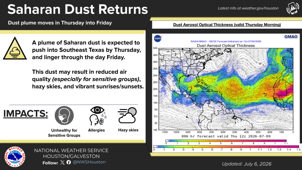
It is interesting to note there are additional plumes of Saharan dust lined up across the tropical Atlantic that are pushing to the west and could move into Texas next week.
Have a good week!
Bob
Social Media