Friday Update on the Upcoming Arctic Outbreak
JAN. 23, 2026
- A Winter Storm Warning has been posted from Saturday morning through midday Sunday
- Significant accumulations of ice expected to occur Saturday into early Sunday
- Dangerously cold temperatures and wind chills are forecast Sunday, continuing into early next week.
- Maximum winterization preparations will be needed for this event to help mitigate infrastructure damage. These actions should be completed Friday afternoon
Bottom Line
A significant winter weather event will bring potentially significant travel and infrastructure impacts as well as bitterly cold temperatures to the Hill Country, Central Texas, and coastal regions beginning Saturday morning and continuing into early next week.
What’s Changed?
There have been minimal changes to the forecast over the past 24 hours other than minor refinements to timing and accumulation estimates. Forecast ice accumulations have gone up slightly compared to Thursday’s outlook.
Discussion
An impactful winter storm is expected to unfold across the state this weekend. As of early Friday afternoon, the leading edge of much colder, arctic air had reached the northern Texas Panhandle, where temperatures have fallen into the teens. Forecasts call for the cold front to slowly sag to the south Friday afternoon and spread across the Hill Country between midnight and daybreak Saturday. The front is forecast to press south across Central Texas from just before daybreak through late Saturday morning. The front is predicted to move across the coastal counties Saturday afternoon.
The temperature is predicted to fall below freezing across most of the Hill Country by about 6 am Saturday, across Central Texas by about mid-afternoon, and across the coastal region by late Saturday evening.
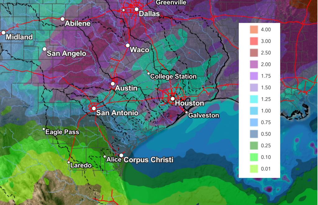
Forecasts continue to call for a widespread area of light to occasionally moderate rain showers to spread across the region Friday night through about midday Saturday, with a second wave of light to moderate precipitation expected Saturday night into Sunday morning. Forecast liquid rain amounts through Sunday morning are predicted to be roughly around 1-1.25 inches. Some higher totals will be possible.
NWS Rainfall Forecast Valid through 6 pm Monday:
The rain is forecast to become a mixture of rain, freezing rain, and sleet across parts of the Hill Country Friday night through Saturday night and early Sunday. Across Central Texas, the rain is forecast to become a mixture of rain and freezing rain and sleet beginning Saturday afternoon, continuing through Sunday morning. Across the coastal plains, a mixture of rain and freezing rain is forecast beginning Saturday evening, continuing through Sunday morning. The precipitation should end from west to east Sunday morning as the system responsible for the precipitation exits our region.
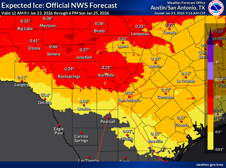
Ice Accumulation
Significant amounts of ice are forecast to develop on trees, power lines, exposed objects, and roads. Recent forecasts have trended up slightly in expected totals. Friday’s data suggests totals through Sunday morning to now be between 0.25 and 0.5 inches across the Hill Country. Across Central Texas and the middle Texas coast, totals are forecast to average between 1/10th and ¼ inch. Some pockets of ½ inch accumulation will be possible. No significant sleet accumulations are forecast.
There hasn’t been any significant change in the temperature forecast. This will likely be a long duration freeze for most of the Hill Country, as the temperature is expected to remain below freezing for at least 72 hours. Across the Austin and Central Texas area, the temperature is predicted to remain below freezing for roughly 48 hours.
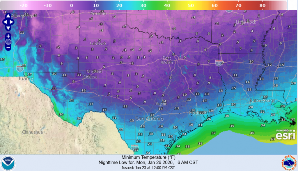
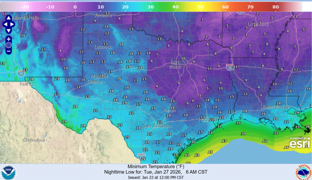
The coldest nights coming upcoming are still expected to be Sunday night and Monday night. Lows Monday and Tuesday morning are forecast to be between 5 and 10 degrees across the Hill Country, between 10 and 15 degrees across Central Texas, and between 15 and 20 degrees across the coastal plains. High temperatures Monday will range from the upper 20s across the Hill Country, to the upper 30s across the coastal region. High temperatures Tuesday are predicted to generally be in the upper 40s.
NWS Forecast of Low Temperatures Monday Morning:
NWS Forecast of Low Temperatures Tuesday Morning:
With hazardous travel conditions commencing Saturday, preparations for hazardous cold and a prolonged freeze should finish up today. Remember to protect the four P`s: People, Pets, Plants, and Pipes.
Bob
Social Media