

Heat Wave Continues. Monitoring a Small Chance for Rain Thursday
AUG. 24, 2026
The hottest temperatures so far this summer occurred over the weekend with readings reaching between 105 and 108 degrees at many locations across the Hill Country and Central Texas. The heat started early and lasted well into the night. At many locations, readings didn’t fall into the 80s until about midnight. Sunday’s high temperature of 107 degrees at Austin-Camp Mabry broke the previous record high temperature for the date of 106 degrees set in 2010.
No significant change in the extreme heat is expected through first half of this week. Monday’s weather maps showed a strong heat dome covering most of the western and central U.S., with the center of the heat dome located over northern New Mexico. Sinking air associated with the heat dome, south and southwesterly down sloping winds out of Mexico, a very dry ground, and a strong August sun will again combine to produce very hot temperatures across the region through mid-week. Forecasts call for the center of the heat dome to shift slightly to the west Tuesday into Wednesday, which may result in the high temperatures lowering 1-2 degrees.
- High temperatures Monday are forecast to be near 104-107 degrees across the Hill Country and Central Texas regions, and near 98-101 degrees across the coastal plains
- High temperatures Tuesday and Wednesday are predicted to be near 102-105 degrees across the Hill Country and Central Texas regions, and in the upper 90s across the coastal plains
- The National Weather Service has posted an Extreme Heat Warning for Travis, Bastrop, Burnet, Llano, and Mills Counties through 7 pm Monday evening
- The National Weather Service has posted a Heat Advisory for the northern Hill Country and all Central Texas through 7 pm Wednesday
A small break in the hot and dry pattern may develop across our region Thursday and Friday. Forecast solutions call for a wave of low pressure to track south across Texas along the eastern periphery of the heat dome Thursday into Friday. This wave of low pressure will try to take advantage of the limited amount of moisture available to produce a few scattered showers and thunderstorms—mainly in the afternoon and evening. The probability for rain across the Hill Country and Central Texas regions will be near 30 percent Thursday and 20 percent Friday. For the coastal region, the probability for rain Thursday will be 20 percent, and 30 percent Friday.
Spotty totals to around a quarter inch are forecast. Unfortunately, most areas will stay dry Thursday and Friday. But note wherever storms do develop, gusty outflow winds, lightning and brief heavy rainfall will be the main concerns. High temperatures Thursday and Friday are predicted to be close to 100 degrees.
This weekend, the heat dome is forecast to become more east-west oriented. As a result, upper-level winds look to become less favorable to bring additional waves of low pressure south into Texas. Sunny, dry, and very hot weather looks to continue.
- High temperatures Friday through Sunday are forecast to be near 98-102 degrees across the Hill Country and Central Texas regions, and near 96-98 degrees across the coastal plains
Unfortunately, no significant change in the hot and dry weather pattern is predicted for next week. Forecast solutions call for the heat dome to remain over Texas and the south-central U.S throughout the week, limiting any chance for rain. There are indications the heat dome will be a little weaker, compared to this week. High temperatures next week are predicted to hold around 100-102 degrees across the Hill Country and Central Texas regions, and in the mid to upper 90s across the coastal plains.
Elevated fire weather conditions will exist across the region this week. Although winds speeds will be fairly light this week, poor overnight relative humidity recovery, critically to extremely dry fuels, and above-average temperatures will support conditions favorable for increased fire activity.
Tropical Weather Outlook
Weather conditions remain quiet across the Gulf and the Caribbean Sea. There are no systems in place here that pose a threat for tropical development over the next week.
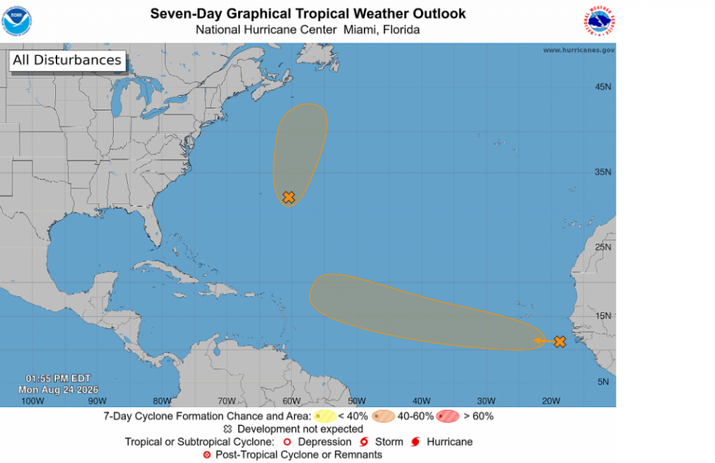
National Hurricane Center forecasters are monitoring a couple of areas in the eastern tropical Atlantic and the central subtropical Atlantic for possible tropical cyclone development.
Out in the far eastern tropical Atlantic, forecasters are tracking a tropical wave and associated area of low pressure centered a few hundred miles southeast of the Cabo Verde islands that is accompanied by disorganized showers and thunderstorms. Environmental conditions are forecast to gradually become more conducive for development, and a tropical depression could form by the middle to latter portions of the week as the system moves westward to west-northwestward at 15 to 20 mph across the eastern and central tropical Atlantic. NHC is giving this system a 60 percent chance for tropical development over the next seven days.
Forecasters are also monitoring an area of low pressure over the central subtropical Atlantic, a few hundred miles southeast of Bermuda. Satellite-wind data Monday morning indicated that the low-level circulation remains rather broad. Environmental conditions are only marginally conducive for further development, but this system could become a short-lived tropical depression or storm through Tuesday while it moves northward and north-northeastward, well to the northeast of Bermuda. By Wednesday, the low is forecast to move over cold waters, ending its formation chances. NHC ius giving this system a 50 percent chance for tropical development over the next 48 hours.
A Partial Lunar Eclipse Will Be Visible Thursday Night
Earth’s shadow will swallow 96% of the lunar surface overnight on Aug. 27-28, potentially turning the moon a gorgeous shade of crimson as it bathes in light filtered and refracted by our planet’s atmosphere. The partial lunar eclipse will occur as Earth passes between the sun and moon during the monthly full moon phase. Around this time, Earth’s curved inner shadow will appear to creep across the lunar surface while leaving a very thin crescent exposed to direct sunlight at the point of maximum eclipse.
The eclipse will be visible across all Texas.
The eclipse will begin at 9:33 pm CDT. Maximum eclipse, where 96 percent of the moon will be covered by Earth’s shadow, will begin at 11:12 pm and run through 12:51 am. The eclipse will end at 2:01 am.
You also won’t need safety glasses or specialized equipment to view the lunar eclipse. It’ll look magnificent to the naked eye, though binoculars, or even a telescope can heighten the experience by granting a magnified view of the moon as Earth’s shadow slowly marches across its cratered surface!
Have a great week!
Bob
Social Media