Increasing Chances for Rain and Storms Thursday and Friday. Turning Cooler Late Week
April 27, 2026
Unseasonably warm and muggy conditions will be in place through the middle of the week before widespread, soaking rains and cooler air move in late week behind a pair of cold fronts.
Monday afternoon through Tuesday night, little change in the weather is predicted across our region. While the atmosphere will be quite moist and unstable, a large area of warm air, or cap in the middle atmosphere, is expected to keep a lid on any thunderstorms which might want to develop. The West Texas dry line is forecast to push east into the Hill Country on both days, but the cap should limit thunderstorm development. There’s a very low-end chance a couple of isolated thunderstorms could form over the Edwards Plateau late Monday evening and again Tuesday evening, but the chance for rain here will be less than 20 percent.
Expect widespread nighttime and morning clouds, followed by a partly cloudy sky both afternoons. High temperatures both days will be near 90-92 degrees. Light southerly breezes Monday afternoon and Monday night will increase to 10-15 mph on Tuesday.
Changes in the weather are predicted to take place beginning Wednesday when a weak cold front pushes south out of Northwest Texas. The front is forecast to spread southeast across the Hill Country Wednesday morning and through Central Texas Wednesday afternoon, pulling up stationary near Interstate 10 Wednesday evening. There will be a slight chance for a few showers and thunderstorms along and behind the front across the Hill Country and Central Texas regions Wednesday into Wednesday night. The probability for rain will be near 30 percent. There will be a low risk some of these storms may be strong to severe. The Storm Prediction Center has placed most of the region under a 1 out of 5 risk for severe storms Wednesday and Wednesday night. The greatest threats will be large hail and damaging winds.
Wednesday’s temperature will trend a little cooler for areas behind the cold front. Expect highs here to be near 80 degrees. Meanwhile, highs across the coastal region are predicted to remain in the low 90s.
The chance for rain showers and thunderstorms will increase across the area Thursday through Friday as a trough of low pressure begins to track northeast out of the Desert Southwest. Atmospheric lift out ahead of the approaching trough is expected to pull considerable Gulf moisture north over the stalled cold front. Showers and scattered thunderstorms are expected to increase in coverage and intensity throughout the day Thursday, with multiple rounds of rain continuing Thursday night through Friday night. The probability for rain will be near 70 percent. As of now, the chance for severe storms Thursday and Friday appears low. Light showers and a few thunderstorms look to continue Friday night into Saturday morning. All the rain is forecast to end by midday Saturday as the upper trough exits to the northeast.
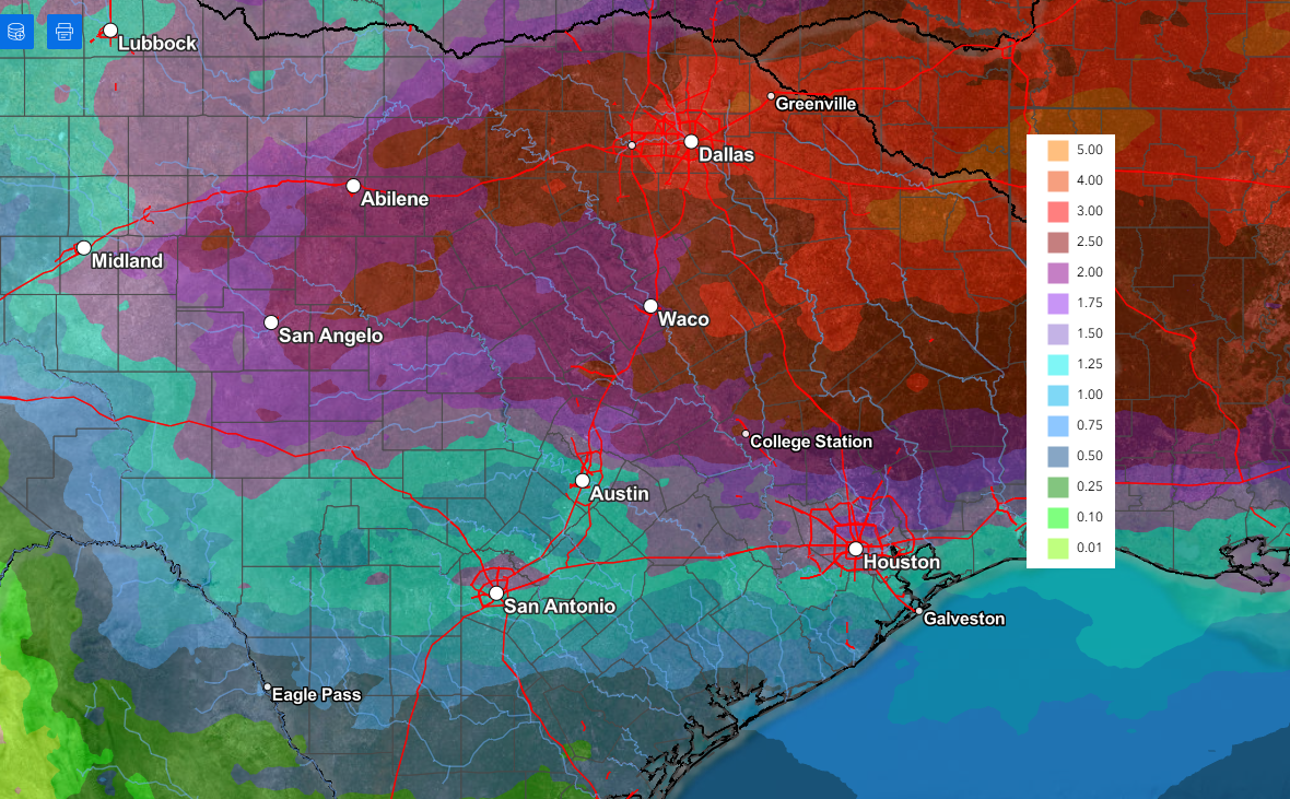
Forecasts are pointing toward the possibility for some significant totals of rain—especially across the Hill Country week.
National Weather Service rainfall forecasts through Saturday evening call for general totals of 1-3 inches across the Hill Country, and between 1 and 2 inches for most other locations.
NWS Rainfall Forecast Valid through 7 pm Saturday:
Much cooler air is forecast to spread across the area behind a second cold front Friday and Friday night! The cool air is expected to remain across the area through the weekend.
- High temperatures Friday are forecast to be in the mid and upper 60s across the Hill Country and Central Texas regions, and in the mid-70s towards the coast
- High temperatures Saturday will be in the upper 60s to low 70s
- High temperatures Sunday are predicted to be in the low and mid-70s
- Lows Saturday morning will range from the upper 40s across the Hill Country, the upper 50s near the coast
- Lows Sunday morning will include the mid-40s across the Hill Country, the upper 40s across Central Texas, and the lower 50s across the coastal region
- Lows Monday morning are forecast to be in the low and mid-50s
Clouds should clear Saturday afternoon, followed by sunny weather on Sunday.
Looking ahead to next week, sunny and dry weather is forecast Monday through Wednesday. However, a chance for rain showers and thunderstorms will return to the forecast for Thursday and Friday as another trough of low pressure approaches from the west.
High temperatures next week are predicted to generally be in the mid and upper 80s.
Have a great week!
Bob
Social Media