Little to No Rain Expected through Next Week. Near-Normal Temperatures Forecast
JAN. 12, 2026
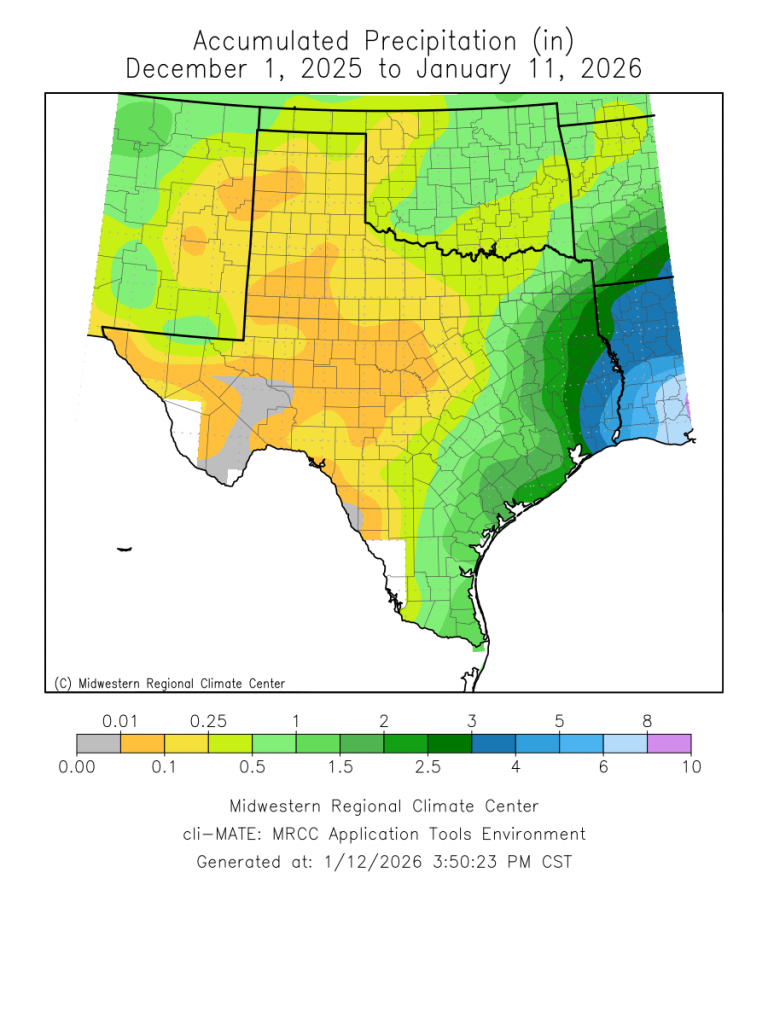
Weather conditions look to stay quiet this week. Although a couple of cold fronts are predicted to move across the area, temperatures are not expected to trend all that cold. Unfortunately, little to no rain is forecast this week and the upcoming weekend as the storm track stays well to the north of Texas. Austin’s last rain with totals of an inch or more was nearly three months ago on October 24th and 25th. It has been a very dry fall and winter.
Monday’s satellite images showed a steady stream of middle and high-level clouds spreading across Texas out of northern Mexico. These clouds are being generated by a weak trough of low pressure over northern Mexico that is moving northeast. The trough is forecast to move over Central Texas Tuesday morning. The system may generate some very light rain showers across the Hill Country, Central Texas, and coastal regions Monday night into Tuesday morning. However, with the lower atmosphere being so dry, most of the activity will be likely high-based and will evaporate prior to reaching the ground. Any rain that happens to make it to the ground is not expected to total more than a few hundredths of an inch. The probability for rain Monday night through midday Tuesday will only be near 20-30 percent. Clouds should clear from west to east Tuesday afternoon as the upper trough exits to the northeast.
No significant change in the temperature is forecast Monday through Tuesday. High temperature both days will range from the upper 50s across the Hill Country, the mid-60s near the coast. Lows Tuesday and Wednesday mornings will generally be in the low and mid-40s.
Wednesday is shaping up to be the warmest day of the week as southerly breezes develop ahead of another Canadian cold front. Under a sunny sky, high temperatures will range from the mid-60s north, to the low 70s across Central Texas and the coastal plains. The cold front is forecast to move across the area late morning through late afternoon. Behind the front, breezy conditions will develop with northerly winds around 15-20 mph and gusts to 30 mph. These breezy conditions look to continue through Wednesday night. Sunny and dry weather will follow Thursday and Friday.
Slightly cooler temperatures are forecast Thursday into Friday. Highs Thursday are forecast to be in the low 60s, warming to the mid and upper 60s on Friday. Lows Thursday and Friday mornings will include the mid-30s across the Hill Country and the upper 30s at most other locations.
Yet another dry, Canadian cold front is predicted to push south across our region Friday evening and Friday night. This front is forecast to reinforce the cool-ish temperatures already in place. Under a sunny sky, expect highs in the low and mid-60s, with lows in the mid and upper 30s.
Next Week
The outlook for next week calls for few changes in the dry and mild weather pattern as Texas remains sandwiched between a trough of low pressure over the Great Lakes region and a broad ridge of high pressure over the western US. The storm track is predicted to remain to the north of Texas. High temperatures next week are forecast to be in the 60s and low 70s, with lows in the 40s and 50s.
An Unusually Mild Start to the Year
The first 11 days of January have been unusually mild across Texas, with the temperature averaging more than 9 degrees above normal at most locations! In Austin, Camp Mabry’s temperature has averaged 10.9 degrees above normal. This ranks as the third warmest January 1-11 on record!

This has also been one of the driest winters on record. Since December 1st, Austin-Camp Mabry has only measured 0.31 inches of rain. In the historical records, this is the 5th driest such period on record.
Have a good week!
Bob
Social Media