

Milder Temperatures Returning this Week. A Slight Chance for Rain this Weekend.
NOV. 16, 2026
Widespread rain showers and a few scattered thunderstorms spread across the region late Saturday through Sunday. For most areas, it was a good, beneficial, soaking rain. Unlike last weekend’s rain, where the highest totals occurred across the western Hill Country, this weekend’s highest totals occurred along the Interstate 35 corridor and along the immediate coast. LCRA’s Hydromet and Doppler radar estimates through 6 am Monday showed most totals averaged less than an inch across the western half of the Hill Country, and between 1 and 1.5 inches across the eastern half. Across Central Texas, amounts generally averaged between 1 and 2 inches, with many totals in the Austin/Travis County area averaging between 2 and 2.5 inches. Meanwhile, the highest totals of the weekend occurred along the coastal area of Matagorda and Brazoria Counties, where amounts averaged between 2.5 and 3.5 inches.
NWS Estimate of Rain Falling Between 6 am Saturday and 6 am Monday:
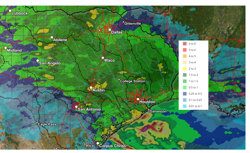
Data courtesy NWS West Gulf River Forecast Center
The trough of low pressure responsible for this weekend’s rain has exited to the northeast, taking the chance for rain with it. Clouds have been clearing from east to west behind the departing system. As of early Monday afternoon, the clearing line had reached the Interstate 35 corridor. The sky is forecast to clear across the Hill Country Monday evening. With a clear sky and light winds in place Monday night, conditions appear favorable to produce one of the chilliest nights so far this autumn.
- Low temperatures Tuesday morning will include the upper 30s across the Hill Country, the lower 40s across Central Texas, and the middle-40s across the coastal plains
Mostly sunny and dry weather is forecast across the region Tuesday through Friday as a weak ridge of high pressure spreads over Texas from the west. Chilly temperatures are forecast to occur again Tuesday night, followed by milder readings for the remainder of the week.
- High temperatures Tuesday will generally be in the low and mid-60s
- High temperatures Wednesday are forecast to be in the upper 60s to 70 degrees
- High temperatures Thursday and Friday are predicted to be in the low and mid-70s
- Lows Wednesday morning are forecast to be in the low and mid-40s across the Hill Country and Central Texas regions, with upper 40s coastal area
- Lows Thursday and Friday mornings are predicted to be in the low and mid-50s across the Hill Country and Central Texas, with upper 50s towards the coast
This coming weekend, clouds and moisture are forecast to spread north from the Gulf ahead of a trough of low pressure lifting northeast from the southern Rockies to northern Plains states. Expect a partly cloudy sky Saturday and a mostly cloudy sky Sunday. The trough is expected to push a Pacfiic cold front into Texas by Sunday, with the front expected to stall somewhere over Central Texas. With moisture increasing ahead of the front and the subtropical jet over our area, there will be a slight chance for a few rain showers and isolated thunderstorms Sunday into next Monday. The probability for rain will only be at 20 percent. Rain amounts are forecast to total less than a quarter inch. High temperatures Saturday and Sunday are predicted to be in the low and mid-70s. Lows Saturday and Sunday mornings are forecast to be in the 50s.
…Outlook for the Week of Thanksgiving…
The outlook for next week calls for several changes in the weather throughout the week as a couple of troughs of low pressure push east out of the central and southern Rockies. As of now, no significant cold outbreaks are predicted through the period.
The first trough of low pressure is forecast to bring a chance for rain showers and scattered thunderstorms to our region next Tuesday into Wednesday. Rain amounts are predicted to be in the range of 0.5 to 1 inch. Mostly sunny and dry weather looks to follow Thanksgiving Day and the following Friday. The second trough of low pressure is forecast to push east across the Plains next weekend, bringing little to no rain to Central and South Texas.
- High temperatures next Tuesday through Friday are forecast to generally be in the mid and upper 60s
- Low temperatures next Tuesday and Wednesday mornings are predicted to be in the 50s
- Low temperatures next Thursday through Saturday mornings are forecast to generally be in the mid and upper 40s
Tropical Weather Outlook
Weather conditions remain quiet across the tropical Atlantic and tropical cyclone development is not expected over the next seven days.
The Leonid Meteor Shower Tuesday and Wednesday Mornings
The Leonid meteor shower will peak the during the early mornings of November 17 and 18. The shower’s radiant will be in the eastern sky is right beside the planets Mars and Jupiter. Forecasters expect about 10 meteors per hour during the dark hours just before sunrise on both dates. Choose a viewing location away from bright city lights, allow approximately 30 minutes for your eyes to adjust to the darkness, and find a comfortable position that gives you a broad view of the sky.
The source of the Leonids is Comet 55P/Tempel-Tuttle, which sometimes causes intense meteor storms with thousands of shooting stars. This is not a storm year for the Leonids, but even a handful streaking past the two planets is worth waking up for.
Have a great week!
Bob
Social Media