Milder Temperatures with Little to No Rain Expected this Week
FEB. 2, 2026
After a week of much colder than normal temperatures, a milder weather pattern is quickly taking shape for most of Texas. The arctic high-pressure system which delivered the latest punch of cold air over the weekend has moved to the southeastern U.S. This has caused a return of mild, southerly winds to Central and South Texas. In addition to this development, the position of the jet stream has begun to change across western Canada and the western U.S. that will turn off the flow of additional arctic air into Texas, at least for the next couple of weeks.
A partly cloudy sky Monday afternoon will become cloudy Monday night as Gulf moisture spreads north ahead of a trough of low pressure over the southern Rockies. The trough is forecast to track southeast Monday night and Tuesday and will drag a weak cold front across Texas. The front is predicted to move across the Austin area Tuesday afternoon, then push off the middle Texas coast Tuesday night. With limited moisture convergence along the front, no rain is expected across the Hill Country or Central Texas regions. However, areas south of Interstate 10 will see a 30-40 percent chance for scattered showers Tuesday evening along the front. Rain amounts, if any, should total less than a quarter inch. Tuesday’s weather will feature widespread clouds in the morning, followed by a partly cloudy sky in the afternoon.
Tuesday’s cold front is not expected to cause much of a change in the temperature:
- High temperatures Monday will include the mid and upper 60s across the Hill Country and Central Texas regions, and be close to 70 degrees across the coastal plains
- Lows Tuesday morning will range from the low 50s across the Hill Country, to the upper 50s near the coast
- High temperatures Tuesday are forecast to be in the mid-60s across the Hill Country, be near 70 degrees across Central Texas, and into the mid-70s across the coastal plains
- Lows Wednesday morning are forecast to be in the mid and upper 30s Hill Country, in the low 40s across Central Texas, and in the mid to upper 40s across the coastal area
Sunny weather and just slightly cooler temperatures are forecast for Wednesday and Thursday. High temperatures both days are predicted to be in the mid-60s. Lows Thursday morning will range from the low 30s across the Hill Country, to around 40 degrees towards the coast.
For Friday through Sunday, the sky will stay mostly sunny. High and low temperatures are expected to trend warmer as southerly breezes return off the Gulf. Daily high temperatures are forecast to be in the mid and upper 70s. Lows Friday and Saturday mornings will be in the 40s, while lows Sunday and Monday mornings look to be around 50 degrees.
Next Week
A chance for scattered rain showers and thunderstorms is forecast to take shape Monday when a trough of low-pressure tracks northeast out of northern Mexico. Dry weather should return for next Tuesday and Wednesday. Another chance for showers appears possible late next week when a trough approaches Texas from the west.
Temperatures next week are forecast to remain mild, with highs in the 70s, and lows in the 50s.
No additional arctic air is forecast through the middle of the month.
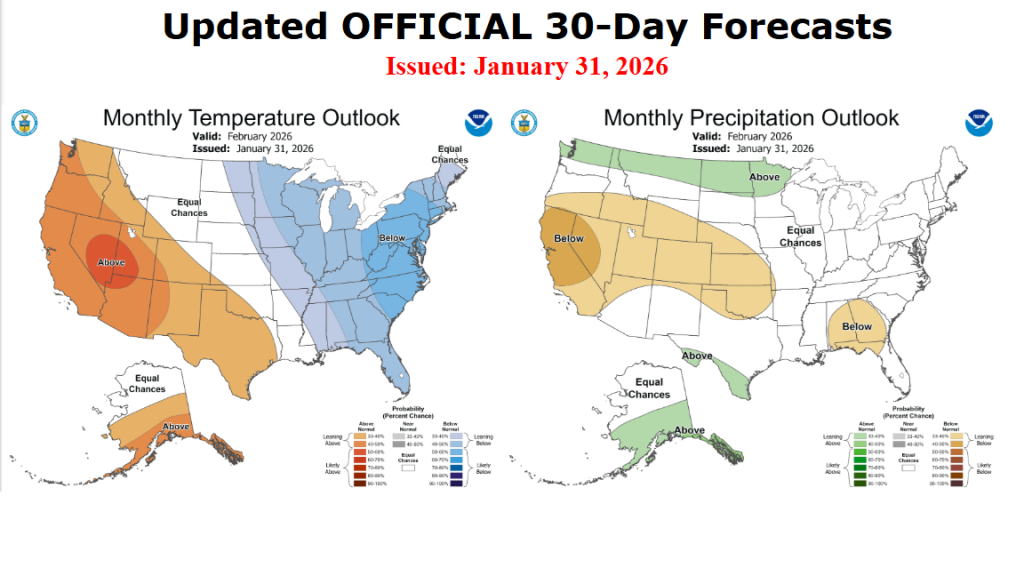
Updated Outlook for February
On Saturday, NOAA’s Climate Prediction Center issued an updated outlook for the month of February. The new outlook still calls for the temperature to lean above normal. For precipitation, the outlook is showing little trend for above-, below-, or near-normal precipitation. CPC forecasters noted this winter’s La Niña is quickly weakening, and this could allow for more Pacific storm systems to move across Texas during the month, leading to periodic chances for rain.
Have a good week!
Bob
Social Media