

Moderate to Heavy Rains Expected to Develop Late Wednesday through Friday
SEPT. 28, 2026
Significant changes in the weather will take place this week that are expected to cause periods of widespread, heavy rain and possible flooding across the region Wednesday through Friday. This weather change is also expected to finally put an end to the persistent summer-like temperatures we’ve had in place since August.
Monday afternoon through Tuesday night, the weather is expected to stay generally dry and quiet across the region. A few isolated rain showers and thunderstorms will be possible across the western Hill Country and the middle Texas coast Monday and Tuesday afternoons. However, rain amounts, if any, should average less than a quarter inch. In general, expect a mostly sunny to partly cloudy sky with high temperatures in the mid and upper 90s. Southerly breezes are forecast to increase to 10-15 mph with occasional gusts to 25 mph on Tuesday.
Starting Wednesday, ingredients appear to be coming together that will have the potential to bring periods of heavy rain and potential flash flooding to our region. Forecasters are closely monitoring a Pacific trough of low pressure that is currently pushing inland over California. This trough is predicted to track east this week, finally moving the persistent heat dome away from Texas. Forecasters will also be following the progress of Major Pacific Hurricane Polo that should make landfall along the coast of Baja, California Monday evening and the northwestern Mexican mainland Tuesday morning. Polo’s remnants are expected to merge with the approaching Pacific trough as it moves across the southern Plains. By Wednesday morning, the combination of strong atmospheric lift ahead of the trough, Polo’s remnant mid and high-level moisture, and significant moisture streaming inland from the Gulf will create a very moist and unstable atmosphere across much of the state.
One additional key feature that will play an important role in determining the location of this week’s widespread rains will be a Pacific cold front tied to the upper trough. The heaviest rains are forecast to develop just ahead of an along the cold front. Forecasts call for the cold front to move into West Texas on Wednesday, then slowly push east to the Hill Country on Thursday, reaching the Interstate 35 corridor sometime late Thursday into Thursday night. The front is forecast to slowly track southeast towards the coast on Friday. Confidence in the timing of the cold front is not all that high at this point. The front may end up moving a slower than is currently predicted above.
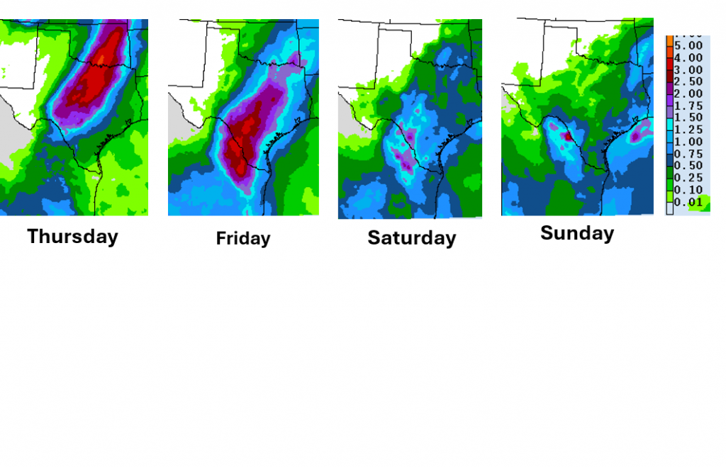
Scattered rain showers and thunderstorms are forecast to increase across the area Wednesday as the atmosphere grows increasingly moist and unstable. A southwest to northeast oriented band of moderate to heavy rain is forecast to develop Wednesday night across the Edwards Plateau, with the area of rain slowly spreading east across the Hill Country Thursday, reaching the Austin/Interstate 35 corridor late Thursday, and the area from La Grange south to the coast Thursday night into Friday morning. Periods of lighter rain and scattered thunderstorms are forecast to continue across the region Friday through Sunday as the trough slowly tracks to the east.
The National Weather Service’s Daily Forecast for Rain:
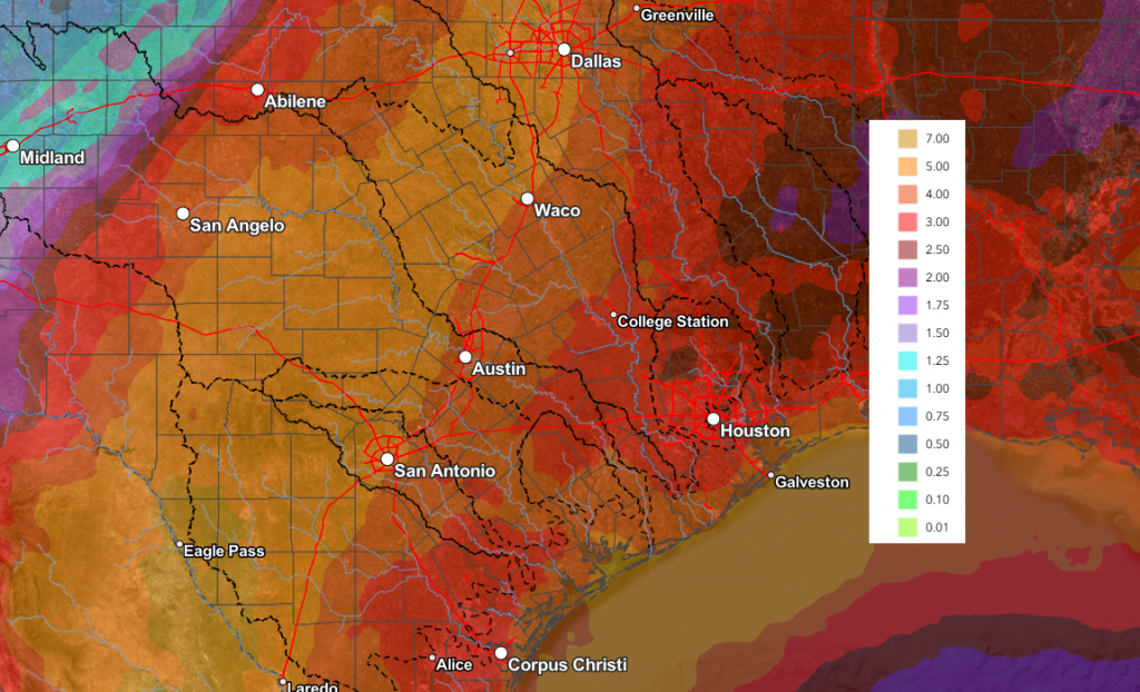
Rainfall forecasts call for the heaviest rains to occur Wednesday night through Friday, with lighter rains continuing through the weekend. Total rain amounts through weekend are forecast to generally average between 4 and 7 inches across the Hill Country, and between 4 and 6 inches for most other locations. Some isolated heavier totals will also be possible. The forecast totals could go a little higher or lower as we get closer to the rain event.
NWS Rainfall Forecast Valid through 6 pm next Monday, 10/5
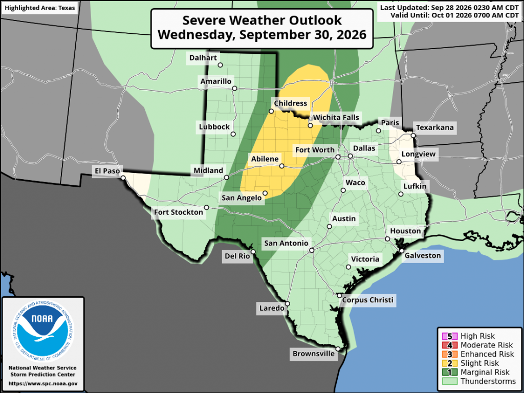
One additional item to note about the rain event, some of the storms moving across West Texas and the northern Hill Country Wednesday could be strong to severe. The Storm Prediction Center has placed this area under a Marginal to Slight Risk for severe thunderstorms. Large hail and damaging winds will be the greatest severe weather threats.
Temperatures are predicted to trend lower beginning Thursday due to the widespread clouds and rain. Expect highs in the mid-80s to 90 degrees. Slightly cooler air will filter in behind the front Friday and through the weekend, with highs generally in the low and mid-80s, with lows in the upper 60s to low 70s.
The outlook for next week calls for mostly sunny and dry weather. Expect high temperatures to be in the mid and upper 80s, with lows in the 60s.
Bob
Social Media