

Monitoring the Threat for Heavy Rain Thursday and Friday
SEPT. 29, 2026
Tuesday’s forecast solutions are not showing any significant changes compared to what was shown on Monday. A large area of slow-moving showers and thunderstorms is forecast to spread across the region late Wednesday night through Friday, with additional lighter rains lingering Saturday into Sunday. Significant totals of rain are forecast over the next few days—especially across the Hill Country and the Interstate 35 corridor. The heavy rain will increase the threat for flash flooding across the area.
A strong trough a of low pressure pushing east out the Desert Southwest, a slow-moving cold front, and very high amounts of Gulf and Pacific moisture and are all forecast to come together across Texas beginning late Wednesday, resulting in the development widespread, moderate to heavy rain. Forecasters will be closely monitoring the progress of this cold front as the heaviest rains are forecast to develop ahead of and along the front. The front will be moving slowly, entering the western Hill Country early Thursday morning. The boundary is forecast to push east across the Hill Country during the day, reaching the Interstate 35 corridor sometime Thursday evening and the coastal plains region Friday morning into Friday afternoon.
High-resolution forecasts call for a large area of showers and thunderstorms to develop across the Concho Valley and the Rio Grande Plains Wednesday night, with the area of rain spreading east into the Hill Country early Thursday morning. The area of rain is forecast to slowly spread east to the Interstate 35 corridor Thursday into Thursday night and the coastal plains region Thursday night into Friday morning. Lighter rains are forecast across the Hill Country on Friday.
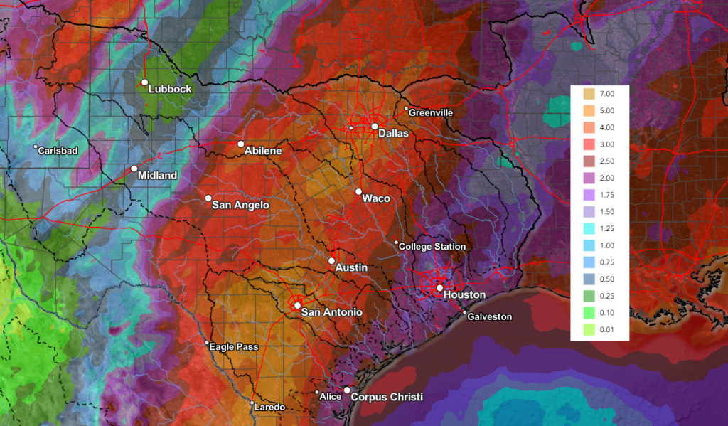
Rain amounts from Wednesday night through Friday evening are forecast to generally average between 2 and 4 inches across the region, with isolated totals of 6 to 8 inches possible. The National Weather Service has posted a Flood Watch for the Hill Country and Central Texas regions from Wednesday evening through Friday evening.
National Weather Service Rainfall Forecast Valid through 7 pm Sunday:
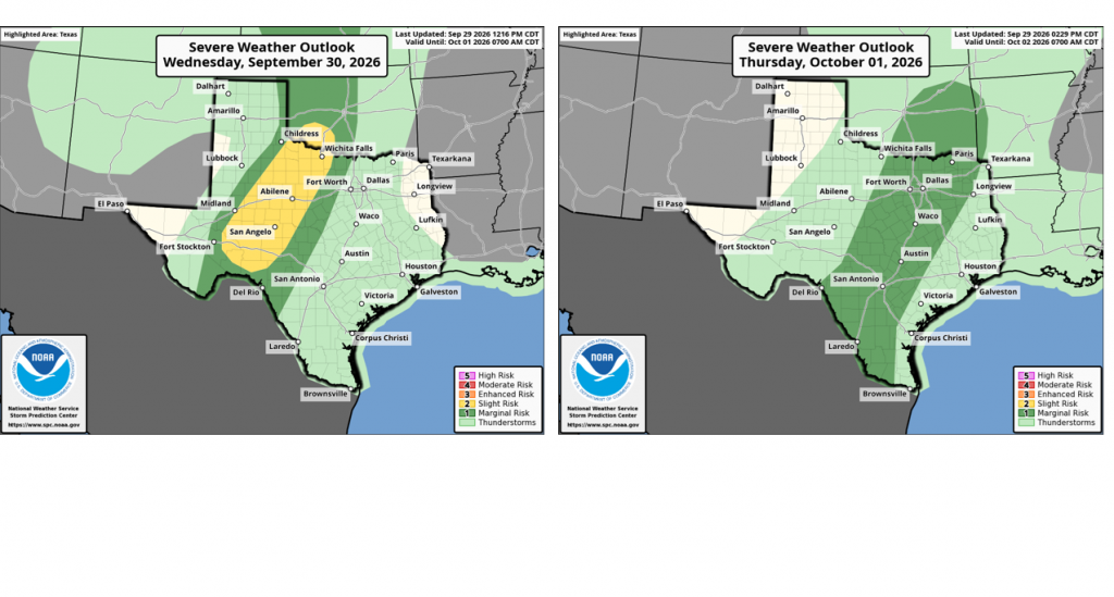
Forecasts continue to show a low-end chance for some of the thunderstorms to be strong to severe Wednesday night through Thursday. SPC forecasters have placed the Hill Country and Central Texas under a 1 out of 5 risk for severe thunderstorms through Thursday night. Large hail and damaging winds look to be the greatest severe threats.
A second trough of low pressure developing over northern Mexico on Friday is expected to keep a chance for rain going through the weekend. This rain is not expected to be nearly as heavy as what is forecast for Thursday and Friday. Periods of light to moderate rain are forecast. The probability for rain will be near 70 percent Saturday, 60 percent Sunday, and 20 percent on Monday. Sunny and dry weather is forecast next Tuesday through Friday.
High temperatures look to trend a little cooler behind this week’s cold front. High temperatures Friday through Sunday are predicted to generally be in the low 80s, with lows in the upper 60s. Similar readings are expected for next week.
Bob
Social Media