Periods of Rain and Thunderstorms Expected through the Middle of Next Week
March 5, 2026
We’ve seen the change to a more unsettled weather pattern take place since Wednesday as the persistent ridge of high pressure over our area weakened and shifted to the east. A trough of low pressure currently pushing east across the southern Rockies will be the big weather maker for our region over the next few days as the trough splits and hangs around around our area. Dry weather looks to return beginning next Thursday.
Late Thursday afternoon through Thursday night, generally quiet weather can be expected for the eastern Hill Country and areas along and east of Interstate 35. To our west, scattered thunderstorms are forecast to develop late Thursday afternoon along the Dry Line over the area between Del Rio and San Angelo. These storms are predicted to spread to the east, possibly reaching as far east as Rock Springs, Junction, and Brady late Thursday evening. Some of the storms could be strong to severe, producing large hail and damaging winds. The storms are expected to weaken and dissipate around midnight as atmospheric conditions stabilize. Elsewhere, a few spotty light rain showers may develop overnight in the warm and moist flow off the Gulf.
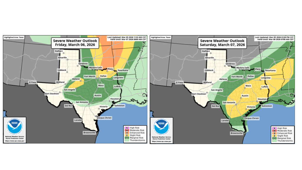
For Friday, the most active area of weather is predicted to be for areas along and west of Interstate 35. Forecasts call for the Dry Line to push out of West Texas and into the Hill Country Friday afternoon. Atmospheric conditions appear favorable for the development of scattered thunderstorms along the Dry Line across the Hill Country region Friday afternoon and evening. The probability for rain and thunderstorms will be near 50 percent. Across the Austin and Central Texas region, there will be a 30 percent chance for scattered air mass rain showers and thunderstorms Friday afternoon and evening. Some of the thunderstorms across both regions will have the potential to become strong to severe. The Storm Prediction Center has placed all the Hill Country and the I-35 corridor under a 1 out of 5 risk for severe storms through Friday night. Large hail and damaging winds will be the primary severe weather threats. Rain amounts through Friday night are forecast to generally average less than a half inch, with some isolated higher totals.
Saturday is shaping up to be a wet and potentially stormy day as the trough to our north pushes a weak cold front south through the region. Forecasts call for the cold front to reach the northwest Hill Country around daybreak Saturday, the Austin/I-35 corridor early Saturday afternoon, and the coastal plains region Saturday night. Abundant Gulf moisture combined with weak atmospheric lift from the cold front and the upper trough is expected to produce a widespread area of rain and scattered thunderstorms across the entire region beginning Saturday morning, continuing Saturday night through Sunday morning. The chance for rain is forecast to decrease Sunday morning across the Hill Country and Central Texas regions as the upper trough pulls off to the northeast.
While a strong to severe thunderstorm cannot be ruled out on Saturday, the main concern is expected to be periods of moderate to heavy rain which could lead to flash flooding. Due to the abundant Gulf moisture in place, significant totals of rain will be possible.
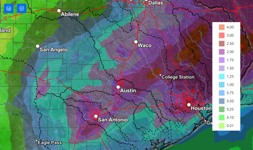
The National Weather Service rainfall forecast through Sunday calls for widespread totals between 1 and 3 inches. Some isolated totals of 4-5 inches will also be possible.
NWS Rainfall Forecast Valid through 7 pm Sunday:
The Storm Prediction Center has placed most of the region under a 2 out of 5 risk for severe thunderstorms Saturday:
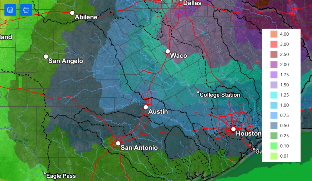
Forecasts call for periods of rain and thunderstorms to continue next Monday through Wednesday as a portion of the Rockies trough of low pressure hangs back and sinks south to northern Mexico. The trough is forecast to finally lift northeast and across Texas next Tuesday through Wednesday, causing another period of widespread moderate rain and scattered thunderstorms. As of now, forecasts call for additional totals of 0.5 to 1.5 inches.
NWS Rainfall Forecast for the Period 7 pm Tuesday through 7pm Thursday:
Dry and slightly cooler weather is predicted next Thursday and Friday in the wake of this system.
Bob
Social Media