

Periods of Rain Will Continue through the Weekend. Dry Weather Returns Monday
OCT. 2, 2026
Key Messages
- Periods of light to moderate rain and isolated thunderstorms will continue across the region Friday night through Sunday
- Some of the most persistent rains on Saturday are forecast to occur across the Hill Country
- The coverage and intensity of the rain is expected to decrease Sunday
- The National Weather Service will allow the Flood Watch to expire at 7 pm Friday
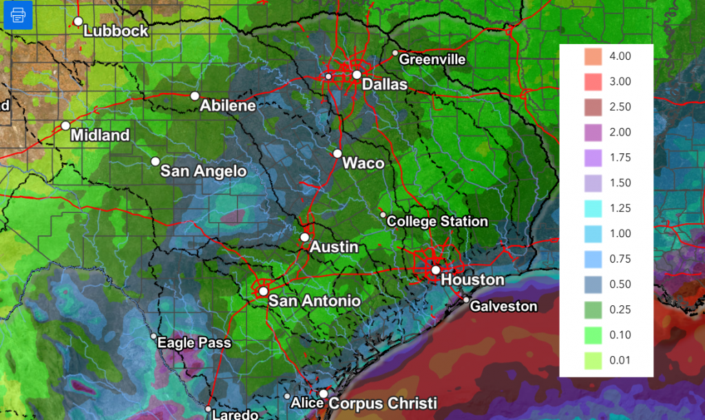
- Additional rainfall Friday night through Sunday is forecast to average between 0.5 and 1.5 inches, with isolated totals to near 4 inches possible
- Sunny and dry weather will return Monday
Discussion
The weather pattern remains unsettled as we head into the weekend. A nearly stationary area of low pressure over the Texas Big Bend continues to draw considerable Gulf moisture inland across the state. A Pacific cold front was nearly parallel to Interstate 35 as of Friday afternoon, with the front slowly moving to the east. The front should finally push off the middle Texas coast sometime late Saturday. This feature is forecast to be the focus for shower and thunderstorm development Friday night and through the weekend. The front is expected to create an environment for the development of overrunning-type rains for areas located to the west of the boundary Saturday through Sunday.
For Friday night through Saturday night, expect periods of rain showers and isolated thunderstorms across the region. The probability for rain will be near 70 percent Friday night, 60 percent Saturday through Saturday night, and 40 percent Sunday. High resolution forecast data for Saturday leans toward the best chance for rain occurring across the Hill Country region, where the overrunning pattern will be the most pronounced. However, the exact placement of the precipitation remains somewhat uncertain.
Spotty rain showers will continue across the area on Sunday as the upper low over the Big Bend finally begins to shift to the south. Sunday’s rain isn’t expected to be as widespread or as persistent across the Hill Country and Central Texas regions as the rain that is forecast for Saturday. The coastal region is expected to see some widespread, moderate rain.
All the rain is predicted to decrease/dimmish Sunday night as the Big Bend upper low finally exits the region and a ridge of high pressure begins to spread over the state. Mostly sunny and dry weather is forecast Monday.
Additional rain amounts through Sunday night are forecast to generally average between 0.5 and 1.5 inches. However, some isolated pockets of 2-4 inches will be possible where the rain ends up being more persistent.
NWS Rainfall Forecast Valid 7 pm Friday through 7 pm Monday:
The outlook for next week calls for mostly sunny and dry weather as a ridge of high pressure spreads over Texas from the west. A dry cold front is forecast to spread south across the area Monday, bringing in drier air. High temperatures next week are forecast to be mostly in the mid and upper 80s. Low temperatures are predicted to fall to the upper 50s across the Hill Country, the low 60s across Central Texas, and the mid to upper 60s coastal zone.
Have a great weekend!
Bob
Social Media