Quiet Weather Expected this Week. Trending Warmer and More Humid
May 11, 2026
Sunday evening’s stormy weather has pushed well to the east of our region thanks to the passage of a weak cold front. Sunday’s storms produced wind gusts of 40-50 mph across much of the area. Austin-Bergstrom International Airport and Georgetown Municipal Airport both reported wind gusts to 64 mph. Hail was reported with some of the storms, with sizes ranging from pea size to near 1 inch in diameter.
Rainfall was hit and miss, with some locations reporting totals up to 3-4 inches, with several spots recorded less than a quarter inch. Some of the most widespread heavy rain appears to have occurred over the area between Austin and College Station. LCRA’s highest gauged total was 3 inches at a location in western San Saba County. A CoCoRaHS rainfall observer located just east of Bastrop recorded a storm total of 4.13 inches.
NWS Estimate of Rain Falling Between 7 am Sunday and 7 am Monday:
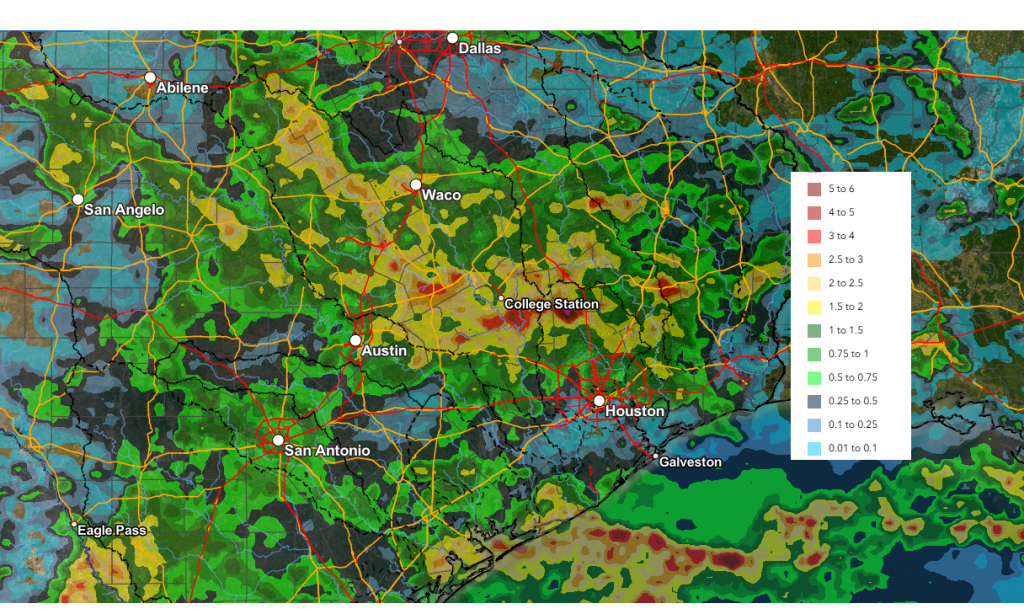
Data courtesy of NWS West Gulf River Forecast Center
The weather this week is expected to be sunny and quiet. A large ridge of high pressure situated over northern Mexico and the western U.S. is forecast to slowly shift east through the week, keeping the weather across Texas dry and warm. Light northerly winds behind this morning’s cold front are expected to keep the temperature a little lower today through Tuesday.
- High temperatures Monday will range from the mid-70s to the low 80s
- Lows Tuesday morning will include the upper 50s across the Hill Country, the low 60s across Central Texas, and the mid-60s near the coast
- High temperatures Tuesday will be in the low and mid-80s
- Lows Wednesday morning will be in the low and mid-60s
Warmer readings and higher relative humidity levels look to return beginning Wednesday and continue through the weekend as southerly breezes increase off the Gulf. Expect southerly breezes to be in the range of 10-15 mph through the period. Daily high temperatures are forecast to be near 88-90 degrees. Low temperatures are predicted to generally be in the low and mid-70s.
A chance for scattered rain showers and thunderstorms will enter the forecast on Sunday as a trough of low pressure begins to set up across the Desert Southwest this weekend. Disturbances rotating around the trough are forecast to begin moving over Texas Sunday and continue through the middle of next week. Extended-range forecast guidance suggests totals of 0.25 to 0.5 inches Sunday, with the possibility for some higher totals early next week. Stay tuned for additional updates.
No significant change in the temperature is forecast through next week.
Solar Activity Alert
The odds of an Earth-directed solar flare are increasing this week as sunspot 4436 turns toward our planet. On May 10th, the active sunspot region produced an M5.7-class solar flare, which blew a massive hole in the sun’s atmosphere. This flare appears to be heading for a near miss with Earth and should pass by on Wednesday.
The next explosion might not miss. This sunspot has had a history of producing large flares. Last week while it was on the far side of the sun it produced at least 5 Coronal Mass Ejections (CMEs). If the serial explosions continue in the days ahead, Earth will be inside the strike zone. (Spaceweather.com)
Have a great week!
Bob
Social Media